


Garmin 695/696


Join Date: Oct 2004
Location: HLS map - http://goo.gl/maps/3ymt
Posts: 439
Likes: 0
Received 1 Like
on
1 Post
Anyone any ideas on AGL height? In terrain page it obviously knows our aircraft height and terrain height, but why cant it provide height AGL in the data rows on the map page? Thinking it would be useful for 500' rule, and flying in france/switzerland
Join Date: Apr 2007
Location: UK
Posts: 8
Likes: 0
Received 0 Likes
on
0 Posts
Attempt at pictures
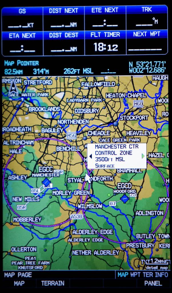
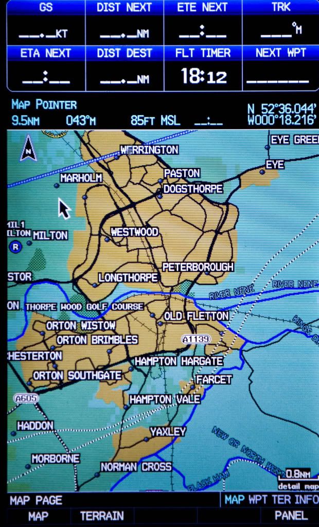
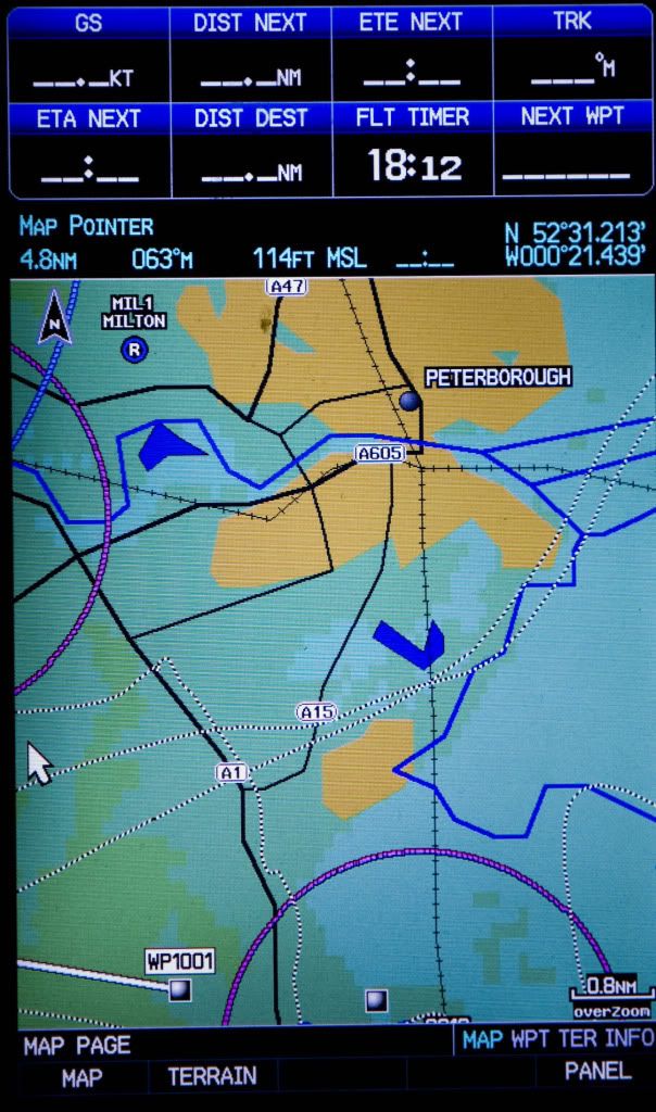
Screenshot images show Peterborough at 0.8 with and without the card in, plus EGCC at same range with card in. Notice how with the card, the breadcrumb trail in the SW corner from when I left the unit on in the car matches the path of the A1 and A605 exactly, whereas the track on the version with the basic data is a long way out and the 605 is just not in the right place at all. The 20-year-old bypass isn't on it! The rivers and railways are much smoother and better resolved. Standing at on the apron at Conington the unit as originally purchased would show me as being to the East of the railway, whereas all of the airfield is to the West - the error being in the position of the railway; GPS coords are spot on. The basic mapping just isn't very good (awaits flames).
Dick
Last edited by cyclic phenomenon; 5th Mar 2011 at 07:26.
Join Date: Apr 2007
Location: UK
Posts: 8
Likes: 0
Received 0 Likes
on
0 Posts
I don't mind the detail, which is useful when I'm trying to find a site with which I'm unfamiliar. I guess it is of course down to preference, and you can declutter and trim the detail settings at various magnifications. I just like ground features actually being the right shape and in the right place. For the plank-ists and people happy with half-mill maps this probably not such a interest; the aviation features are spot-on. Praps it's that I don't have thousands of hours and find the extra info kind of reassuring.
Join Date: Sep 2003
Location: Portland and Various
Age: 47
Posts: 80
Likes: 0
Received 0 Likes
on
0 Posts
The pictures are great, thanks for them. I'm trying to get our units upgraded with the map software, so that the highways we land on are actually on the screen where they actually are!
Join Date: Nov 2004
Location: Scotland
Age: 56
Posts: 57
Likes: 0
Received 0 Likes
on
0 Posts
Good afternoon gents.
We've just purchased City Navigator NT on a preprogrammed SD card for our 695. I was just going to pop the card into the 695 and start her up but a little warning that came with the card, says that "Using preprogrammed memory cards to transfer Mapsource map data overwrites the preprogrammed data."
Any ideas on the correct procedure to add this software to the box? Garmin wouldn't help, as the unit and software are not supposed to be compatible (but it obviously works as per the postings above).
Many thanks
C.
Join Date: Apr 2007
Location: Center of the Universe
Posts: 645
Likes: 0
Received 0 Likes
on
0 Posts
Updating 696 software & databases
It is now possible to update system software and databases via an SD card rather than using a USB cable connected to a computer. Much easier and no need to remove the GPS from the aircraft!  Details on www.flygarmin.com and www.garmin.com.
Details on www.flygarmin.com and www.garmin.com.
Join Date: Jul 2010
Location: croatia
Age: 48
Posts: 4
Likes: 0
Received 0 Likes
on
0 Posts
garmin 695 cities
Hi!
I am from Croatia. We bought recently garmin gps 695. The problem is that on the gps isnt any croatian city. do we need to buy some database to have cities or ???
Thanks!
I am from Croatia. We bought recently garmin gps 695. The problem is that on the gps isnt any croatian city. do we need to buy some database to have cities or ???
Thanks!
Join Date: Nov 2004
Location: Scotland
Age: 56
Posts: 57
Likes: 0
Received 0 Likes
on
0 Posts
Thanks EN48, I just decided to pop the sd card into the unit, switched on and hey presto, there it all was.
Point for all to note tho, if you update your 695 via sd card using the standard databases (new versions, obstacles etc), then it is just that, you upload to the 695 and the information is stored on the 695.
The information on the City Navigator NT however, remains on the sd card. Remove the card from the 695 and you no longer have access to the NT info. Pop the card back into the 695 and your good to go again
Knowing me and computers, I'm probably doing something wrong but it works
Cheers
C.
Join Date: Apr 2007
Location: Center of the Universe
Posts: 645
Likes: 0
Received 0 Likes
on
0 Posts
The information on the City Navigator NT however, remains on the sd card. Remove the card from the 695 and you no longer have access to the NT info. Pop the card back into the 695 and your good to go again
Join Date: Jun 2010
Location: EU
Posts: 79
Likes: 0
Received 0 Likes
on
0 Posts
Garmin 695 question
Have Garmin Question.
After making a FPL and entering the airspeed, the garmin used to give me ETE and leg ETE, in planning mode.
I did the 2012 update and then it stopped doing so. When I'm flying everything works well, but I miss my planning fase ETE feature.
I also used to change the plan-speed, to check out time/fuel if I'd run into some strong headwinds.
Maybe someone knows, it might be a wrong setting...
Thanks
FTF
Join Date: Mar 2008
Location: England and Central Europe
Posts: 31
Likes: 0
Received 0 Likes
on
0 Posts
Still having problems...
Sorry to resurrect this one, but I'm hoping to learn from others' misfortunes rather than having to go through them all myself.
I bit the bullet last week and bought a 695, intending to put the VFR Jepp plates (Sierra) edition onto it. I (think I) bought all the right things - unlock key from Garmin, subscription from Jepp etc. I think I also followed the process correctly, used JSUM to download to SD card then install using the SD card. The end result was - nothing! I have the plates on my iPad, but not on my 695.
I called Jepp support. They used my username and password and came up with the same problem as I did. The issue, it seemed, was missing source files. They set me up an IFR subscription that they said should cure the problem - I now have very nice IFR approach plates on the 695 that I can't use as I am strictly VFR only, but no VFR plates.
Has anyone been through this recently? Have I missed something? I've emailed Jepp, but they haven't come back to me. Grateful for any assistance the forum can give.


Join Date: Mar 2008
Location: England and Central Europe
Posts: 31
Likes: 0
Received 0 Likes
on
0 Posts
Having traded up from the 296, I love the size of the 695. I'm just frustrated the same problems that beset the early adopters 3+ years ago still seem to be there in the latest Garmin / Jepp combinations!
