


ATPL theory questions


If you have access to Aviation Exam, they have a supplement document you can download, with all the pics used in the workbooks by the UK CAA.
I revised for a week using that site, walked out with 92 percent.
I revised for a week using that site, walked out with 92 percent.
Join Date: Jun 2013
Location: Singapore
Age: 36
Posts: 39
Likes: 0
Received 0 Likes
on
0 Posts
For CAAS(Singapore)
The work book would be similar to the cap but extremely brief. For my exams there were no load and trim sheets.
You need to be familiar with some aspect of flight planning tables e.g. the climb performance, time and fuel consumed tables (not the graph).
Other than that, if you are familiar with the formulas you should be fine.
Join Date: Dec 2004
Location: IOM
Posts: 183
Likes: 0
Received 0 Likes
on
0 Posts
Hi guys
Sat ATPL Mass and Balance this week, amongst others. Results are due tomorrow.
The workbook provided for M&B contains graphs and charts that some of the questions will ask you to determine an answer from.
E.g. 'Refer to figure 011 in the workbook. What are the forward and aft CG limits of an aircraft with a landing weight of 58,000KG.'
They do not contain conversions or useful information. However, on one question which asked you to calculate maximum allowed fuel load based on given BEM, variable and traffic loads, they provided the table of standard passenger weights.
Bear in mind this may not be the case for other questions asking you to calculate specific allowed mass.

Join Date: Apr 2015
Location: Blighty & Germania.
Posts: 76
Likes: 0
Received 0 Likes
on
0 Posts
Just passed the FAA ATP writtens first go (84%) after a week of both Sporties Pilot Shop books and the Sheppard Air online ATP Multi course.
The exam was a joke as I did not get one complex flight planning question, just easy graphical and W&B ones. The only calculation I got wrong was coverting an RVR of 5,000 ft to US miles. My calculator only did feet to NM, not US jobs!
If you have to suffer the FAA ATP writtens (The CAE CTP course was easy, although they are rather expensive), make sure you gen up on all the factors and definitions relating to CRM, as some of the questions seem to have 2 correct answers. It might well be turning into a real tough exam for the none native English drivers.
I'd only seen about half of the questions before, so it appears the FAA are trying to stop folks passing who just remember the answers.
Join Date: May 1999
Location: Bristol, England
Age: 65
Posts: 1,804
Received 0 Likes
on
0 Posts
Hi Portvale,
Yes, this would stump me. It is true (although rather obvious) that there can only be one sunrise and sunset each day, which is what the preamble to the question says.
The times of sunrise and sunset are given for a range of latitudes in Local Mean Time (LMT) for a particular day. Thus they are correct for all longitudes as LMT, but will need to have the time converted to UTC and possibly Standard Time depending on requirements.
Answer (b) is possibly true if 'these data are accurate only for places on the Greenwich meridian' actually means 'these data are accurate when (incorrectly) read as UTC times only for places on the Greenwich meridian' which is a bit of a stretch involving either a very badly written answer or a serious lack of understanding of LMT and UTC by the examiner.
As the times are LMT they are enough to be used for all longitudes with appropriate corrections applied, and the inference is that they are used to calculate light conditions, (c) is correct.
The sunrise and sunset times are only correct at mean sea level, and adjustment for altitude can be made, (d) is correct.
My money is on answer (a), but for the shabbiness of answer (b) whoever wrote this question should be flogged. Where is it from, please?

Join Date: May 1999
Location: Bristol, England
Age: 65
Posts: 1,804
Received 0 Likes
on
0 Posts
On reflection, the LMT times of sunrise and sunset will change from day to day, and therefore with the rotation of the earth. The LMT of sunrise at a particular latitude and 179deg59'W might be read from the almanac as 0600 LMT on the 5th March, for instance (made up numbers), whereas the LMT of sunrise from the tables for the next day at the same latitude and 179deg59E (only a few miles away) might show as 0605. Clearly they cannot both be correct, and in fact neither is, because the tables show LMT of sunrise and sunset at greenwich on the assumption that the difference for up to 12 hours equivalent of longitude is not wildly significant. That might be a better reason why (b) is true and avoids me slandering the examiner.
Join Date: Feb 2002
Location: Sunny Solihull
Age: 67
Posts: 265
Likes: 0
Received 0 Likes
on
0 Posts
If you look in the full version of the Air Almanac in the explanations it says :-
in note 2 - that further correction graphs and tables are to be used to correct for the height of the observer. Option D true
in note 4 - sunrise, sunset & twilight are for the Greenwich meridian and it goes on to state there is no significant error in converting to LMT (other than using longitude arc to time). Options B & C true.
So on that A is correct, however I agree not a good question.
Join Date: Feb 2015
Location: bangalore
Posts: 2
Likes: 0
Received 0 Likes
on
0 Posts
Can someone help me with this question
Can someone help me with this question
A pilot wishes to turn left on to a northerly heading with 10 degree bank at a latitude of 50 degree north. using a direct reading compass, in order to achieve this he must stop the turn to an approx heading of
a) 030 degree
b) 355 degree
c) 330 degree
d) 015 degree
A pilot wishes to turn right on to a northerly heading with 20 degree bank at a latitude of 40 degree north. using a direct reading compass, in order to achieve this he must stop the turn to an approx heading of
a) 030 degree
b) 350 degree
c) 330 degree
d) 010 degree
thanks in advance
I need to resit all my ATPL exams as they expired. I have decided to redo them and have rejoined my old school in order to do the progress tests again and be put forward for the exams.
I need to pay extra for the books but I still have my old ones. From reading on here it seems things may have changed in the theory since I did mine 5 years ago. Would my old training manuals still be relevant or have the subjects changed a lot in the last 5 years. Is there things I no longer need to study and has anything been added?
Regards
Join Date: Nov 2000
Location: White Waltham, Prestwick & Calgary
Age: 72
Posts: 4,149
Likes: 0
Received 29 Likes
on
14 Posts
Nothing's really been added or taken away , just shifted - i.e. inertial nav is now in instruments (can't think why). You would probably find that a question database is more up to date.
phil
phil
Join Date: May 1999
Location: Bristol, England
Age: 65
Posts: 1,804
Received 0 Likes
on
0 Posts
Hi aladdin, this question relates to turning errors on direct reading compasses. These occur not because the aircraft is turning but because it is banking, and on certain headings the compass card is allowed, because of the bank, to line up or to attempt to line up with the lines of magnetic flux which are not level with the earth's surface but dive into it at an angle of dip in excess of 60 deg at 50N. The swirl of the liquid in the compass can add to or reduce this effect. There is a good explanation here , page 7.24 on, titled 'dip errors'. I use the acronym UNOS for the northern hemisphere, meaning Undershoot on turns to North and Overshoot on turns through South
The amount to undershoot or overshoot the target heading on turns clearly depends on bank angle, dip (ie magnetic latitude) and target heading. There are various rules of thumb to allow you to estimate this. The FAA Instrument Flying handbook here contains a rather spurious explanation for turning error on page 5.12 together with some rules of thumb for this undershoot or overshoot. On page 7.22 there are some entirely different rules of thumb. In my limited experience these are both of questionable accuracy, and the example in the second case only seems to work because they choose a latitude of about 30N.
When the JAA exams started the UK CAA were asked which rules of thumb we should follow for the exams and they said 'always undershoot or overshoot by 20 to 30 degrees, irrespective of bank angle, and in the exam turns will be on to north or south'. Consequently we apply this rule for the exam, and therefore the answers to your questions should be (a) and (c).
Join Date: Mar 2008
Location: Vrsac
Age: 51
Posts: 28
Likes: 0
Received 0 Likes
on
0 Posts
two thirds of cruise alt for average TAS
Hi ,
This is really bugging me. Please help. Why do we use 2/3 of the cruising altitude for calculating average TAS during climbing (and why we use 1/2 for descent). Why this value? Where is it derived from?
Thanks in advance.
Mirkoni.
This is really bugging me. Please help. Why do we use 2/3 of the cruising altitude for calculating average TAS during climbing (and why we use 1/2 for descent). Why this value? Where is it derived from?
Thanks in advance.
Mirkoni.
Join Date: May 2015
Location: France
Posts: 3
Likes: 0
Received 0 Likes
on
0 Posts
Hi Mirkoni,
First, keep in mind TAS and wind vary with altitude. In order to calculate TOC and TOD position, you need average values of TAS and wind.
During climb, your slope decreases with altitude. So you spend a half time below the two thirds of your targeted altitude and the other half above those two thirds. As a result, the average values to be taken into account regarding wind and speed calculation are the wind and the TAS at the two thirds of your climb layer.
During descent, your slope remains constant. As a result, wind and TAS can be considered as average values at the altitude corresponding to the middle of your descent layer.

Join Date: Jul 2015
Location: Budapest
Posts: 1
Likes: 0
Received 0 Likes
on
0 Posts
Hi! I have one question! Is there any difference between the different Oxford ATPL books issues? Especially concerning the air law... So can I prepare successfully with the older issuses ( like the 2008 edition?). Thank you in advance
Join Date: Dec 2007
Location: Meteorology Avenue
Age: 44
Posts: 189
Received 0 Likes
on
0 Posts
Question about lift in steady climb
A question from PPL question bank(might be also helpful for ATPL):
The right answer is yes, the lift is less than the weight.
Why, as far as I know all the forces(resultant forces) are equal in steady climb?
When the aircraft is climbing with the constant speed the lift produced by the wings is less than the weight of the aircraft?
Why, as far as I know all the forces(resultant forces) are equal in steady climb?
Join Date: May 1999
Location: Bristol, England
Age: 65
Posts: 1,804
Received 0 Likes
on
0 Posts
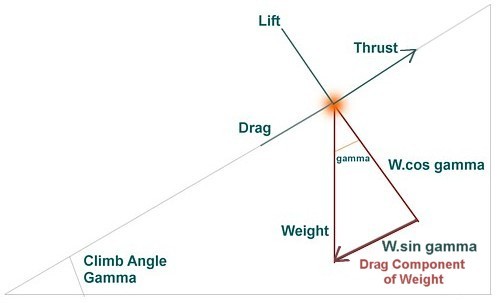
Apologies for using a diagram from somewhere else. In the climb the lift acts at right angles to the chord line but the weight acts directly down. The weight can be resolved into two elements, the force that opposes lift, W cos gamma, and the 'drag' element of weight W sin gamma. You can see that W cos gamma (which should show in the diagram as a vector the same length as the lift, but doesn't quite) is less than the weight, so lift is less than weight. Take an extreme case, an F15 going vertical, lift is zero, all the climb comes from the thrust.
Although this answers your question the next bit is to observe that the forces along the axis of the aircraft are Thrust in one direction and Drag and W sin gamma in the other so we can say that for a non-accelerating climb,
T = D + W sin gamma
resolving this,
sin gamma = (T - D)/weight
Which means that the maximum value of sin gamma, in other words the best climb angle, occurs where there is the greatest excess thrust over drag, VMD for a jet, and where the weight is least.
If you do a google search for "Landing when ACN exceeds PCN", it should lead you to a link to a CAA document entitled
Criteria for operations where ACN > PCN.
This should answer your question in full.
Last edited by keith williams; 29th Jul 2015 at 19:22. Reason: Link did not work
Join Date: Jan 2006
Location: Europe
Posts: 404
Likes: 0
Received 0 Likes
on
0 Posts
Flight Planning - ChartE(HI)4
I'd need some help/opinions with the following question:
Refer to Route Manual chart E(HI)4 CAA
What is the best route from CLACTON CLN 114.55 (51�51'N 001�09'E) to MIDHURST MID (51�03.2'N 000�37.4'W)?
- UB29 LAM UR1 (given as correct answer. I can't see/find a direct connect between UB29 and Clacton)
- TRIPO UR1 LAM UR1
- UR12 (this would be my choice)
- UR123