


Significance of GUND - Geoid undulation ?

Significance of GUND - Geoid undulation ?
I am looking at some AD charts that show values for Elevation and GUND at the thresholds. eg HKMO shows GUND -94.58Ft and elevation 199.6Ft at the threshold of Rwy 21
Looking up GUND tells me that it stands for Geoid undulation, but I am none the wiser for knowing that. Could it refer to deviation from the geoid used by GPS to determine altitude ? Does it have practical significance ?
Looking up GUND tells me that it stands for Geoid undulation, but I am none the wiser for knowing that. Could it refer to deviation from the geoid used by GPS to determine altitude ? Does it have practical significance ?

Does it have practical significance ?

Good question. I think it might be of interest to the designers of instrument procedures, but to us pilots, it’s not really important. Just follow the published chart and you’ll be fine.
Satellites have a circular path. the earth is an oblate spheroid and is not symmetrical in shape, Those differences need to be calculated and programmed into GNSS units. Also, the earths crust varies in thickness and therefore the surface radius from the earth's centre is not uniform. A theoretical circle is drawn at a constant radius from the earth's centre, mirroring the satellite path, and a measure of elevation is taken from it. Some points on the earth will be below it and other points will be above.. This precise data can be programmed into the onboard GPS for corrections and provide for very accurate 3D approaches without expensive ground based equipment. Equipment such as an ILS can run into the millions in cost and require constant maintenance.
The measurements can be found within the AIP aerodrome data.
The measurements can be found within the AIP aerodrome data.
Join Date: Nov 2005
Location: Zulu Time Zone
Posts: 730
Likes: 0
Received 0 Likes
on
0 Posts
Geoid is theoretical mean sea level which is the vertical reference we need. It is somewhat irregular and therefore an ellipsoid can only approximate it. The GPS (not GLONASS) uses the WGS84 ellipsoid. The GUND is the local difference between the two. Modern GPS units also have the geoid data so they are able to provide altitude MSL.
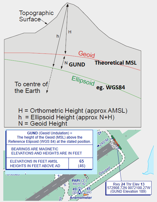
This tells you that the threshold is 199' above the geoid (MSL). The -94' indicates the geoid at this location happens to be lower than the ellipsoid. The pilot does not need to know this because his primary reference is the altimeter which when set to QNH is theoretically the same vertical reference as the geoid anyway. But it would be a good idea to know if your GPS is giving ellipsoidal height or altitude MSL.
eg HKMO shows GUND -94.58Ft and elevation 199.6Ft at the threshold of Rwy 21
