


Bankstown RNP RWY 11 approach on Garmin G1000

Thread Starter
Bankstown RNP RWY 11 approach on Garmin G1000
When carrying out the Bankstown RNP RWY 11C approach from the RAKSO IAF with a Garmin G1000 equipped aircraft while coupled to the autopilot, strange things happen. Fly over RAKSO at 3,700 feet and the Garmin unit doesn’t start descending to the 2,500’ SBKWI IF until there is a 3˚ approach angle. This would put the aircraft into the 2,500’ step.
In fact, if you look at the approach plate, it shows the descent should start at RAKSO from 3,700’, then go at a constant angle to WI at 2,500’. Once again, that means that the aircraft will clip the 2,500’ 20 DME Sydney Class C step. In effect, it means that the expensive and safer autopilot coupled system can not be used in this case.
Does anyone have an answer to this as to why the Garmin approach doesn't actually follow what is required in practice?
Last edited by Dick Smith; 17th Mar 2022 at 02:56.

Dick,
The approach coding for that procedure does not have any coded vertical guidance prior to SBKWI. Any vertical advisory provided before this point is Garmin system derived, and not from coded data. Therefore the only vertical advisory the system can generate is based on a known final altitude......the only coded 'known' final altitude is the 2500ft at SBKWI and so it generates a path to this point. In this particular instance, because there is a break in the descent, the vertical advisory provided will not ensure you reach 2500ft by 6.5nm to SBKWI.
Its a case of the navigation systems 'smarts' being smarter than the approach. It happens.
Alpha
Join Date: Sep 2016
Location: Australia
Posts: 38
Likes: 0
Received 0 Likes
on
0 Posts
If it's any consolation Dick, a 'modern' 747-8 would have the same problem with its new 'Integrated Approach Navigation' mode. We won't arm this mode for RNP/RNP-AR descent until all altitude constraints are complied with and we're approaching the FAF.
Have not flown G1000 in 9 years and unfamiliar with the approach, I’m just looking at the plate:
https://www.airservicesaustralia.com..._24MAR2022.pdf
I’m not understanding why a 3 degree from Rakso to SBKWI would encroach the 2500’ shelf. That’s 20.3 miles and it should start descending approximately 3.7 miles out.
https://www.airservicesaustralia.com..._24MAR2022.pdf
I’m not understanding why a 3 degree from Rakso to SBKWI would encroach the 2500’ shelf. That’s 20.3 miles and it should start descending approximately 3.7 miles out.
My FMS would do the same. For obvious reasons, it tries to stay as high as it can. Since there is no limiting step on the chart at 6.5WI, the FMS will stay up until in needs to descend to reach 2500ft at WI. In fact, my FMS would probably go through RAKSO around 5000ft (and WB at around 3000ft, for that matter). Airspace steps are not in my database and the box knows nothing of them.
If this particular airspace config doesn't change, then an "at or below" step at 6.5WI would be in order. Whether that is an allowed design feature for an IAF>IF leg is another issue. And don't be naughty and edit the approach to put in a step.
Or, "request a clearance to leave and re-enter"... (note note 4).
I do not agree. A line on the profile chart doesn't mean you (or the box) have to fly exactly along it. It is merely depicting that a descent is necessary at some point between RAKSO and WI. You could actually pass RAKSO then whip it into VS, zip down to 2500ft and then wait for WI.
The box would only have to commence descent from 3700ft at 3.7nm from WI (assuming it will try to descend at around 3°), but the step is passed at 6.5WI. You'd be crossing 6.5WI still at 3700ft.
If this particular airspace config doesn't change, then an "at or below" step at 6.5WI would be in order. Whether that is an allowed design feature for an IAF>IF leg is another issue. And don't be naughty and edit the approach to put in a step.
Or, "request a clearance to leave and re-enter"... (note note 4).
Originally Posted by Dick
In fact, if you look at the approach plate, it shows the descent should start at RAKSO from 3,700’, then go at a constant angle to WI at 2,500’.
Originally Posted by B2N2
I’m not understanding why a 3 degree from Rakso to SBKWI would encroach the 2500’ shelf. That’s 20.3 miles and it should start descending approximately 3.7 miles out.
Last edited by Capn Bloggs; 18th Mar 2022 at 01:52. Reason: Grammar

Just another thought, the approach plate has a SYD CTR frequency, they’re the ones clearing you for the approach.
The hard altitude is 2500’ that one should be respected by the G1000.
Should be 4 ways to do this :
The hard altitude is 2500’ that one should be respected by the G1000.
Should be 4 ways to do this :
- VNaV 3 degrees
- VNaV release the altitude, descend early to intercept the path
- Descend in Vertical Speed
- Descend in FLCH
When carrying out the Bankstown RNP RWY 11C approach from the RAKSO IAF with a Garmin G1000 equipped aircraft while coupled to the autopilot, strange things happen. Fly over RAKSO at 3,700 feet and the Garmin unit doesn’t start descending to the 2,500’ SBKWI IF until there is a 3˚ approach angle. This would put the aircraft into the 2,500’ step.
In fact, if you look at the approach plate, it shows the descent should start at RAKSO from 3,700’, then go at a constant angle to WI at 2,500’. Once again, that means that the aircraft will clip the 2,500’ 20 DME Sydney Class C step. In effect, it means that the expensive and safer autopilot coupled system can not be used in this case.
Does anyone have an answer to this as to why the Garmin approach doesn't actually follow what is required in practice?
In fact, if you look at the approach plate, it shows the descent should start at RAKSO from 3,700’, then go at a constant angle to WI at 2,500’. Once again, that means that the aircraft will clip the 2,500’ 20 DME Sydney Class C step. In effect, it means that the expensive and safer autopilot coupled system can not be used in this case.
Does anyone have an answer to this as to why the Garmin approach doesn't actually follow what is required in practice?
The initial segment from RAKSO to WI is actually from the Westmead Hospital RNP 052 chart, that charts has crossing WI at 2700 (it’s steeper at 3.07 degree). To fly the BWU approach at near 3 degree all the way, cross RAKSO at 6700 ft (13.3 nmx318 ft/nm +2500), cross 6.5 WI at 4600 (6.5x318+2500), that is the 2500 ft SY step, cross WI at 2500.
The chart is a LNAV chart, i.e. 2D, there is no descent angle coded in database. What annunciation did you have on the HSI, LNAV or LNAV+V ?
So back to Dicks issue. Each navigation manufacturer can tweak the procedure coding to optimise performance for that particular navigation system. The final version of coding for each system will differ and its why the Collins Proline and Garmin system each fly the procedure differently.
You will also notice that the 2500ft altitude at SBKWI is an AT altitude, so this altitude will be honoured. How the aircraft gets there is up to each individual manufacturers navigation logic.
Alpha
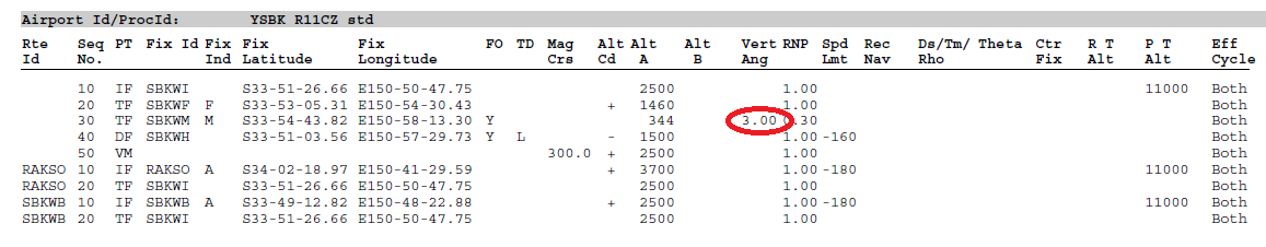
There is actually SWH....see attached extract of procedure coding (my red circle is the vertical path angle for the final segment)..........this only goes back to the FAF. There is no coded vertical path prior to the FAF. (Note this is source coding....not final coding for a specific navigation system)
I don't think its ever been automation's responsibility to keep an aircraft OCTA. Obviously, VNAV is capable of flying and meeting the level restrictions and forming/flying an approach path, but I believe it has always been the pilot's responsibility where if they haven't been cleared to enter and leave airspace ( or in this case via the RNP approach), to maintain separation from airspace.
I think in the case of this approach. Some aircraft ( potentially heavier, unfamiliar to the local environment aircraft such as private jets or potentially larger aircraft) it isn't efficient or safe to be descending early on that initial leg or the approach as whilst it does get you below the CTA step, it places you smack bang in the middle of the training area in particular with aircraft headed to the inbound reporting point TWRN. Therfore, it would be expected that in some scenarios, aircraft would be cleared to enter CTA via the RNP approach into BK and thus can fly the aircraft as depicted on the chart and negate CTA steps.
If Garmin put an altitude restriction to get the aircraft OCTA by the step, aircraft that had been cleared to enter CTA would now descend OCTA if following that VNAV profile.
I think at the end of the day, id imagine it wouldn't be feasible for there to be an option to select if the pilot had been cleared to enter CTA or remain OCTA, so therfore build the approach and code it as any other approach, and make the pilot responsible for remaining OCTA as they should .
Practically, you would brief that you must descend from at or above 3700 to 2500 by 6.5nm WI. This essentially makes the RAKSO- WI leg 6.8nm ( as you need to be at 2500ft by 6.5nm WI) rather than the 13.3nm unrestricted leg.
6.8nm x 318ft ( 318ft per nm for a 3 degree descent path) = 2162ft. This means that to fly a 3 degree descent and be established at 2500ft by the step, you can cross RAKSO at 4662ft ( 2500ft+2162ft), rather than the published 3700ft. This enables you to stay higher longer and delay your initial top of descent from cruise by a few miles.
If you indeed crossed RAKSO at 3700ft, you could level off and maintain 3700ft. 3700ft-2500ft= 1200ft to lose. 1200/318ft= 3.77nm. Therfore, your descent should begin at 10.27nm WI to fly a 3 degree descent from 3700ft to 2500ft and not clip the step at 6.5nm WI
Obviously, you could also cross RAKSO at 3700ft and descent straight away to 2500ft. Whilst this is less complicated, you are flying longer at low altitude which is less efficient and also having more conflict with training area traffic.
Tossbag, different manufacturers modify the coding in order for their specific navigation system to perform in a certain way for certain aircraft. For example its widely known that Boeing and Airbus navigation systems perform vertical path generation differently depending on the aircraft being flown. All whilst utilising the original coded data from Jeppesen. Even Garmin post process the Jeppesen data for different navigation systems.
SWH, that screenshot is from the Jeppesen database, granted its an older cycle so unless it have been taken off, which I am not aware it has been, then it is accurate. How are you viewing the coded data? The procedure doesn't have to be a VNAV procedure to have the vertical path angle in the coding, hence the lack of temperature limitations.
Alpha
Thankyou Alpha.
Boeing & Airbus "in order for their specific navigation system to perform in a certain way for certain aircraft" as in, due to the different aerodynamic properties of individual airframes?
Boeing & Airbus "in order for their specific navigation system to perform in a certain way for certain aircraft" as in, due to the different aerodynamic properties of individual airframes?
Tossbag, yes pretty much.
From my own experience it seems that Boeing aircraft systems seem to favour a 2.5-3 degree profile, whereas the Airbus logic is not quite as straight forward and in some cases goes towards a more dive and drive profile. This can vary based on weight, wind, and temperature. Its just the different logic used in the navigation systems.
Garmin systems being more GA focused seem to also favour a 3 degree profile. The key thing to remember here is that the system is only as smart as the information it hold. In the Bankstown case for the RAKSO-SBKWI leg there are only 2 known points that being RAKSO or SBKWI (the 6.5nm fix and the airspace boundary are unknown to the system). So starting at 3700ft at RAKSO and wanting to be 2500ft at SBKWI presents some options..
a) I can give you a 3 degree descent from 3700ft @ RAKSO to 2500ft, or
b) I can give you a 3 degree descent to 2500ft @ SBKWI from 3700ft, or
c) I can plot a constant descent from 3700ft @ RAKSO to 2500ft SBKWI which would be 1.5deg (approx)
These are pretty much the only coding options available......each nav system manufacturer may choose a different option....and each of them are valid for a specific system/aircraft. For example option a) may be suited Cessna 400 series piston aircraft allowing for deceleration. Option b) may be more suited to turboprop aircraft and option c) may be suited to jet aircraft. In all cases the start, end and minimum altitudes are honoured.
I hope this helps explain it.
Alpha