


Erasing Safety?


Thanks for finding them LB. Looking at Google Earth at a couple of them, there appears to be some basic form of dirt strip there. Sunfish, I'll admit to not having a clue about what the U means in this context. Regarding removing unverified strips I'd much rather know they were there - I won't be using them either way, but if I hear somebody broadcasting that they are downwind at WoopWoop Station I'll know where they are and can stay out of their way or disregard them as being nowhere near me and not requiring action.


Join Date: Apr 2019
Location: Australia
Posts: 358
Likes: 0
Received 0 Likes
on
0 Posts
Regarding removing unverified strips I'd much rather know they were there - I won't be using them either way, but if I hear somebody broadcasting that they are downwind at WoopWoop Station I'll know where they are and can stay out of their way or disregard them as being nowhere near me and not requiring action.
Plenty more of them on the current maps.
I’m with you!
I‘d much rather know where they are, just in case I find myself in/mismanage myself into a precautionary landing/forced landing situation. It may be that in a particular case the strip is as unusable as the surrounding gaffa, but it could be that it’s not. (PS: What Stickshift said!)
(Coincidentally, the most recent sat photo of Narwietoomah suggests it would be a better option than the surrounding gaffa.)
Regarding removing unverified strips I'd much rather know they were there.
I won't be using them either way.
(Coincidentally, the most recent sat photo of Narwietoomah suggests it would be a better option than the surrounding gaffa.)
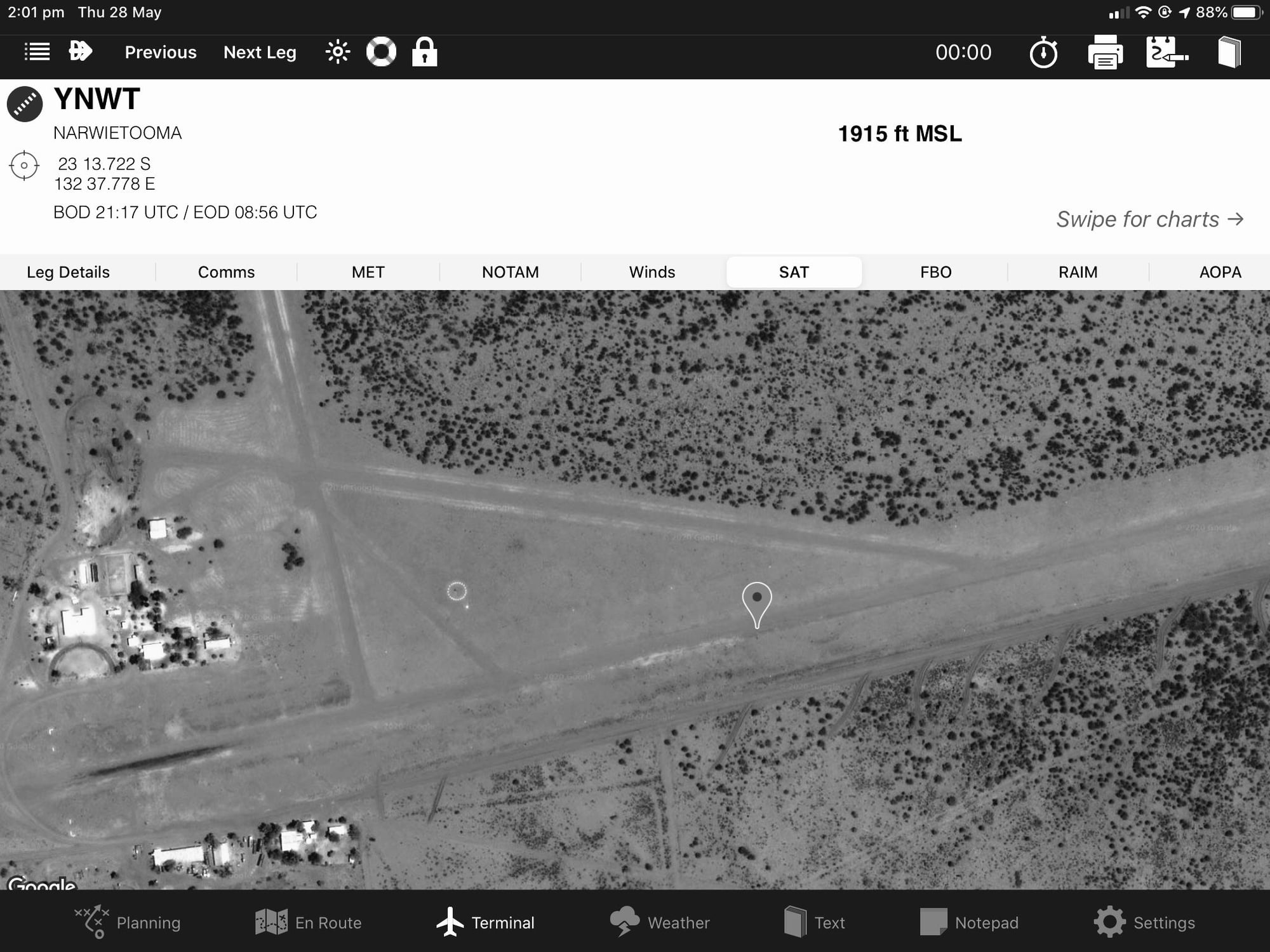
In an emergency, I’ll opt for the unverified strip instead of the surrounding gaffa.
This thread and others about Part 175 provides some insight into why this is happening: Lost - 2000+ airfields
has the earth moved over the last 20 years?
After all this, has anyone actually established what a circle with a "U" in the middle actually means and where is it published?
As for Merty Merty, how dare they delete such a fine airstrip. It was fine the last time I landed there in the 70s.
If I remember correctly, it was a multi-directional airfield. Just a big claypan.
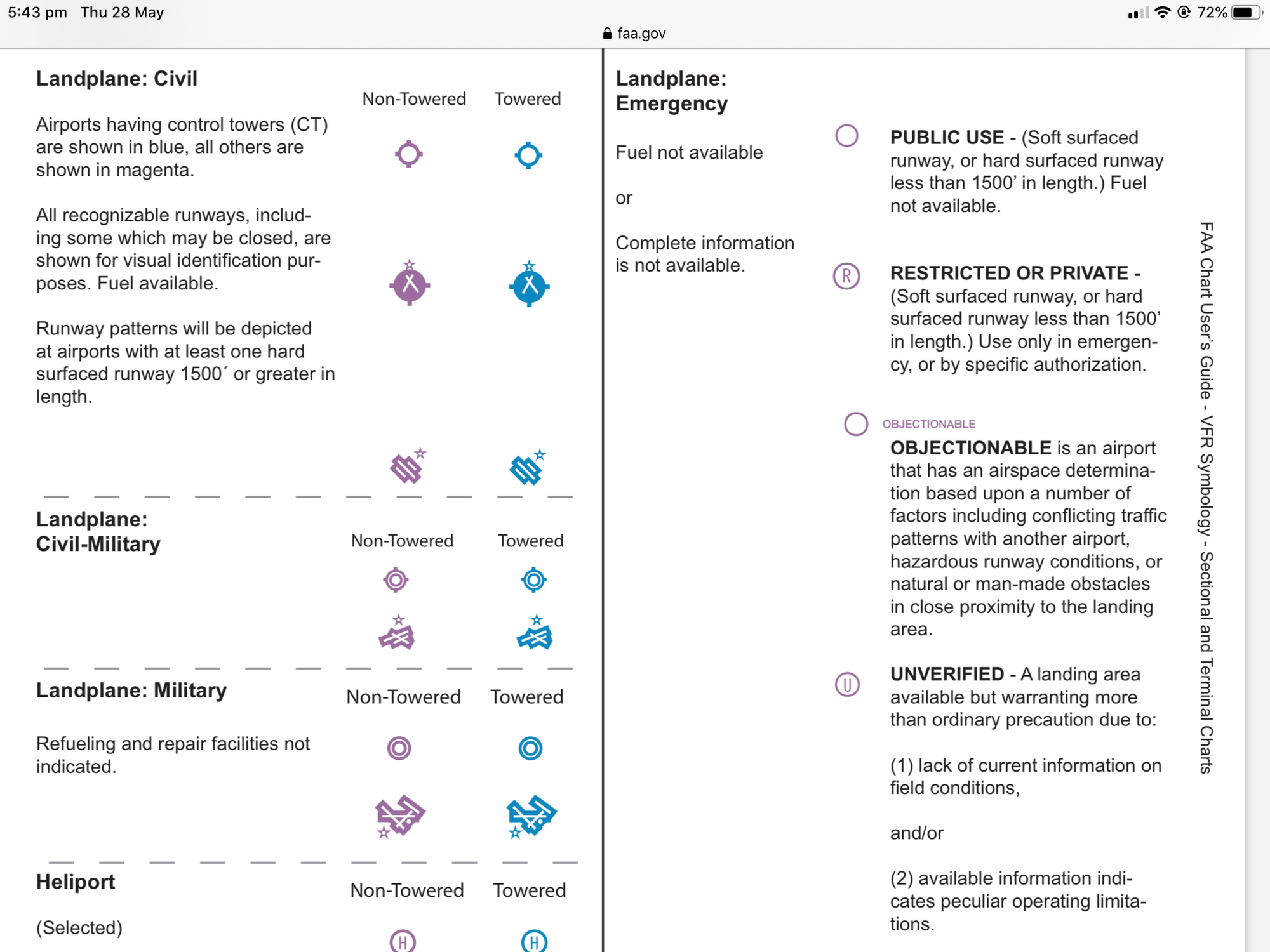
Perhaps the unbroken circle with a “U” is some remnant of a valiant attempt to align with US chart symbology: https://www.faa.gov/air_traffic/flig...g-complete.pdf
My brief research suggests that the interesting question is: Where did the broken circle symbology on Australian charts come from (apart from the obvious)? My wild guess is that CaptainMidnight, alphacentauri or Vag277 might have some insights.
My brief research suggests that the interesting question is: Where did the broken circle symbology on Australian charts come from (apart from the obvious)? My wild guess is that CaptainMidnight, alphacentauri or Vag277 might have some insights.

I have to say I find some of these posts really quite funny.....
In terms of �I�d much rather know they were there�, I find this a ridiculous premise. So are you going to fly over a perfectly good forced landing paddock to glide to a place you know �was� there? Or do you need to divert to a place because you�ve planned poorly? I can guarantee you there are many many unverified locations that are either in the wrong place, have been ploughed or are now housing estates. And if you �know it was there� why do you need a chart when you�re in the sh!t anyway? The only reason these places have remained on the charts is because some RAPAC members were in denial that these places no longer exist and kicked up a stink on the same ridiculous basis as the arguments on here..
There was a push by Airservices to remove any unverified locations from the charts a few years ago for very good reason, the previous examples being two of them. In the world of data, there is no place for poorly managed, unvalidated or duplicate data. We rely on this data way too much now to have it be incorrect. Part 175 or not, we can�t afford bad data. Think of old mate with his Ozrunways and The aerodrome he is going to is in the wrong location on the chart, he hasn�t done any visual navigation and is totally reliant upon that? Poor airmanship yes, but also demonstrating the need for good data. Did you know these single source datasets are also in FMC databases?
I know there are all these conspiracy theories and haters Of government organisations, but the reality is a simple modern problem, not only in aviation either.
Yes, many aerodromes have been demolished and yes it�s a sad state of affairs. But by putting nostalgia on the charts isn�t the solution.
Thread Starter
Flying Higher, I agree with you, either remove them or improve the data. The issue is indeed quality of data. You want charts, all charts, to inform the user, pilot, hiker, ships captain with the best knowledge available for their intended use. You do not want a chart to be ambiguous or misleading.
The data is not “unverified” call it “unknown” instead. Even mark it as ruins or leave it out (but that is another argument). We have done the same on land and sea charts for decades.
Whatever you do, don’t leave the pilot in doubt as to expectations or provide misleading expectations.
My reason is also that in the absence of “good” data, gossip, mud maps, hearsay and rumor will fill the gaps - and that most definitely will lead people astray. For that same reason I’m pleased that the VFRG and many charts are now available for free download.
I have to say I find some of these posts really quite funny.....
In terms of ‘I’d much rather know they were there’, I find this a ridiculous premise. So are you going to fly over a perfectly good forced landing paddock to glide to a place you know ‘was’ there? Or do you need to divert to a place because you’ve planned poorly? I can guarantee you there are many many unverified locations that are either in the wrong place, have been ploughed or are now housing estates. And if you ‘know it was there’ why do you need a chart when you’re in the sh!t anyway?
In terms of ‘I’d much rather know they were there’, I find this a ridiculous premise. So are you going to fly over a perfectly good forced landing paddock to glide to a place you know ‘was’ there? Or do you need to divert to a place because you’ve planned poorly? I can guarantee you there are many many unverified locations that are either in the wrong place, have been ploughed or are now housing estates. And if you ‘know it was there’ why do you need a chart when you’re in the sh!t anyway?
Last edited by De_flieger; 28th May 2020 at 15:16.
I have to say I find some of these posts really quite funny.....
In terms of �I�d much rather know they were there�, I find this a ridiculous premise. So are you going to fly over a perfectly good forced landing paddock to glide to a place you know �was� there? Or do you need to divert to a place because you�ve planned poorly? I can guarantee you there are many many unverified locations that are either in the wrong place, have been ploughed or are now housing estates. And if you �know it was there� why do you need a chart when you�re in the sh!t anyway? The only reason these places have remained on the charts is because some RAPAC members were in denial that these places no longer exist and kicked up a stink on the same ridiculous basis as the arguments on here..
There was a push by Airservices to remove any unverified locations from the charts a few years ago for very good reason, the previous examples being two of them. In the world of data, there is no place for poorly managed, unvalidated or duplicate data. We rely on this data way too much now to have it be incorrect. Part 175 or not, we can�t afford bad data. Think of old mate with his Ozrunways and The aerodrome he is going to is in the wrong location on the chart, he hasn�t done any visual navigation and is totally reliant upon that? Poor airmanship yes, but also demonstrating the need for good data. Did you know these single source datasets are also in FMC databases?
I know there are all these conspiracy theories and haters Of government organisations, but the reality is a simple modern problem, not only in aviation either.
Yes, many aerodromes have been demolished and yes it�s a sad state of affairs. But by putting nostalgia on the charts isn�t the solution.
Your post manifests the experience of a child of the magenta line, cocooned in the coastal fringe.
I don't know about the history of the introduction of this "U" inside a circle symbol, but I assume that after the fuss in 2015 re deleting ALAs for which data could not be verified, someone in Airservices decided it was a way to placate the industry. What if any consultation was done I don't know, but it seems their charting people may not have been alerted to update the legends. Then of course in 2016 Airservices VRed or IVRed a few hundred of their "back room" people and a lot of knowledge (particularly historical) and expertise went out the door.
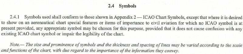
FWIW ICAO Annex 4 Aero charts Appendix 2 has basic recommended symbology:

Then para 2.4.1 says:
So perhaps that's what the FAA and Airservices have hung their hats on to offer additional symbols.
FWIW ICAO Annex 4 Aero charts Appendix 2 has basic recommended symbology:
Then para 2.4.1 says:
So perhaps that's what the FAA and Airservices have hung their hats on to offer additional symbols.
I'm so glad you're amused. How about none of the above? I fly in a lot of regional/remote areas and I won't be landing or diverting to any of these unverified possible strips either, but I don't want to fly straight through someone else's circuit pattern if they've set up a basic ALA. For clarity, if there's nothing whatsoever present, its been bulldozed or built over, the markings should be removed from the chart, but having had a look on Google Earth at a couple of Lead Balloon's locations, there appears to be some form of airstrips present at those places, so I'd rather not fly through their circuit patterns. Having some form of marking on a chart indicating that "hey, theres an airstrip here called Bloggs Field, nothing more about it is known" seems like a reasonable way to do this.
I don't know about the history of the introduction of this "U" inside a circle symbol, but I assume that after the fuss in 2015 re deleting ALAs for which data could not be verified, someone in Airservices decided it was a way to placate the industry. What if any consultation was done I don't know, but it seems their charting people may not have been alerted to update the legends. Then of course in 2016 Airservices VRed or IVRed a few hundred of their "back room" people and a lot of knowledge (particularly historical) and expertise went out the door.
FWIW ICAO Annex 4 Aero charts Appendix 2 has basic recommended symbology:
Then para 2.4.1 says:
So perhaps that's what the FAA and Airservices have hung their hats on to offer additional symbols.
FWIW ICAO Annex 4 Aero charts Appendix 2 has basic recommended symbology:
Then para 2.4.1 says:
So perhaps that's what the FAA and Airservices have hung their hats on to offer additional symbols.
It seems to me that the FAA has stuck with the ICAO symbology of a single unbroken circle, but just added stuff inside (or the curious �Objectionable�).
The provenance of the broken circle on Australia�s charts remains a mystery. And, given that the legend of the Australian chart says a broken circle denotes that the place is unverified, the point of adding the �U� remains a bigger mystery.

I.m with Stick****y..Better to know if 'something' is there rather than the boondocks.
Did nearly suffer the reverse once,, due wx was considering a diversion to xxxxx as map circle, but having reached the intended destination OK ...was advised that xxxxxx was no longer there but was now a tree plantation.
Did nearly suffer the reverse once,, due wx was considering a diversion to xxxxx as map circle, but having reached the intended destination OK ...was advised that xxxxxx was no longer there but was now a tree plantation.
Join Date: Apr 2019
Location: Australia
Posts: 358
Likes: 0
Received 0 Likes
on
0 Posts
Guys,
both the broken circle and circled "U" go back a ways. I thought I had seen them on old charts so I dug out a few. Not my very oldest from the 80s, I don't know where they have got to, but...
WAC charts from the 1990s show _both_ symbols with the following descriptions in the legend.
Broken circle: "Unlicensed Aerodromes. Named in purple. Status and Serviceability Unknown"
Circle with U : "Aerodrome Landmark (unusable)"
It also seems that around 2003/4ish the description on the broken circle symbol on VTCs etc went from "Non Licensed Aerodrome (status unknown)" to "Aerodrome (Not Certified or Registered)"
Certifs.