


Erasing Safety?

Thread Starter
Erasing Safety?
Unless I am mistaken, which is always possible, the latest charts I’ve seen have some airstrips marked with a big fat “U” - which I take to mean uncertified. Other strips or ALA, for example the dig tree strip, have been completely removed. What is going on?
Last edited by Sunfish; 25th May 2020 at 22:26.

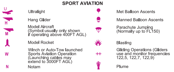
The charts have a legend that explains the symbology ......
Also this details changes:
CHANGES TO AIP AERONAUTICAL CHARTS EFFECTIVE 21 MAY 2020
Also this details changes:
CHANGES TO AIP AERONAUTICAL CHARTS EFFECTIVE 21 MAY 2020
Join Date: Dec 2004
Location: Australia
Posts: 760
Likes: 0
Received 0 Likes
on
0 Posts
Disappointed there was only 31 pages, surely they could have padded it out with a few More "This page is intentionally blank". There could have also been another 20 or so pages of disclaimers plus another 20 or so of credits and references.
Is this the only thing you have to whine about today? Its a list of changes, it takes as many pages as is needed.
Join Date: May 2008
Location: Australia
Posts: 565
Likes: 0
Received 0 Likes
on
0 Posts
I can just imagine Sunfish sitting at the dining room table, frothing at the mouth looking incredulously at the big fat U while he was looking at his chart (without checking the chart legend first!), already working out in his head what he was going to say in his Pprune post and how he could blame CASA for this disgraceful change and the amount of danger it will put us all in. 
"1.4 While every effort is made by Airservices to ensure the accuracy of international data contained in Airservices’ charts and publications, international data is based on, or contains, information provided from regional governments or third party sources over which Airservices has no control, and which may not always be completely up to date."
Silly me, I thought the AirServices produced AIP et al was supposed to be reliable operationally valid information.
CC
Silly me, I thought the AirServices produced AIP et al was supposed to be reliable operationally valid information.
CC
I’m offended by the term ‘manned ballon’, I think there should be a royal commission into the use of this terminology. It should be chaired by Dick Smith and we should look to America for the way they do it. We can then agree at a federal level what the term should be and the states can lock their borders if it is close to election time.
There�s your safety risk right there in the legend. Model rockets and Plumes! Imagine
if one of those hit an aircraft, oh
the humanity!
if one of those hit an aircraft, oh
the humanity!
I can just imagine Sunfish sitting at the dining room table, frothing at the mouth looking incredulously at the big fat U while he was looking at his chart (without checking the chart legend first!), already working out in his head what he was going to say in his Pprune post and how he could blame CASA for this disgraceful change and the amount of danger it will put us all in.
Thread Starter
A circle with a “u” in the middle of it. The actual paper chart may have a description in the legend, the Ozrunways charts legends don’t show it and the strips marked “u” no longer appear in Ersa as far as I can tell. The AIP says nowt.
Deliberately removing information from pilots is not too bright from a safety point of view.
Deliberately removing information from pilots is not too bright from a safety point of view.
I don't know which version of OzRunways you use, but when I go to select a different map on OzRunways, above the list of selectable maps (VFR, ERC, TAC etc) there is the option to select "Legend".
Despite what many may believe, this is not in fact a compliment regarding the user's piloting skills, but brings up an image of a legend that explains the symbols present on the map...scroll down a bit and theres a U and Biggles's angular birdy symbol with the explanation that it refers to locations where ultralights are present.
I don't believe this is a deliberate removal of information at all, it's been there for ages - that symbol has had that meaning for at least 15-20 years that I know of.

It means that the airfield is 'Unverified'. It gets this status whilst Airservices tries to establish reliable contact with the owner in order to keep the data maintained. If no contact is established or the owner is unwilling to maintain the data, the information is removed from the charts.
Thats what the U is for.
Thats why some ALA's have been removed.
Establishment of a data originator is a CASR 175 requirement. No data should be published without a recorded data originator.
Alpha
Thats what the U is for.
Thats why some ALA's have been removed.
Establishment of a data originator is a CASR 175 requirement. No data should be published without a recorded data originator.
Alpha
In monochrome so it was small enough to download. Lots of them. You’re ‘safer’ Sunfish, if you don’t know about these places rather than use an ‘unverified’ ALA in an pinch.
alphacentauri, looking at the legend on my OzRunways chart, the relevant section of which looks like a scan of the WAC chart legend, there are a few different airfield symbols, including the following:
-A circle with a thin inner concentric circle, which represents "Aerodrome - licenced",
-A circle without that thinner concentric circle, representing "Aerodrome/ALA - verified Airservices has a responsible person registered for the location and associated information confirmed"
-A broken circle with 5 breaks in the outline, representing "Aerodrome/ALA - Unverified Airservices has not been advised of a responsible person for this location. Status and serviceability are unknown."
I can't see a reference to the U indicating "unverified" on any chart legends, instead the broken circle is used to indicate an unverified ALA. The same chart legends do use a U to indicate ultralight aircraft activity.