


Melbourne Coastal Route / YMML Runway 34 GBAS

Thread Starter
Join Date: Apr 2008
Location: Australia
Posts: 490
Likes: 0
Received 0 Likes
on
0 Posts
Melbourne Coastal Route / YMML Runway 34 GBAS
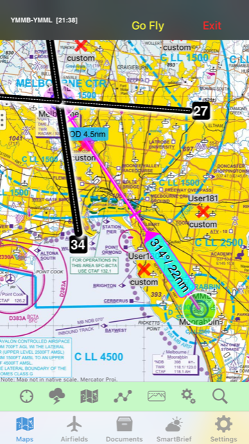
According to AIC H44/18 the CTA above part of the VFR route will be lowered frm 2500 to 2000 feet from 8 Nov to allow GBAS approaches to runway 34 at Melbourne.
If I read the chart correctly (no guarantee!) aircraft on approach to Melbourne will be crossing the VFR lane at 2500. 500 feet clearance below e.g. an A380 on approach doesn't sound like much.
What does it take to get a TCAS RA if e.g. someone in the lane drifts a bit low then climbs back up out of the opposite direction traffic?
Just checked the 8 Nov charts, and the recommendation is eastbound at 2000, westbound at 1500 i.e. westbound is opposite the hemispherical level and opposite to the currently recommended direction.
Things might get a little interesting...

Pictures for some context.
Agreed it could get very tight through there! There are frequently moderately close calls through that area.
Agreed it could get very tight through there! There are frequently moderately close calls through that area.
Thread Starter
Join Date: Apr 2008
Location: Australia
Posts: 490
Likes: 0
Received 0 Likes
on
0 Posts
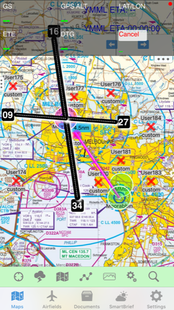
You have to zoom in a long way before the VFR route procedures appear on OzRunways. I predict many OzRunways users will never see them. (To be fair, many paper chart users probably don't read them either.)
There will be a lot of people who don't know the recommended direction at 1500 has changed.
Crazy stuff.
There will be a lot of people who don't know the recommended direction at 1500 has changed.
Crazy stuff.
The opposite levels are dangerous - YMMB wants aircraft leaving the zone at 2000ft so they will now have to descend once outside to 1500ft to track westbound while inbound aircraft are descending to 1500ft to enter the zone...
Thread Starter
Join Date: Apr 2008
Location: Australia
Posts: 490
Likes: 0
Received 0 Likes
on
0 Posts
It's not tolerances so much as that the approach needs to start further from the runway, and according to the discussion paper they need a level segment at 2500. So they need to be at 2500 over the coastal route. 500 feet separation isn't increased tolerances!
500 feet clearance below e.g. an A380 on approach doesn't sound like much.
So why is gbas accuracy so bad that increased tolerances are needed?
Alpha
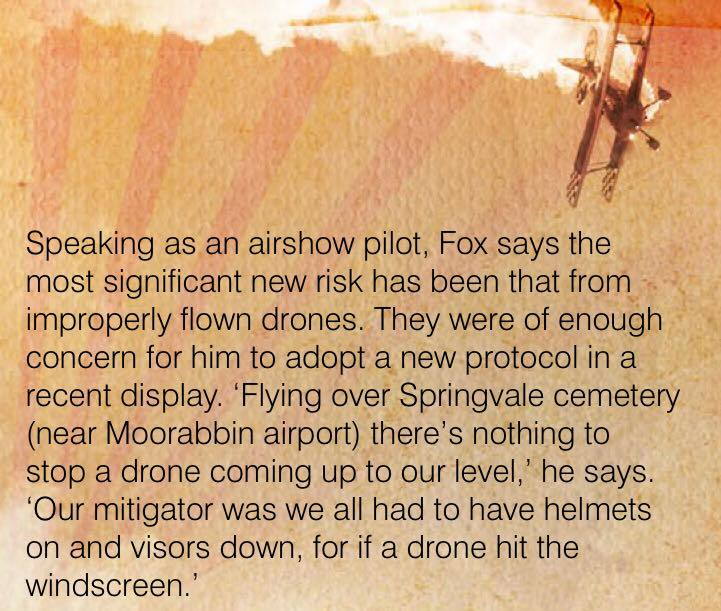
SOP now per CASA's advice regarding drones around Moorabbin (I encountered one at 1500 ft).
As for nav lights - I've never seen the point of using them in day VFR as the whites of the pilot's eyes are more prominent, anyway when I turn them my airplane thinks it is night time and dims the instruments.
As for nav lights - I've never seen the point of using them in day VFR as the whites of the pilot's eyes are more prominent, anyway when I turn them my airplane thinks it is night time and dims the instruments.
Thread Starter
Join Date: Apr 2008
Location: Australia
Posts: 490
Likes: 0
Received 0 Likes
on
0 Posts
Do they? I admit that I don't know the routes of the STARs into Melbourne. I had assumed (implied by the discussion papers) that the current routes were closer to the airport and/or did not cross the VFR route that low. Which STAR crosses the VFR route at 3000?
andrewr,
All of the STARs to RW 34 through OBGAL-AKDEL and BOLTY-AKDEL have a minimum segment altitude of 3000ft to connect to the RNAV RWY 34 approach. The protection areas for theses STAR's sit over the VFR lane. The STAR tracking for the GLS 34 are not changing, but because the altitudes are lowering a piece of airspace had to be acquired to protect the STAR and turn onto the localiser at 2500ft.
Lateral tracks are not changing from the current STAR-RNAV tracking. It is just being lowered at AKDEL by 500ft...that's it
Alpha
Thread Starter
Join Date: Apr 2008
Location: Australia
Posts: 490
Likes: 0
Received 0 Likes
on
0 Posts
The GLS chart also shows ESLOK-AKDEL which is in line with the approach. Is the intention that the straight in approach from further south would never be used?
GLS 34 chart for those interested:
http://www.airservicesaustralia.com/..._08NOV2018.pdf
and new VTC
http://www.airservicesaustralia.com/..._08NOV2018.pdf
http://www.airservicesaustralia.com/..._08NOV2018.pdf
and new VTC
http://www.airservicesaustralia.com/..._08NOV2018.pdf
Yeah that's a modified PORTS arrival, for aircraft from Tasmania. Same tracking as current STAR, but with new waypoint to control descent to 2500ft (currently flown at 3000ft)
You have to zoom in a long way before the VFR route procedures appear on OzRunways. I predict many OzRunways users will never see them. (To be fair, many paper chart users probably don't read them either.)
There will be a lot of people who don't know the recommended direction at 1500 has changed.
Crazy stuff.
There will be a lot of people who don't know the recommended direction at 1500 has changed.
Crazy stuff.
Thread Starter
Join Date: Apr 2008
Location: Australia
Posts: 490
Likes: 0
Received 0 Likes
on
0 Posts
Is the RNAV approach flown so you are level at 3000 before AKDEL (how far before?) or is it flown in a continuous descent to cross AKDEL not below 3000? If flown as a continuous descent you could be significantly higher than 3000, 10 miles from the threshold.
For the GLS approach, are you required to be level at 2500, or can you be above 2500 and descending?
andrewr.
From memory, a 3 degree path requires a descent from 3000ft just passed AKDEL (~0.3nm). So AKDEL is about in the position to be on profile at 3 degrees. Typical turn radius for a 90 degree turn is about 2nm at that point (note 185kt speed restriction). This means that aircraft will not be established on the final approach path (ie complete the turn) until after the profile descent point. For an RNAV approach this is OK. For a precision approach this is not.
Precision approaches require establishment on the localiser before intercepting glide path. The GLS design required getting the aircraft under the glide path, and making the turn lower so they could establish on loc and intercept glide path from below. Doing all of this at 3000ft (particularly on a hot day) would have caused problems, and is not inline with ICAO procedure design rules (PANS-OPS).
Alpha
I'm not hugely happy about this, but it has had significant discussion over the past 18 months or so and has been part of the last round of CASA safety briefings and has had extensive discussion in RAPAC. It shouldn't be a surprise. Many arguments were put, but now we just have to face up to dealing with it. At the end of the day, its pretty much the situation we had 20 or more years ago before the steps were relaxed.
The RWY 34GLS approach is only used on strong Nth wind days, so traffic flying the approach will not be common.
The real concern is that it compresses the vertical separation of the "light aircraft lane". You can still transit it at 2,000ft but you're going to have to have good altitude discipline if you don't want to suffer airspace incursion.
And the proposed flying school for Chinese students at Bacchus Marsh will add to the complexity at the western end.
Join Date: Sep 2018
Location: Melbourne
Posts: 2
Likes: 0
Received 0 Likes
on
0 Posts
A good proportion of App's to 34 are done in VMC so most will be vectored in closer I imagine as some are now accept for some of the foreign Airlines, they often need to be spoon fed by ATC! This App could be intercepted from above like a tradition ILS but most operators dislike this procedure as it often gets cokced up!