


Melbourne Coastal Route / YMML Runway 34 GBAS


Thread Starter
Join Date: Apr 2008
Location: Australia
Posts: 490
Likes: 0
Received 0 Likes
on
0 Posts
Victor 1 is 5 miles from and 500' above the threshold. The Melbourne coastal route is 10 miles from and 1700' above the threshold - and traffic may be (will be?) below the glide slope at that distance by design.
Information on wake turbulence says it descends to somewhere between 500 and 900 feet below the flight path. 1000 feet is considered adequate vertical separation. 500 feet is not.
Looking at the numbers, I would guess Victor 1 was designed so the Sydney approach was at least 1000' above the base of CTA. In Melbourne, the consultation material explicitly said 500 feet was all that was required - but that was based on the minimum in the regulations to protect aircraft in CTA, not safety. Melbourne will be like Victor 1 - if you busted airspace by 500 feet on Victor 1.
You have convinced me that the approaches via BOLTY/OBGAL are not the issue, it is only the one through ESLOK that crosses the route.
You know what they say about seeking forgiveness and asking permission... I have the feeling that they wanted 1000 or 1500 feet CTA base for the GLS approach, but knew that if they asked permission they would meet a lot of opposition. On the other hand, once the GLS approach is published, they can implement a restricted area on short notice or change the airspace steps much more easily for "safety reasons" (GA aircraft not perfectly holding altitude and causing TCAS RAs, people flying in the wrong direction/wrong altitude in proximity to the approach etc.). Then it is GA's fault because they can't follow the published procedures, and you can't shut down a Melbourne airport approach for GA's convenience.
Time will tell if I'm right or wrong. If GA are still transiting OCTA at 2000 a few years from now, I was wrong. If the CTA LL is dropped further to accommodate the approach, my prediction was correct.
(I actually support the GLS approach into Melbourne. If that is the safest and most efficient approach, and it requires that airspace then obviously Melbourne airport traffic should have priority. However, if they take that airspace away, Airservices should make it much easier to transit in CTA i.e. make clearances available through CTA for the majority of the traffic that currently uses the route. That would be a safer option overall, but I believe that Airservices do not want to process GA traffic through CTA.)
You should refer to paragraph 17.3 of the current ERSA entry for YSSY. It says, among other things, that the 500FT vertical separation design buffer for V1 might be infringed if aircraft have performance problems departing YSSY.
It also says the “wake turbulence standard of 1,000FT vertical separation from heavy aircraft may not always be achievable” when flying in V1. I have never experienced wake turbulence in V1 when flying under heavy aircraft flying into or out of YSSY. However, that’s not the same as saying there are not substantial wake turbulence risks in flying through the same chunk of airspace in V1 in the minutes after the heavy aircraft has transited over V1.
It also says the “wake turbulence standard of 1,000FT vertical separation from heavy aircraft may not always be achievable” when flying in V1. I have never experienced wake turbulence in V1 when flying under heavy aircraft flying into or out of YSSY. However, that’s not the same as saying there are not substantial wake turbulence risks in flying through the same chunk of airspace in V1 in the minutes after the heavy aircraft has transited over V1.

Thread Starter
Join Date: Apr 2008
Location: Australia
Posts: 490
Likes: 0
Received 0 Likes
on
0 Posts
That is what you would expect with clearance of 1000 feet and the wake descending less than 1000 feet. If you do hit the wake, be prepared for it to be violent - nothing like the wake of a smaller aircraft. Crossing at right angles it won't be a rolling action, it will be positive and/or negative Gs.
If the weather is that bad that the few aircraft equipped with GLS are requesting to do that approach, it is highly unlikely you will be flying the route VFR at 2000'. When descending into the major airports, ATC clear the jets to descend to 500' above the CTA steps. I have never heard of any light aircraft encountering WAKE turbulence in these situations.
For those that raised concerns about this, I have been advised that both of the Australian EFB providers are making efforts to ensure that this change to the airspace and the associated wording are made very clear to pilots using their products. This may involve changes to the way the map operates and also communications to pilots about the changes at map release time.
Thumbs up guys.
Thumbs up guys.
Thread Starter
Join Date: Apr 2008
Location: Australia
Posts: 490
Likes: 0
Received 0 Likes
on
0 Posts
If the weather is that bad that the few aircraft equipped with GLS are requesting to do that approach, it is highly unlikely you will be flying the route VFR at 2000'. When descending into the major airports, ATC clear the jets to descend to 500' above the CTA steps. I have never heard of any light aircraft encountering WAKE turbulence in these situations.
The big issue is that after about 40 years of precedence and ingrained habit, CASA is changing the direction of flight at 1500 ft with no effective education or communication programme. The major risk is other head on VFR traffic that are still using an old VTC or flying levels from memory. The jolt from a mid air is bigger than the jolt from wake turbulence.
And CASA has continued these levels to Carrum and that the southbound recommended altitude of 2,000ft is an IFR level and crosses 3 IFR routes with lowest safe altitudes that allow IFR aircraft to be flying them at 2,000ft - whilst probably being on a different frequency (IFR will be on ML CTR, many VFR will be on MB tower). Why we need to continue these close separation VFR altitudes past Point Ormond under a 4,500 ft step is known only to CASA and they don't seem to be talking to anyone. But after Nov 8 (17 days and counting) anyone going for an around the bay flight and flying the levels they have had drummed into their memories may find themselves head on with aircraft that have read the new maps and noticed that the text in the call out boxes has changed.
While Squawk 7700 notes that AvPlan & Ozrunways are concerned about trying to help communicate the changes, they are not permitted under the terms of their licences to change or amend the charts. So, they cannot add any notation to the Melbourne VTC that does not show any warning of the note boxes. These are on the Moorabbin enlargement which AsA doesn't include in the electronic version. So, there is a limited amount they can do. I think we'll see them alerting their subsribers by email, blog and maybe pop up messages on the programme, but thats pretty much the extent of their ability under the AsA licence agreements. This is a CASA created issue and its a CASA responsibility and so far they are absent from the room and not showing much interest or care. CASA has clearly shown disdain for communication with industry, RAPAC or the OAR .
These are on the Moorabbin enlargement which AsA doesn't include in the electronic version.
You need to be careful about which map you have selected in your EFB. If you use the hybrid style charts, as you zoom in and out, you are automatically being changed from one chart to the other and only the inset has the VFR route (in purple) and the box with notations.
Join Date: Sep 2007
Location: Australia
Posts: 160
Likes: 0
Received 0 Likes
on
0 Posts
If it is only going to be used on the days when the weather really warrants its use, why not leave the airspace as is, and then have a NOTAM for the 30 days a year. Similar to a Temp Restricted Airspace setup.
“You mean the Moorabbin Inset. It is included in Avplan and Ozrunways. That’s why the notation shows up when you zoom in.”
The VNC and Mega WAC do this. The VTC does not.
If I were flying visually in the terminal area only, my first reaction is to get the VTC. In which case, AsA in its wisdom denies me the information about the changed recommended VFR route cruising levels.
The VNC and Mega WAC do this. The VTC does not.
If I were flying visually in the terminal area only, my first reaction is to get the VTC. In which case, AsA in its wisdom denies me the information about the changed recommended VFR route cruising levels.
As a matter of interest, OA, why wouldn’t you use just the MegaVFR Map, the En Route Lo and PCA when flying VFR? What’s the point in downloading any other charts if flying VFR?
(That said, I do agree that it’s counter-intuitive that the ‘zoom to inset’ function doesn’t work if you’ve selected an individual VTC. Counter-intuitive = risk of error.)
(That said, I do agree that it’s counter-intuitive that the ‘zoom to inset’ function doesn’t work if you’ve selected an individual VTC. Counter-intuitive = risk of error.)
The VNC and Mega WAC do this. The VTC does not.
It is only on the Moorabbin inset which is located at the highest level of zoom on the Hybrid map. Ideally the hybrid / mega map should be notated so you know which map you are actually looking at, at the time.
Did anyone notice the change to the lane when heading past Moorabbin?
- Southbound at 2,000ft
- Northbound at 1,500ft
- Track to the right of lane of oncoming traffic identified !!
Join Date: Mar 2018
Location: Currently: A landlocked country with high terrain, otherwise Melbourne, Australia + Washington D.C.
Posts: 396
Likes: 0
Received 0 Likes
on
0 Posts
The eastbound at 2000 ft becomes southbound at 2000 ft, ditto for northbound becoming westbound.
There was no mention of tracking to either side of the lane in the May 24 version of the VTC.
There was no mention of tracking to either side of the lane in the May 24 version of the VTC.
It says above except replace “of” with “if” due to my typo.

Join Date: Mar 2018
Location: Currently: A landlocked country with high terrain, otherwise Melbourne, Australia + Washington D.C.
Posts: 396
Likes: 0
Received 0 Likes
on
0 Posts
(Very nice and creative screenshot by the way!)
Yes, we are. Sorry mate, my brain is still fried from that noise cancelling stopping in mid-flight yesterday.
May 24 version: Fly eastbound/southbound at 1500 ft, westbound/northbound at 2500 ft. No mention to keep to the right of the lane.
Nov 08 version: Fly eastbound/southbound at 2000 ft, westbound/northbound at 1500 ft. With a new mention to track to the right of the lane if [Sunfish's] aircraft is oncoming.
Now your comment:
Isn't that change consistent with the new levels going east/south or west/north?
We are talking about the new November maps.
May 24 version: Fly eastbound/southbound at 1500 ft, westbound/northbound at 2500 ft. No mention to keep to the right of the lane.
Nov 08 version: Fly eastbound/southbound at 2000 ft, westbound/northbound at 1500 ft. With a new mention to track to the right of the lane if [Sunfish's] aircraft is oncoming.
Now your comment:
Did anyone notice the change to the lane when heading past Moorabbin?
- Southbound at 2,000ft
- Northbound at 1,500ft
- Track to the right of lane of oncoming traffic identified !!
- Southbound at 2,000ft
- Northbound at 1,500ft
- Track to the right of lane of oncoming traffic identified !!
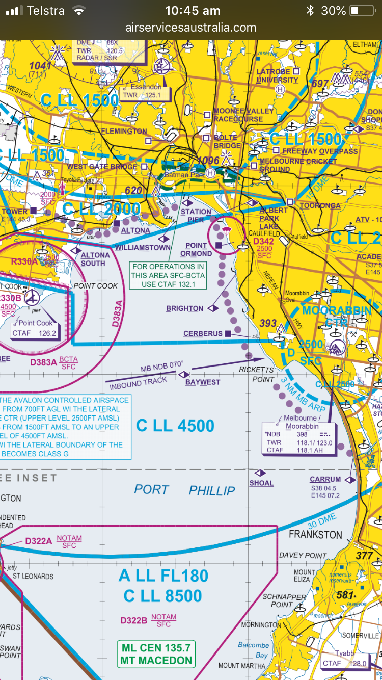
The recommendations carry down past Moorabbin, however the airspace hasn’t changed there. They are expecting you to maintain the same height past Williamstown and down past Moorabbin, even though you’ve got 2,500 then 4,500ft to play with.
Join Date: Mar 2018
Location: Currently: A landlocked country with high terrain, otherwise Melbourne, Australia + Washington D.C.
Posts: 396
Likes: 0
Received 0 Likes
on
0 Posts
Ah, yes, of course.
I just find it awkward approaching BTO from PTOM at 2000 ft if inbound to Moorabbin when first contact is usually made at 1500 ft. That means you'll potentially be in conflicting trajectory with aircraft flying coastal west-/northbound at the same altitude. And even more so because there still seem to be a lot of people at Moorabbin who just aren't aware of these changes yet.
I just find it awkward approaching BTO from PTOM at 2000 ft if inbound to Moorabbin when first contact is usually made at 1500 ft. That means you'll potentially be in conflicting trajectory with aircraft flying coastal west-/northbound at the same altitude. And even more so because there still seem to be a lot of people at Moorabbin who just aren't aware of these changes yet.
Yes, we are. Sorry mate, my brain is still fried from that noise cancelling stopping in mid-flight yesterday.
May 24 version: Fly eastbound/southbound at 1500 ft, westbound/northbound at 2500 ft. No mention to keep to the right of the lane.
Nov 08 version: Fly eastbound/southbound at 2000 ft, westbound/northbound at 1500 ft. With a new mention to track to the right of the lane if [Sunfish's] aircraft is oncoming.
The "direction change" was NOT part of any of the briefings. it is a late change implemented by CASA without any consultation with RAPAC or the OAR. It is believed that the only consultation may have been with the airlines.
CASA were supposed to have had an education programme, but with now less than 2 weeks until implementation there is no sign of any communication programme whatsover from CASA.
RAPAC has called on CASA to defer the change. CASA has rejected this.
On Nov8 anyone flying the East-West coastal route - or doing an "around the bay" joyflight who has not read the detail of the new charts and flies in the direction of 40 years of habit, will be head on at the same level with those that have noticed the text change in the 2 red call-out boxes.
This "change of direction" creates a material risk for a mid-air collision. This decision by CASA together with its failure to conduct any sort of communication programme moves air safety from the realm of good management to good luck.