


Where are you Amelia?


There are many accounts of the disappearance of Amelia Earhart and Frank Noonan during their planned route from Lae PNG to Howland Island in the Central Pacific region. During my time flying 737's with Air Nauru (1976-88) at least three of our routes crossed their presumed track in the region of the then Gilbert Islands now called Kiribati.
Flying at high altitudes we could look down and see the literally thousands of small cumulus clouds dotting the vast ocean from horizon to horizon - each cloud casting a shadow on the water. With their Lockheed flying over the Pacific among those low level clouds where the base of the fair weather CU would be around 1000 ft and tops around 3000 ft, any one of those shadows could be an atoll. It was an illusion of course.
The distance from Lae to Howland Island (itself a tiny atoll albeit with an airstrip) is 2556 statute miles. That's a long way in a small twin engine aircraft not much bigger than a Piper Chieftain and certainly not as fast.
The estimated flight time was between 20 and 23 hours passing through two time zones. It was reported they flew at 12,000 ft some of the way which raises the spectre of mild hypoxia made worse with time at that altitude.
It is after the sun rises, that thousands of small Cu clouds start to appear. Even if only 10 miles off track after 18 hours plus of flight (remarkable navigation for a tired crew) and flying between these clouds, it would have been almost impossible to spot a tiny atoll under its duty Cu among the hundreds surrounding it. Many times I have approached Nauru on descent, unable to spot the island among the low clouds until 15 miles out - keeping in mind we were using the island NDB and DME so we knew where we were
I am not a conspiracy buff and therefore don't believe any other reason for the disappearance of Amelia Erahart's Lockheed other than the limitations they faced. That included sheer mind-blowing fatigue, lack of reliable navigation aids, purportedly no autopilot, the huge distance they set out to fly in a small aircraft to a tiny atoll which was their destination. Add to that the almost impossible task of seeing land under seemingly 8/8ths small separated Cu cloud cover with a base of 1000 ft tops 3000 ft which in that region is typical of Pacific weather at sunrise.
After sunrise in that remote part of the Central Pacific called the Gilbert Islands, every shadow cast by the sun looks like a tiny atoll. With a thousand shadows, which one could be Howland Island to a desperately tired crew?
Last edited by Centaurus; 3rd Jul 2017 at 15:05.
The Dave Billings teams....they were bound for the New Britain jungle in June ?
Hopefully they will find that elusive silver twin as found and noted by the Australian Army patrol during the war.
Fingers crossed !!
Hopefully they will find that elusive silver twin as found and noted by the Australian Army patrol during the war.
Fingers crossed !!

No radar on the Lockheed or at Howland Is. either...unfortunately.
Centaurus...you have seen those things that others have only dreamed of.... in that long delirious blue. And that VAST Pacific.. Sure is an awful lot of water out there !
Seen the shadow trap tho, gave it eta + 15, ignored the many "islands" and headed off to the next place...after some sweaty dr and guesstimates...to the right destination...fortunately. (SE, one radio. lighty)
Frank Noonan was given to be one of the top trans-Pacific navigators of his day, so always figured that he would have had a back up plan if things were not working out.
But what....??? All the way back to Rabaul...I dont think anybody even contemplated the idea. But....
MH 370 has taken it from top billing. I wonder if it is still unfound and talked about 80 years hence.
Nemo Me Impune Lacessit
Join Date: Jun 2004
Location: Derbyshire, England.
Posts: 4,091
Received 0 Likes
on
0 Posts
Last speculation I saw was that Frank Noonan enjoyed a drink and was thought to have 'pushed the boat' out the night before, may well have dropped off to sleep at a critical time and may have forgotten to allow for crossing the IDL when making his calculations and using tables.
Interesting photo but.... pre war plenty of other europeans about..
Would need to see more of the picture to see a Lockheed size whatever. behind the boat, at far right ??
While Frank may have overdone it (true/false) the night before take off...he had plenty of time to recuperate before the following daybreak...and he was a very good navigator.
So there would have been a contingency plan for sure.
I am quite confused and Mayday. Trying to post a picture on this thread as part of the Amelia discussion but going nuts. I use photobucket website which I have done for years. It was always not user friendly but is worse still. I managed to place the selected picture on the photobucket website. But getting it from photobucket to a post on Pprune has proved totally confusing to navigate.  Appreciate any helpful advice.
Appreciate any helpful advice.
Last edited by Centaurus; 6th Jul 2017 at 06:55. Reason: unnecessary.
[URL=http://s2.photobucket.com/user/HSWL/media/Pacific%20ocean%20001_zps0g7r5awe.jpg.html]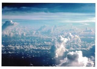 [/URL
[/URL
At last managed to get this photo into Pprune by trial and error and much gnashing of teeth. But couldn't get rid of extraneous text above picture.
They say one picture is worth a thousand words. This is such a picture and taken over the approx track that the Lockheed was estimated to have flown over the Gilbert Islands group of atolls (now Republic of Kiribati) while trying to find Howland Island. Taken from an Air Nauru Boeing 737 circa 1979.
As mentioned before, it is all too easy to imagine how a tired crew after 18 hours of hand flying, could miss Howland Island (only 1.5 miles long) among the plethora of low altitude Cu clouds that are a characteristic of that part of the Pacific after sunrise. Each cloud casts a sun shadow on the surface of the sea that can easily be mistaken for an atoll. There are thousands of these clouds. Take your pick which could be an atoll or an illusion.
[/URLAt last managed to get this photo into Pprune by trial and error and much gnashing of teeth. But couldn't get rid of extraneous text above picture.
They say one picture is worth a thousand words. This is such a picture and taken over the approx track that the Lockheed was estimated to have flown over the Gilbert Islands group of atolls (now Republic of Kiribati) while trying to find Howland Island. Taken from an Air Nauru Boeing 737 circa 1979.
As mentioned before, it is all too easy to imagine how a tired crew after 18 hours of hand flying, could miss Howland Island (only 1.5 miles long) among the plethora of low altitude Cu clouds that are a characteristic of that part of the Pacific after sunrise. Each cloud casts a sun shadow on the surface of the sea that can easily be mistaken for an atoll. There are thousands of these clouds. Take your pick which could be an atoll or an illusion.
Last edited by Centaurus; 6th Jul 2017 at 07:25.
[quoteapparently photobucket have changed their terms so linking photo's to 3rd party sites is restricted to paid subscribers. ][/quote]
Thanks for that info, Scroogee.
Cent
Thanks for that info, Scroogee.
Cent
Join Date: Jun 2001
Location: Rockytop, Tennessee, USA
Posts: 5,898
Likes: 0
Received 1 Like
on
1 Post
Last speculation I saw was that Frank Noonan enjoyed a drink and was thought to have 'pushed the boat' out the night before, may well have dropped off to sleep at a critical time and may have forgotten to allow for crossing the IDL when making his calculations and using tables.
https://earharttruth.wordpress.com/2...he-true-story/
Here's a version of the ending of Noonan's career at Pan Am based largely on a 1972 interview in the PAA archives of fellow crewmembers Victor Wright and Harry Canaday:
Fred Noonan was 'let go' at the end of 1936 for drinking. He was in the words of a fellow crew member sent to the Cincinnati Division. I am assured by a former PAA navigator that that was the euphemism for 'getting the boot.' What is my evidence for this and how credible it that evidence?
In the archives of PAA, in Miami, there exists a series of transcribed interviews between John Leslie, a former PAA executive and several crew from the pioneering days of the Clippers. Two of those crew flew with Fred. They are Victor Wright and Harry Canaday. Both, but particularly Wright tell in no uncertain terms what happened.
Fred developed a severe drink problem after Acapulco where the Clipper stopped during its transfer across country from Miami to Alameda. He suddenly found fame according to Wright and it went to his head. Before this he had been 'rock steady' with no sign of a 'crackup'. He 'did a beautiful piece of work'. Then in Acapulco everyone was shaking his hand. Overnight he became a celebrity, invited to all the parties where he regaled the company with sea faring tales. He was very much in demand and the partying habit continued in Honolulu, Wake, Guam and Manila. One day he had to be sought out by Wright who had to get into some 'interesting situations' and proceeded to sober him up before his flight This resulted in a fall in the bathtub which knocked out his front teeth.Canaday navigated on the way back. One might say that this was 'normal behaviour' for the aviators of the time. Maybe for some but not for PAA.
Andre Priester another executive of the era instantly dismissed anyone under the influence of alcohol. It is a measure of the esteem in which Fred was held that he was tolerated for almost two years. Wright says that the 'Old Man' covered up for Fred. Was that Musick? or Priester? or Trippe? They knew he did a faultless job and he was indispensable for the proving flights. But by the time regular passenger carrying service was set up and other navigators were trained his value waned and he became a liability. The company carried very high class personages from heads of state to movie stars. It simply would not do for them to see the plane's navigator carried aboard comatose. He had to go. But according to Wright, PAA could not lose face by admitting they had employed Fred when he was in this state. They had too much to lose so he simply disappeared from the payroll. That is why there is no official record of him having been dismissed.
Decades later there were similar rumors at Pan Am about the father of the skipper of the ill-fated oil tanker Exxon Valdez.
Also, Paul Mantz was originally planned to be the other crewmember on the fatal Pacific crossing according to some accounts but bailed out of the deal after Earhart's ground loop on takeoff in Hawaii on the earlier Pacific crossing attempt.
Paul Mantz had his own alcohol issues as cited in coverage of his fatal crash while filming a stunt for The Flight of the Phoenix (1965).
The idea of a female aviator setting records for speed and distance in flight has been explored many times in the eight decades since the Earhart-Noonan disappearance by women like Brooke Knapp, Terri Jones and Jeana Yeager.
Join Date: Apr 2009
Location: Oakland, CA
Age: 72
Posts: 427
Likes: 0
Received 0 Likes
on
0 Posts
Yes, I agree, it is easy to imagine this - it is however much, much harder to imagine that after failing to locate Howland Island they mysteriously navigated to Gilbert Islands. Noonan was a very good navigator and such a miss by almost 1000 km makes no sense at all. Further it makes no sense since Amelia's voice was clearly heard in the vicinity (based on the radio technology at the time) of Howland island with minutes of aviation fuel to spare (her panicky voice at the time). She is even heard saying very loudly - we must be on you but can not see you. So assuming, based on preponderance of evidence that at 7:42 they were within 100 nm from Howland Island and the fuel was supposed to last another ~30 minutes - how did they get to Gilbert Islands almost 4 hours flight time away? Makes absolutely no sense.
Last edited by olasek; 10th Jul 2017 at 23:35.
Always wondered why Amelia and Fred didnt go for the 'offset method', as used successfully by Chichester. Go for a point well south and with chronometer and sextant, pick up the north -south/appropriate angle sun line, get an accurate drift as possible and track for the target not so far away. When they missed / couldnt spot Howland /or were not even in visual distance...they had no idea..north or south of ??
Amelia did talk if running on a line ..337-157 was it?..but to and fro where.
There were purportedly other issues, HF freq no. didnt match aerial length no.
Time zones differed, putting call and listen out times to be mismatched.
Batteries for the radio beacon on Howland had been left on overnight and were flat by the morning....
Was the Chronometer off, did the sextant get dropped and damaged...?
And after the greatest aerial search ever.....narry a trace.
So where are you Amelia (and Fred).?
Thread Starter
Of all the experts who have their theories of where Amelia got to, not one of them is thinking like a pilot. Amelia may have not been the best operator of a Lockheed 10 ever, but she was not stupid. She, like any of us, certainly had a "plan B". This was documented to turn back the the Gilbert Islands, 600 miles north to south, a bit hard to miss, find one with a decent sized village, ditch in the water, on the reef, in the scrub and wait for the US navy to find her.
But just suppose she had run into strong headwinds, had been hundreds of miles short of Howland and tried, after getting a fix, either at the Gilbert Islands or with sun sights, and, commercial pressures here, tried to make it back to Rabaul at best endurance speed and a reasonable tailwind. At full fuel her aircraft had a documented range of 4,000 miles and she had talked to Lindberg and also worked with P and W on extended range operations.
She could feasibly made it to New Britain or one of the offshore islands before dark. We will, of course, probably never know.
Join Date: Apr 2009
Location: Oakland, CA
Age: 72
Posts: 427
Likes: 0
Received 0 Likes
on
0 Posts
I think it is a poor choice of words to think of her in terms stupid/smart. She clearly did not do a very smart thing when she overruled her navigator and chose to turn in the wrong direction when approaching Africa - contrary to Fred's advice. It is impossible to miss Africa so it did not have and bad consequences. This mishap is well documented and almost made Fred walk away from this endeavor. He must have realized that he is there only for a ride and his work may not be taken seriously. This could be what happened at the end (as suggested by some historian, not my invention) - his precise navigation instructions were disregarded around Howland Island and this time there was no way out.
I agree with olasek, she would have been close to her destination at the time she ran out of fuel and crashed / lost altogether. In my view those that believe otherwise are the same conspiracy theorists that believe Elvis is still alive or man never walked on the moon.