Old maps/pictures


Thread Starter
Join Date: Jun 2010
Location: International Space Station
Posts: 68
Likes: 0
Received 0 Likes
on
0 Posts
I still have all my WAC charts from GA days.
I also have a RAAF mercator chart from WW2,a first edition WAC chart for TAS and an early style NDB chart/Landing Chart for Portland from '66.
I also have a RAAF mercator chart from WW2,a first edition WAC chart for TAS and an early style NDB chart/Landing Chart for Portland from '66.

If your trying to upload pics you could always post it on tinypic.com then post the link?

Notice the ALA's at Lillydale, Tyabb, Berwick and Tooradin aren't shown.
What is the ALA shown on the northern side of the train line running down to Wonthaggi?
What is the ALA shown on the northern side of the train line running down to Wonthaggi?
S8....That was,I think Catani. It was abandoned by the late 50's . I suspect it was only used as a satellite/emergency strip.
It can still be seen on Google earth if you look in the right spot.
With the exception of Berwick. the other strips you mention did not exist in the late 50's. At that time pretty near all the aerodromes in use were either early DCA or wartime aerodromes.
Emeritus
It can still be seen on Google earth if you look in the right spot.
With the exception of Berwick. the other strips you mention did not exist in the late 50's. At that time pretty near all the aerodromes in use were either early DCA or wartime aerodromes.
Emeritus
Join Date: Aug 2003
Location: Sale, Australia
Age: 80
Posts: 3,832
Likes: 0
Received 0 Likes
on
0 Posts
Posted on behalf of emeritus.
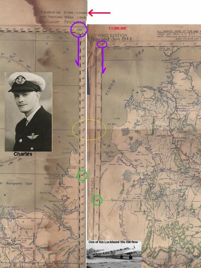
Hobart Chart is dated Sept 1955, Darwin chart Dad souvineered this during the war. He was ground crew in a RAF spitfire sqn and they used to deploy to Truscott and Kalumbaru on a rotating basis as the Japs used to cross the coast SW of DRW to avoid the DRW defences.


Hobart Chart is dated Sept 1955, Darwin chart Dad souvineered this during the war. He was ground crew in a RAF spitfire sqn and they used to deploy to Truscott and Kalumbaru on a rotating basis as the Japs used to cross the coast SW of DRW to avoid the DRW defences.
Join Date: Feb 2005
Location: Brisbane
Posts: 374
Likes: 0
Received 0 Likes
on
0 Posts
When I get a chance I'll scan a couple of mine.
The one to the west of that Darwin chart above was a different scale .... something like 1: 1,3000,000.
I looked into that discrepency when a couple of us were rehashing the reasons for a Guinea Airways Lockheed14 crash near Pine Creek during the war. The aircraft flew close to the edge of the charts and there could have been a lot of confusion with mapreading in a dark cockpit in the blacked out North... Japs had done some visiting on a number of occasions recently.
It's a great example of blaming the captain... he's dead.
They conveniently swept the investigation under the carpet of wartime secrets which were released about five years ago.
It was a perfect example of chain of events or holes in the cheese, where many living made a silly little mistake and twelve men died.
Basically, the aircraft took off at Archerfield at 0622EST and ploughed in with almost empty tanks in rain and thunderstorms while trying to do a crash landing in the dark at 2128 CST. Yeah! they'd landed three times to refuel on the way. The second pilot had done 135, 127 and 107 hours in the previous months. 'Wartime you see'.
They got a lot of wrong information that had everybody certain they were flying back and forward over Darwin when they were over a hundred miles away.
Emeritus,
According to my 1945 RAAF Aerodrome Guide that's Monomeith.
According to my 1945 RAAF Aerodrome Guide that's Monomeith.
Folks,
Not quite maps and charts, but I have a pristine copy of the 1937 Air Navigation Regulations complete, runs to all of about 30 or so pages --- bought at auction, including the receipt and name of the original purchaser, the receipt for the grand sum of two shillings and sixpence.
I showed then to Bruce Byron on one occasion, with the suggestion that the thousands of pages of regulations we now have, have not made any material difference to air safety.
In fact, there is scant evidence that the ballooning of the volume of the regulations has the slightest effect on air safety outcomes, except for stiffing of aviation activity and growth ----- if you ain't flying, you ain't going to have an air accident, are you??
Tootle pip!!
Have on my wall at home a map from the 1930's air race England to Australia. Included with it are all the names of the entrants with someone crossing out those who didn't finish. I'll try and post a copy tomorrow.
Sounds like it was called Monomeath. I always referred to it as Catani for some unknown reason. It is slightly closer to Monomeath.
For those interested its co ords are
S38 deg, 12' 48.79"
E 145deg, 34' 00.54"
It is still visible, but only just, on Google Earth.
Emeritus.
For those interested its co ords are
S38 deg, 12' 48.79"
E 145deg, 34' 00.54"
It is still visible, but only just, on Google Earth.
Emeritus.
Sixtiesrelic...
Interesting comment on the scale. I checked the chart and it is 1:1,000,000 however I had never noticed that the scale on the LHS is in kilometers !
Why in hell would the mapping people do that?
Great way to set someone up.
Brian Abrahams...
Thanks muchly for posting. Will someday get around to sorting out posting.
Emeritus
Thread Starter
Join Date: Jun 2010
Location: International Space Station
Posts: 68
Likes: 0
Received 0 Likes
on
0 Posts
It is still visible, but only just, on Google Earth.
anyone know the coordinates of the old french island ALA?