


iPhone apps for Pilots


New app for testing
Hi Folks
We are in the process of writing a flight planning iPad app and need a few patient people with an iPad running iOS 4.2 to do some usability and functional testing.
If anyone is interested, contact me via PM.
Thanks,
Bevan..
We are in the process of writing a flight planning iPad app and need a few patient people with an iPad running iOS 4.2 to do some usability and functional testing.
If anyone is interested, contact me via PM.
Thanks,
Bevan..
I also assume that doing this in-app, bypasses apple??
Apple have now abused their dominant market position by forcing every single app that offers an external subscription, to also offer an internal (in-app) subscription. Developers have a couple of months to comply.
This means that if somebody buys a years subscription from a company's website, then the company will get all the money. However they must also offer an in-app purchase option for the same price (or less). If the user buys the Subscription in-app, then Apple automatically get 30%.
And guess which one people will do - the easier in-app one. Doesn't go well with a lot of content providers and there are already talks of anti-trust lawsuits against Apple, kind of like how Microsoft abused their market position.
I assume that we pay you when the month period runs out?
I think we're close to getting some clarification from CASA. I've tracked down the guy in charge of developing EFB policy & awaiting his response. Hopefully Australia copies the FAA policy of allowing EFB's for all small, non-commercial aircraft at the Captain's discretion.

Join Date: Aug 2009
Location: Australia
Posts: 632
Likes: 0
Received 0 Likes
on
0 Posts
OzRunways 2.0 out!
Blowing my own horn here, hope you don't mind... Shagpile, SeaMoss and I have just released OzRunways 2.0.

More info here:
OzRunways EFB 2.0. Know where you�re going. And how to get there. | OzRunways
More info here:
OzRunways EFB 2.0. Know where you�re going. And how to get there. | OzRunways
 good work u blokes.
will try out over the weekend.
have been using air nav pro for 6m or so(very good), but would much prefer to buy Oz Made!
Will be glad to do some app consolidation too... Trying to copy clearances while listening to chili peppers while reading my emails while flicking between NAIPS, OZrunways, Airnav and Angry Birds was stressing me out.....

BE
Shagpile,
Just wondering if it's possible to download all the maps etc. through a computer rather than the iPhone. I don't have access to Wifi and I don't really fancy using up all my Data allowance for the month.
Cheers
morno
Just wondering if it's possible to download all the maps etc. through a computer rather than the iPhone. I don't have access to Wifi and I don't really fancy using up all my Data allowance for the month.
Cheers
morno
.. in the spirit of free plugs, if you want flight planning on your iThingie, this app is awaiting approval from our friends at apple;
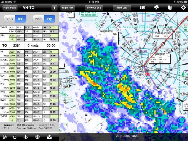
Full NAIPS integration, ERSA, AIP, DAPS and all maps with some nifty weather radar overlays. Build a complete flight plan by pointing and clicking. More details on our site
Should be available in the next week or so from the App Store.
Bevan..
Full NAIPS integration, ERSA, AIP, DAPS and all maps with some nifty weather radar overlays. Build a complete flight plan by pointing and clicking. More details on our site
Should be available in the next week or so from the App Store.
Bevan..
Join Date: Aug 2009
Location: Australia
Posts: 632
Likes: 0
Received 0 Likes
on
0 Posts
Just wondering if it's possible to download all the maps etc. through a computer rather than the iPhone. I don't have access to Wifi and I don't really fancy using up all my Data allowance for the month.
So the computer you intend to use is connected to the internet? Does that have WiFi? If not, buy a cheap USB wifi adapter. Then turn on internet sharing via the wifi interface and connect your iPendix to it.
Join Date: Jan 2009
Location: Australia
Posts: 201
Likes: 0
Received 0 Likes
on
0 Posts
Originally Posted by Bevan666
.. in the spirit of free plugs, if you want flight planning on your iThingie, this app is awaiting approval from our friends at apple;
Also, what's the subscription cost?
This looks fantastic - highly polished, and will be the tipping point for me in buying an iPad 2 this week! Can you confirm just what the level of integration is with it? No need to enter distances, tracks etc to each waypoint manually I assume, it works them out for you? Does it autofill wind info from NAIPS also?
Enter a departure time, some people, fuel and then submit the plan via NAIPS. If you love paper you can print the plan + ERSA/DAP charts for your route with the press of a button.
Job done.

Then in the aircraft in flight the <previous leg> <next leg> buttons can be used to set which leg of your plan you are on. As waypoints are passed the times are logged, and ETA's for the rest of the plan updated based on forecast winds.
When pressing on a leg on the flight plan another window opens with the TAF's and NOTAMS for that location, and scrolling to the right you have the ERSA and DAP's for the location (if applicable).
As for pricing, the various subscription types are on our site, but the full version with ERSA,AIP,DAPs and all maps for a year will be $130 when purchased through our site or $170 via the subscription in the app store.
Bevan..
Bevan, does it allow you to create and save user "airports"? Most places I go to are not airports and as such don't appear in any DAFIF etc.
I am looking for an app that will let me save the lat lon a bunch of user airports and flight plan between them (dist, trk in �True).
These airpots are not (technically) in Aus so would that matter (bearing in ming that I'm not interested in viewing the maps....) ?
I am looking for an app that will let me save the lat lon a bunch of user airports and flight plan between them (dist, trk in �True).
These airpots are not (technically) in Aus so would that matter (bearing in ming that I'm not interested in viewing the maps....) ?

Bevan, does it allow you to create and save user "airports"? Most places I go to are not airports and as such don't appear in any DAFIF etc.
Bevan..
Great. And can you name them and save them whatever you like?
Also, will it work/output in degrees true? (a small market segment I know... .)
.)
And as a final thought, can you upload your own georeferenced maps? This might not be a niche market segment as I think the fire crews have their own georeferenced maps. Some fire crews might like to confirm....
Also, will it work/output in degrees true? (a small market segment I know...
.)And as a final thought, can you upload your own georeferenced maps? This might not be a niche market segment as I think the fire crews have their own georeferenced maps. Some fire crews might like to confirm....
All its internal calculations are in true, then a local magnetic variation is applied when a track/ heading is displayed to the user. In this release there is no switch to turn that off to leave everything in degrees true, but it can be added before the summer.
As for user maps - a user cant do that in this release, but its a good idea though.
Bevan..
As for user maps - a user cant do that in this release, but its a good idea though.
Bevan..
Join Date: Dec 2000
Location: Sydney NSW Australia
Posts: 3,051
Likes: 0
Received 0 Likes
on
0 Posts
thses apps have made the decision for me, i was looking at installing a Garmin Aera 550 soon, but have now bought an ipad2, cheaper, more usefull at home apart from the moving map apps, and i still have my GPS96C as backup.
Apart from the small screen, anygood on the Iphone or do you really need the Ipad?
Bevan..