


Alleged UFO or UAP, 1990, Calvine, Scotland

200m of level grass (Landrover @30kts test) with a CBR (Californian Bearing Ratio) of 2.5 at 6” increasing, will make a decent Harrier strip. Somewhere in a land far away, I pogo-sticked myself across more fields than I care to remember. Still say that this is all a figment though.
Mog
Mog

200m of level grass (Landrover @30kts test) with a CBR (Californian Bearing Ratio) of 2.5 at 6� increasing, will make a decent Harrier strip. Somewhere in a land far away, I pogo-sticked myself across more fields than I care to remember. Still say that this is all a figment though.
Mog
Mog

I stand to be corrected but I think that these Harrier strips were in established military training areas / danger areas which is where you would choose to do something secret. Calvine / Glen Tilt is not such an area.
Thread Starter
Re: the suggestion that there was a temporary airfield constructed at or near Glen Tilt in Perthshire in the late 80s or early 90s (operational certainly in 1990):
For the Harrier people here, did you ever operate from a strip outside a military training area or hear of US aircraft doing so in the UK?
Thank you.
For the Harrier people here, did you ever operate from a strip outside a military training area or hear of US aircraft doing so in the UK?
Thank you.
Thread Starter
Hi Everyone,
A big thank you to all who contributed on here, and additional gratitude to those who emailed me privately with additional information.
The Disclosure Team's YouTube channel will be revealing a video that should interest those of you who are into this case.
Also, there's a Daily Mail article which kind of spills the beans in its title:
https://www.mailplus.co.uk/edition/f...-ever-captured
Cheers
Last edited by Senior Pilot; 12th Aug 2022 at 20:35. Reason: Fix link
Why does this nonsense still drag on? Nothing fits, nor is anything independently verifiable.!
Embarrasingly naive!
Embarrasingly naive!
Last edited by Haraka; 12th Aug 2022 at 18:37.
Thread Starter
Cheers Grifo! It was a good chase. At times we thought we'd never get there but we persisted and thankfully prevailed (with the photo at least)!
Have you tracked down the ac in the background, which in the picture in the Mail, looks more like a Hunter than a Harrier?
Thread Starter
No, we drew a blank on that one unfortunately. It's a possibility, certainly, but others are equally insistent it's a Harrier, so that's still a mystery.
We've also tried everywhere we could think to look to find NOTAMs, but no one seems to have preserved any.
Cheers
We've also tried everywhere we could think to look to find NOTAMs, but no one seems to have preserved any.
Cheers
Seriously, Do you really think that this wouldn't have leaked from FJ aircrew after all these years?
Last edited by Haraka; 13th Aug 2022 at 08:26.
Haraka,
It does not matter the amount of evidence, or lack of, that is presented, like flat-earthers nothing will shake their conviction that there is an official cover-up or conspiracy.
It does not matter the amount of evidence, or lack of, that is presented, like flat-earthers nothing will shake their conviction that there is an official cover-up or conspiracy.
😜YS
It�s a picture of a rock or island in a loch with its reflection and that of a jet (probably a Hunter) flying over, probably slightly under exposed to take the detail out. Nicely done but as real as all those Nessie photos.
Nah, it is a tiny shard of glass, probably from the reflex mirror. It just looks large, and in focus due to the contact with the lens face.
Obviously he could be lying, but the combination of getting this photo and then having the military disappear it for decades is provocative.
Join Date: Dec 2013
Location: UK
Posts: 22
Likes: 0
Received 0 Likes
on
0 Posts
I did some analysis: Someone overlaid part of the photo with the view that is claimed the point the photo was taken from. Here is the brief Youtube video. It's bang on. Yes the fence posts aren't quite inline, but it's as near as anyone will get:
Here's a still frame I got from the Metabunk thread on the same subject (from the same video) because I'm lazy - I've cropped that still video image for size:

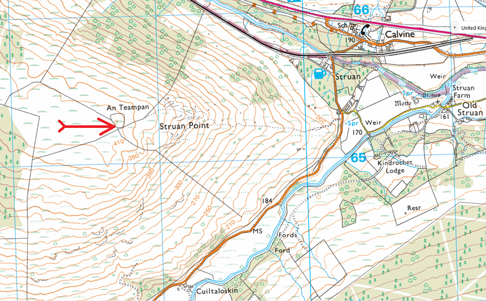
The point the photo is claimed to have been taken from is here - note the copse, which would match the trees in the above shot. NB: An Teampan is 415m above sea level:
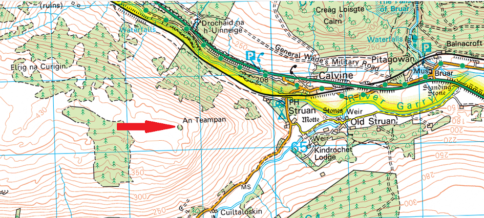
Here is a more detailed OS shot of the same area. Big red arrow points close to the copse and fence. Note the dotted line which is the path up to An Teampan past Struan point from Struan and the road. The description of the two Chefs walking up through a forest matches as there was once a plantation on that slope. You can see the lines on google maps/earth where the trees once were. Also note the solid black lines which are fences - that also matches the fence in the Youtube shot.:
If you go to An Teampan (56 45 46N 3 59 07W) on google earth and play around you can find the direction of the image in the Youtube video - the POV in the image below is clearly higher at 440m than the original point (415m), but you can see the same features which I've labelled. Obviously the farm (Auchanruidh) in the valley and between the forestry track and Allt F�ith a' Chabair cannot be seen from the lower photo POV. You can also see the fences around the copse and others, which match the above OS map:
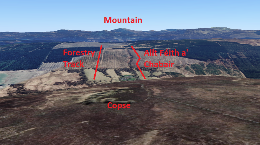
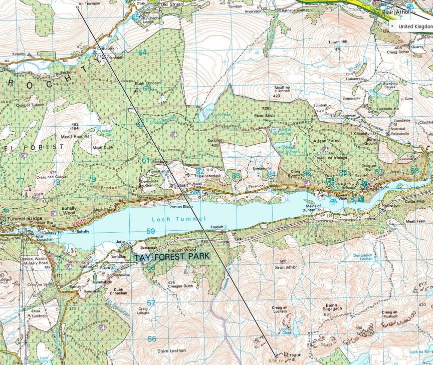
If you follow Allt F�ith a' Chablair, which is a stream/burn, towards the mountain, you find the mountain is Farragon Hill at 783m and 7 miles away from the point the Youtube still is taken from, which is from the video of the researchers earlier in the thread:
I think everything matches up. There's a lot of info and images in this post so I'll leave it there and comment on another post.
Here's a still frame I got from the Metabunk thread on the same subject (from the same video) because I'm lazy - I've cropped that still video image for size:
The point the photo is claimed to have been taken from is here - note the copse, which would match the trees in the above shot. NB: An Teampan is 415m above sea level:
Here is a more detailed OS shot of the same area. Big red arrow points close to the copse and fence. Note the dotted line which is the path up to An Teampan past Struan point from Struan and the road. The description of the two Chefs walking up through a forest matches as there was once a plantation on that slope. You can see the lines on google maps/earth where the trees once were. Also note the solid black lines which are fences - that also matches the fence in the Youtube shot.:
If you go to An Teampan (56 45 46N 3 59 07W) on google earth and play around you can find the direction of the image in the Youtube video - the POV in the image below is clearly higher at 440m than the original point (415m), but you can see the same features which I've labelled. Obviously the farm (Auchanruidh) in the valley and between the forestry track and Allt F�ith a' Chabair cannot be seen from the lower photo POV. You can also see the fences around the copse and others, which match the above OS map:
If you follow Allt F�ith a' Chablair, which is a stream/burn, towards the mountain, you find the mountain is Farragon Hill at 783m and 7 miles away from the point the Youtube still is taken from, which is from the video of the researchers earlier in the thread:
I think everything matches up. There's a lot of info and images in this post so I'll leave it there and comment on another post.