


US Navy’s new unhackable GPS alternative.

Seen them a few times - always worth looking after dusk or before dawn if it's really clear - quite ethereal

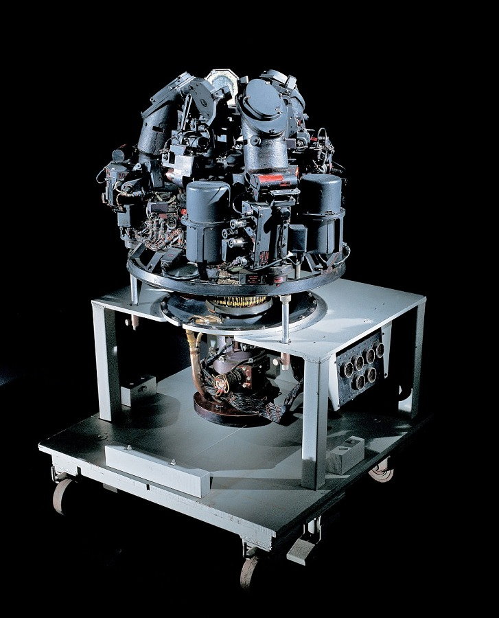
First electro-optical astro-inertial system was developed for the Northrop SM-62 Snark, starting in the late 1940s. Airborne star acquisition and tracking was demonstrated around 1952. Snark of course was cancelled but Northrop built the Blackbird's system and that for the B-2. Kollsman developed an astro-tracker integrated into the B-58's NAS, and the Skybolt missile had one built into the pylon to update the INS immediately before launch. There is a Snark system in the Udvar-Hazy.
Astrotrackers
First electro-optical astro-inertial system was developed for the Northrop SM-62 Snark, starting in the late 1940s. Airborne star acquisition and tracking was demonstrated around 1952. Snark of course was cancelled but Northrop built the Blackbird's system and that for the B-2. Kollsman developed an astro-tracker integrated into the B-58's NAS, and the Skybolt missile had one built into the pylon to update the INS immediately before launch. There is a Snark system in the Udvar-Hazy.
Perhaps advances in inertial platforms and solid state electronics has enabled improved accuracy, reliability and maintenance costs.
Salute!
Where have you flown recently, Global?
The inertial platforms since the late 70's have demonstrated a mile per hour drift on high performance fighters that introduce many more gees and turn rates and... than your basic 747 cruising level for 10 hours. So a good position update can really help things.
The Trident system had super inertial sensors, but the big thing was the mid course position update using a star. The clever Draper folks used that for basic position, but also to calibrate the inertial. The system did not need constant updates or signals from a GPS sat.
If the Navy or Draper says a system can find a star in broad daylight, I tend to believe them. I agree that heavy clouds and such are a biggie, so a system they are talking about should not be the most inportant nav system for ultimate mission success. One thing you can do nowadays that was not possible 50 years ago is reset your strapdown or RLG inertial at last known position, then apply corrections to the inertial sensors.
I like the idea of a system that is independent of the sats. I might also add that one platform I flew long ago used a doppler system to "help" the inertial. There may be fairly simple sensors to help a good inertial provide very accurate positional and body rates.
Gums sends...
If the Navy or Draper says a system can find a star in broad daylight, I tend to believe them
 A hot alignment took 18 minutes, cold 36 minutes, exclusive of warm up time. A scramble would of course require an inflight alignment. Catalogue had data for 61 stars, sun, moon and planets were excluded. Until the star tracker had a lock nav was by inertial.

Salute!
Thank you, Megan.
I only know two Blackbird pilots, so I cannot confirm their astrotracking doofer.
The "newer" systems I worked with a bit over twenty years ago watered my eyes. The strapdown inertial for AMRAAM aligned in seconds and could get you within a hundred yards in one minute of manuevering flight.
I really like the idea of using something beside the GPS stuff.
Gums sends...
"The strapdown inertial for AMRAAM aligned in seconds and could get you within a hundred yards in one minute of manuevering flight."
What was the drift over a few hours GUMS?
In my experience the advantage of GPS is no drift, nor worry about being able to see the stars, constant updates
What was the drift over a few hours GUMS?
In my experience the advantage of GPS is no drift, nor worry about being able to see the stars, constant updates
Talking to a Habu who was giving a talk on the jet, I asked how good the astrotracker was at aligning at Mildenhall under cloudy skies with East Anglian low stratus off the North Sea....
"Not very!" was his answer! But once R2D2 could sniff out the stars up at FL nosebleed even at Mach lots, it was VERY good!
"Not very!" was his answer! But once R2D2 could sniff out the stars up at FL nosebleed even at Mach lots, it was VERY good!
Salute!
Yeah, Astur, prolly a nm per hour or less. Of course, it only had to get the missile within x yards after 30 seconds, and it was being used for a cluster bomb guidance system on a new system.
The reason I mentioned it was the technology advancements since the first large scale use of inertials and then the development of strapdown systems. The alignment times decreased by an order of magnitude. So way I see it is tonight I could lay my iPhone down next to me at the campsite and it would look at the stars and compare with my Starmap program and then compute.
I just have bad waves about a major conflict where the other side could disable or degrade the existing GPS system enough to cause big problems.
Gums sends...
it would look at the stars and compare with my Starmap program and then compute.
I agree that reliance on an active transmission is inherently a bad idea.
Ecce Homo! Loquitur...
Not sure if this all ties just into OneWeb or also the US PNT systems*……
http://bidstats.uk/tenders/2021/W13/747897237
https://www.gov.uk/guidance/space-based-pnt-programme
https://www.cityam.com/oneweb-in-tal...-to-rival-gps/
* https://www.c4isrnet.com/battlefield...-of-september/
* https://www.militaryaerospace.com/se...natives-to-gps
http://bidstats.uk/tenders/2021/W13/747897237
https://www.gov.uk/guidance/space-based-pnt-programme
https://www.cityam.com/oneweb-in-tal...-to-rival-gps/
* https://www.c4isrnet.com/battlefield...-of-september/
* https://www.militaryaerospace.com/se...natives-to-gps
"the alignment times decreased by an order of magnitude. ""
I remember it well - and the nagging fear that the drift on YOUR unit was one of the outliers on the curve............
Of course the old methods were'nt foolproof. I know of someone who set off to cut a 50 km path through a rain forest and dialed in the magnetic deviation on their survey gear on the "wrong" side". Only found out when they arrived, several weeks later, on a river 50+ kms away - several kms off plan...........
Of course the old methods were'nt foolproof. I know of someone who set off to cut a 50 km path through a rain forest and dialed in the magnetic deviation on their survey gear on the "wrong" side". Only found out when they arrived, several weeks later, on a river 50+ kms away - several kms off plan...........
I've worked in West Irian and Kalimantan and that story doesn't surprise me at all - if you live in those god-forsaken forests you must develop skills us incomers have no idea of..................
In Absence of GPS.....eLoran To The Rescue?
In this month's US Naval Institute monthly magazine is an article about the need for a ground based replacement for Space based GPS navigation and Time Signalling in the event of War breaking out.
The Russian doctrine assumes all Space based systems shall be made Combat In-effective and are taking measures to provide backup systems.
Traditionally, the US Coast Guard provides navigational systems for the US DOD and ran the legacy LORAN-C system for Fifty Two Years before ending that program in 2010.
There is a proposal for the creation of a new eLORAN system to be operated by the USCG among requirements that it be deployable to combat areas when needed to replace losses of GPS coverage.
The article reports the Russians have used GPS disruption tactics in Syria and the US Military has also done similar actions at various times.
If Western Militairs, including the RAF and RN along with the US Forces were to lose all use of GPS Navigation services and its knock on uses.....are we prepared for that contingency?
Is eLORAN needed?
Are the Russians and Chinese ahead of the West as stated in the Proceedings Article?
Where is the advantage?
Along with eLORAN.....might we see a return of something called eDECCA?
or....CONSOL Radio Systems?
or....CONSOL Radio Systems?
Youngsters these days have no map reading skills. They rely on GPS to get where they are going, whether it is a satnav or more likely, their phone.
Admittedly they are very good at finding places using them, but going back to basics might prove a challenge for most of them.
Admittedly they are very good at finding places using them, but going back to basics might prove a challenge for most of them.