


Cruise Missiles TERCOM

Thread Starter
Cruise Missiles TERCOM
as I understand it cruise Missiles like the BGM 109G were able to navigate using TERCOM
This required a radar altimeter - wasn't this a trackable source when they were in flight?
This required a radar altimeter - wasn't this a trackable source when they were in flight?

That would depend upon what kinds of sensors were being used, and where those sensors were. Given that those missiles are still in service, I doubt very much anyone is interested in elaborating on that. Why are you asking?

I don't own this space under my name. I should have leased it while I still could
What I can add to LWs reply based on articles probably 30 years ago, TERCOM worked by updating its system in a fix box. The box would be of finite length and sensors only need to radiate in the box.
As crucial to the missiles system was mapping accuracy. In the mid-80s global mapping was at 100 m intervals. For fix boxes they needed 10 m. The aim then was to improve global data to 10 m. The last I heard was that it was considerably better than that. You can see that the improvement from 100 to 10 was an increase of 100 times. To 1 m an increase of 10,000 times.
As crucial to the missiles system was mapping accuracy. In the mid-80s global mapping was at 100 m intervals. For fix boxes they needed 10 m. The aim then was to improve global data to 10 m. The last I heard was that it was considerably better than that. You can see that the improvement from 100 to 10 was an increase of 100 times. To 1 m an increase of 10,000 times.
Last edited by Pontius Navigator; 26th Nov 2018 at 18:34.
Ecce Homo! Loquitur...
Unlike TFR, TERCOM was not transmitted ahead and therefore did not give a target for SAW. Similarity it could not be ujammed causing a sudden pull-up from low level. Yes, the radalt had to transmit straight down, but the power and footprint was minuscule and, practically, undetectable.

OAP
I don't own this space under my name. I should have leased it while I still could
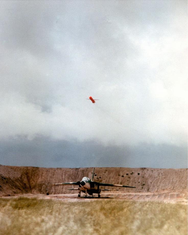
Part of my post relates to an Aviation Leak article and I think on the cover was the image of a cruise missile detonating over an F105 in a revetment on a test range.
Ecce Homo! Loquitur...
PN, IRRC they have several shaped charges so they can overfly several revetments and destroy an aircraft in each, then the airframe pulls up and performs a terminal dive into another to finish its mission.

Join Date: Jul 2007
Location: Germany
Posts: 1
Likes: 0
Received 0 Likes
on
0 Posts
Google helps.... ")
https://en.wikipedia.org/wiki/Tomaha...le)#Navigation
DSMAC has also been used to bring the CEP down on SDB I believe, without expensive INS or GPS equipment. Its an optical pattern matching system that uses cheap as chips COTS to provide a funky guidance system to lumps of metal and explosives.
https://www.globalsecurity.org/milit...ons/damask.htm
As to TERPROM, a few flavors.
Of course, copy n paste off of Wiki, so could quite easily all be b*llocks.
https://en.wikipedia.org/wiki/Tomaha...le)#Navigation
TERCOM – Terrain Contour Matching. A digital representation of an area of terrain is mapped based on digital terrain elevation data or stereo imagery. This map is then inserted into a TLAM mission which is then loaded onto the missile. When the missile is in flight it compares the stored map data with radar altimeter data collected as the missile overflies the map. Based on comparison results the missile's inertial navigation system is updated and the missile corrects its course. TERCOM was based on, and was a significant improvement on, "Fingerprint," a technology developed in 1964 for the SLAM.[29]
DSMAC – Digital Scene Matching Area Correlation. A digitized image of an area is mapped and then inserted into a TLAM mission. During the flight the missile will verify that the images that it has stored correlates with the image it sees below itself. Based on comparison results the missile's inertial navigation system is updated and the missile corrects its course.
DSMAC – Digital Scene Matching Area Correlation. A digitized image of an area is mapped and then inserted into a TLAM mission. During the flight the missile will verify that the images that it has stored correlates with the image it sees below itself. Based on comparison results the missile's inertial navigation system is updated and the missile corrects its course.
https://www.globalsecurity.org/milit...ons/damask.htm
DAMASK was developed and tested at NAWCWD as part of a two-year Fleet Advanced Demonstration funded by the Office of Naval Research (ONR). The purpose was to demonstrate that laser-guided bombs (LGBs) can be replaced with image-guided bombs. Such a replacement will have the benefits of comparable accuracy without the necessity and the risk of an aircraft loitering on-site to guide the weapon to its target. Additionally, the image-guided weapon will have through-the-weather capability.
Optical contour matching[[url=https://en.wikipedia.org/w/index.php?title=TERCOM&action=edit§ion=2]edit]
The Goodyear Aircraft Corporation ATRAN (Automatic Terrain Recognition And Navigation) system for the MGM-13 Mace was the earliest known TERCOM system. In August 1952, Air Materiel Commandinitiated the mating of the Goodyear ATRAN with the MGM-1 Matador. This mating resulted in a production contract in June 1954. ATRAN was difficult to jam and was not range-limited by line-of sight, but its range was restricted by the availability of radar maps. In time, it became possible to construct radar maps from topographic maps.
Preparation of the maps required the route to be flown by an aircraft. A radar on the aircraft was set to a fixed angle and made horizontal scans of the land in front. The timing of the return signal indicated the range to the landform and produced an amplitude modulated (AM) signal. This was sent to a light source and recorded on 35 mm film, advancing the film and taking a picture at indicated times. The film could then be processed and copied for use in multiple missiles.
In the missile, a similar radar produced the same signal. A second system scanned the frames of film against a photocell and produced a similar AM signal. By comparing the points along the scan where the brightness changed rapidly, which could be picked out easily by simple electronics, the system could compare the left-right path of the missile compared with that of the pathfinding aircraft. Errors between the two signals drove corrections in the autopilot needed to bring the missile back onto its programmed flight path.Altitude matching[[url=https://en.wikipedia.org/w/index.php?title=TERCOM&action=edit§ion=3]edit]
Modern TERCOM systems use a different concept, based on the altitude of the ground the missile files over and comparing that to measurements made by a radar altimeter. TERCOM "maps" consist of a series of squares of a given size. Using a smaller number of squares saves memory, at the cost of decreasing accuracy. A series of such maps are produced, typically from data from radar mapping satellites. When flying over water, contour maps are replaced by magnetic field maps.
As a radar altimeter measures the distance between the missile and the terrain, not the absolute altitude, the important measure in the data is the change in altitude from square to square. The missile's radar altimeter feeds measurements into a small buffer which periodically "gates" the measurements over a period of time and averages them out to produce a single measurement. The series of such numbers held in the buffer produce a strip of measurements similar to those held in the maps. The series of changes in the buffer is then compared with the values in the map, looking for areas where the changes in altitude are identical. This produces a location and direction. The guidance system can then use this information to correct the flight path of the missile.
During the flight to the target the accuracy of the system has to be enough only to avoid terrain features. This allows the maps to be relatively low resolution in these areas. Only the portion of the map for the terminal approach has to be higher resolution, and would normally be encoded at the highest resolutions available to the satellite mapping system.TAINS[[url=https://en.wikipedia.org/w/index.php?title=TERCOM&action=edit§ion=4]edit]
Due to the limited amount of memory available in mass storage devices of the 1960s and 70s, and their slow access times, the amount of terrain data that could be stored in a missile-sized package was far too small to encompass the entire flight. Instead, small patches of terrain information were stored and periodically used to update a conventional inertial platform. These systems, combining TERCOM and inertial navigation, are sometimes known as TAINS, for TERCOM-Aided Inertial Navigation System.Advantages[[url=https://en.wikipedia.org/w/index.php?title=TERCOM&action=edit§ion=5]edit]
TERCOM systems have the advantage of offering accuracy that is not based on the length of the flight; an inertial system slowly drifts after a "fix", and its accuracy is lower for longer distances. TERCOM systems receive constant fixes during the flight, and thus do not have any drift. Their absolute accuracy, however, is based on the accuracy of the radar mapping information, which is typically in the range of meters, and the ability of the processor to compare the altimeter data to the map quickly enough as the resolution increases. This generally limits first generation TERCOM systems to targets on the order of hundreds of meters, limiting them to the use of nuclear warheads. Use of conventional warheads requires further accuracy, which in turn demands additional terminal guidance systems.Disadvantages[[url=https://en.wikipedia.org/w/index.php?title=TERCOM&action=edit§ion=6]edit]
One disadvantage of early TERCOM systems was that, due to the limitations of storage and computing systems of the time, the entire route had to be pre-planned, including its launch point. If the missile was launched from an unexpected location or flew too far off-course, it would never fly over the features included in the maps, and become lost. The INS system can help in this regard, allowing it to fly to the general area of the first patch, but gross errors simply cannot be corrected. This made early TERCOM based systems much less flexible than more modern systems like GPS, which can be set to attack any location from any location, and do not require any sort of pre-recorded information which means they can be targeted immediately prior to launch.
The availability of compact fast computers and high-capacity storage, combined with the availability of global digital elevation maps, has mitigated this problem, as TERCOM data is no longer limited to small patches, and the availability of side-looking radar allows much larger areas of landscape contour data to be acquired for comparison with the stored contour data.

Cheers
OAP
I don't own this space under my name. I should have leased it while I still could
ORAC, this was a test round and very early in the program.
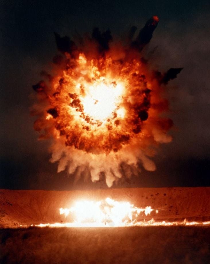
OAP. ha ha. See above. This was when dumb bombs predominated and LGB were pretty new too. What was significant at the time was that the TLAM, travelling at between 400-600 kts, had a fully developed fireball directly over the target.
OAP. ha ha. See above. This was when dumb bombs predominated and LGB were pretty new too. What was significant at the time was that the TLAM, travelling at between 400-600 kts, had a fully developed fireball directly over the target.
I don't own this space under my name. I should have leased it while I still could
Vzlet, amazing what Pprune can produce to back up memory. I only recall the explosion.
I see that was 1986 so 32 years ago and of course the OP specified TERCOM not GPS or any other system.
I see that was 1986 so 32 years ago and of course the OP specified TERCOM not GPS or any other system.
I don't own this space under my name. I should have leased it while I still could
I don't own this space under my name. I should have leased it while I still could
TEEEJ, thank you. Shows the shock front did the damage with frag effect following through.

Or
Expanding ring warhead with frag effect as the segments break. The fireball is the accelerant, the metal ring travels faster than the hot gas, and as on the video also spreads sideways.
Re navigation; - ‘active tv’, research in late 70s ? Any takers.
Expanding ring warhead with frag effect as the segments break. The fireball is the accelerant, the metal ring travels faster than the hot gas, and as on the video also spreads sideways.
Re navigation; - ‘active tv’, research in late 70s ? Any takers.