


Norwegian media reporting RNoAF Hercules missing


Champagne anyone...?

Could've been a storm/squall accentuated by the high terrain? The METARs for ENEV show a storm passing through there with gusts up to 72kts (133kph) although their destination was CAVOK for most of the day with about 10kts. The scene of search weather is clearly dreadful at the moment
I've done quite a lot of low flying in Norway in the J model and the narrow valleys funnelling wind can make it extremely bumpy, even on "nice" days - much more so than the Welsh and Scottish we're normally used to.
Without wishing to engage in too much conjecture at this phase of the SAR, the radar returns shown show a pretty gradual rate of climb, clear of the high ground. One wonders if they then encountered a massive shear/rotor, given the suggested wind speed, as they crested over the high ground?
The J has a single ELT - can't remember how long the battery lasts but it is a good while. It is also very well equipped with GPWS, TAWS, a digital moving map and an extremely effective mapping mode on the wx radar. The J also a big surplus of power at most times, certainly enough to out climb the terrain described and identified in the posts above. Given all that, coupled with my experience of the professionalism and high standards of the RNoAF, I'd be very surprised if this was a "simple" CFIT event.
Still hoping they'll come up with some good news.......
Join Date: Jun 2009
Location: Norway
Age: 76
Posts: 43
Likes: 0
Received 0 Likes
on
0 Posts
Better conditions this Saturday
Swedish rescue central confirms that search was resumed at 05:07 hrs CET this Saturday morning with two Norwegian Bell 412 helicopters.
100 soldiers and 20 rescue workers ready for action.
Weather forecast looks better today (Link updated hourly):
Hourly forecast for Kebnekaise Sydtopp, Norrbotten (Sweden)

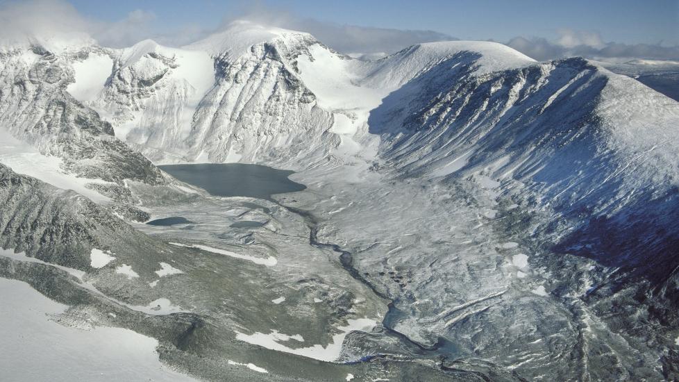
Archive photo of the area on a clear winter's day:
100 soldiers and 20 rescue workers ready for action.
Weather forecast looks better today (Link updated hourly):
Hourly forecast for Kebnekaise Sydtopp, Norrbotten (Sweden)
Archive photo of the area on a clear winter's day:
Last edited by roaldp; 17th Mar 2012 at 08:34.
Join Date: Jun 2009
Location: Norway
Age: 76
Posts: 43
Likes: 0
Received 0 Likes
on
0 Posts
Wreckage parts scattered over wide area
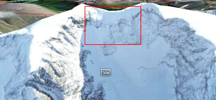
Swedish Air Rescue Central reports at 09:00 hrs that a ground-based rescue team has found "wreckage parts scattered over a wide area" on the west side of the North/South summit of Kebnekaise. The positions marked in this map should be seen as preliminary.
vg.no reports at 10:00 hrs that the discovery was made by Norwegian military ground crew at an elevation of 1500 metres.
Markings on map:
F�rmodat vrak 07:20 = Presumed wreckage
Oranga delar = Orange parts
Ev fynd markpersonal??? = Possible discovery ground crew???
Gr� vadd och kardborrerem = Grey padding and Velcro strap
Last edited by roaldp; 17th Mar 2012 at 09:05.
Join Date: Sep 2003
Location: 59�45'36N 10�27'59E
Posts: 1,032
Likes: 0
Received 0 Likes
on
0 Posts
Google translate of aftenposten.no
From VG:
Location indicated in this image
From VG:
We have found wreckage, and we have a crash site. There are thousands of pices of wreckage spread over a large area, said Haakon Bruun-Hanssen, head of the military's operational headquarters,

SkyGod
Join Date: Aug 2000
Location: Palm Coast, Florida, USA
Age: 67
Posts: 1,542
Likes: 0
Received 10 Likes
on
1 Post
It is also very well equipped with GPWS, TAWS,
A regular GPWS may not have been of much use approaching a vertical cliff face but an EGPWS with the terrain data base should have given plenty of warning.
How about Flight Recorder and Voice recorder, standard equipment in military planes..?
Join Date: Nov 2006
Location: Europe
Posts: 31
Likes: 0
Received 0 Likes
on
0 Posts
How about Flight Recorder and Voice recorder, standard equipment in military planes..?
Some journalist talked about the possibility of the Hercules doing tactical flying. I assume that is misinformed speculation, given the weather conditions at the time.
Champagne anyone...?
It's not an EGPWS as such however it does have a TAWS database which displays relevant proximate terrain graphically. The TAWS also has a Tactical Mode which operates at a higher resolution giving less nuisance alerts than the 1km blocks of the standard TAWS; I don't know if the Norwegians used this mode.
This is the TAWS display approaching terrain.
The GPWS in it's Tactical mode is effective and having flown the J myself for the last 10 years I've seen how it operates many times, both on Ops in Afghanistan and Iraq and in low level training in the UK, USA, ME and Norway. Sure, it won't stop you flying into a sheer, 90 degree vertical cliff but the accident terrain coupled with recorded radar returns suggest that wasn't the case here.
"Siv" was only delivered in July 2010. The J is a modern, well equipped and powerful aircraft (much more so than the 737 I'm now currently battling with). The C130J is FAA certified and has both data and flight recorders.
Join Date: Nov 2011
Location: Somewhere close to me
Posts: 742
Likes: 0
Received 0 Likes
on
0 Posts
Utdrag fra VG:
Radarm�linger viser at flyet befant seg mellom 2.194 meter og 2.316 meter over bakken. Kebnekaise er 2.111 meter p� det h�yeste punktet.
Er milit�r fly fritatt fra � holde MOCA, som her skulle minst v�rt 2000 ft over Kebnekaise?
Tragisk, bare undrer meg hvorfor de fl�y s� lavt!
Sorry just putting it English, from the newspaper VG (Online) they say the Radar shows that the aircraft was at approx. 2194 - 2316 meter altitude, while the mountain Kebnekaise is 2111 m at it's highest point.
I was just wondered if military aircraft do not have to stay at MOCA, which should have been 2000 ft above mountainous areas?
It is tragic, just wondering why they was flying at such a low altitude.
RIP
SkyGod
Join Date: Aug 2000
Location: Palm Coast, Florida, USA
Age: 67
Posts: 1,542
Likes: 0
Received 10 Likes
on
1 Post
Thanks for the replies Rick Studder and StopStart.
Looks like the aircraft had all the equipment then and sans an explosion, or 3 engine failures, there is no reason they should have been below the terrain.
I do most of my flying in South America in mountainous terrain and have had a few last minute pull-ups myself thanks to the EGPWS. It does wake you up...
Some newspaper reported the C-130 was in climb when it disapearred from radar.
Champagne anyone...?
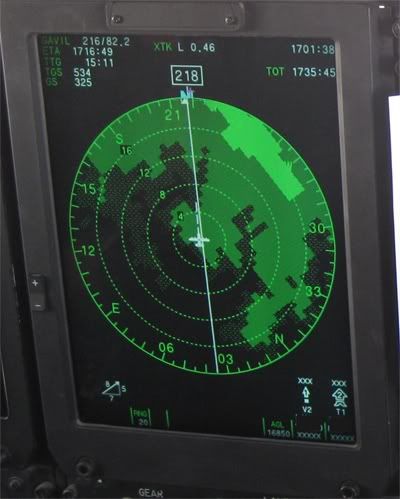
Using the radar returns and Google Earth I've plotted the salient points. The line assumes staying at 7600ft which obviously wasn't their intention. Even maintaining the assumed rate of climb from the returns they would have crossed the summit at 8100ft. One doesn't know that they weren't being affected by shear/turbulence etc at the time of radar returns....
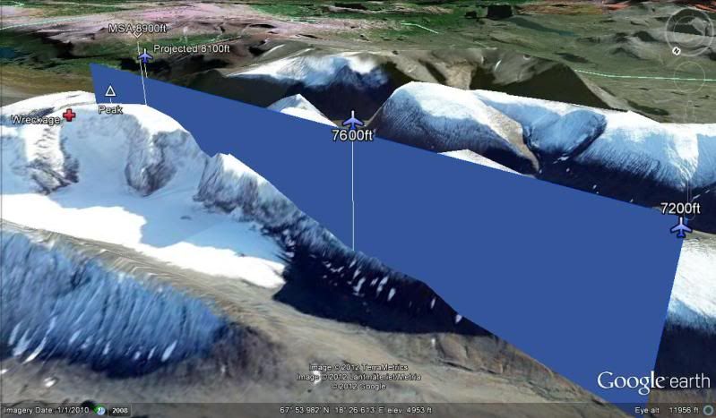
If this had been a VFR transit (low level or not) then they could well have seen reducing weather ahead and commenced a climb up to the their MSA/MOCA which would've been about 8900ft. The only thing I can assume at this stage is that they encountered a catastrophic weather event as they crested the ridge. Even the loss of an engine (on an empty aircraft like this) wouldn't have been a massive drama....
Remember, this was a military exercise. They may well have departed IFR but then once clear of the wx at ENEV, cancelled and gone VFR and possibly even descended into Low Level for the remainder of the transit. The TAF at destination gave no indication of anything untoward apart from the gusts increasing.
TAF ESNQ 151130Z 1512/1521 20015KT CAVOK
TAF ESNQ 151430Z 1515/1522 20015G25KT CAVOK
Similarly the TAF on departure didn't hint at anything unusual for Norway in March:
TAF ENEV 151100Z 1512/1521 21015KT 9999 -SHRA FEW008 BKN020 TEMPO 1512/1521 21025G35KT 4000 SHRA BKN012
Join Date: Sep 2003
Location: 59�45'36N 10�27'59E
Posts: 1,032
Likes: 0
Received 0 Likes
on
0 Posts
Google translate (a bit dodgy) of a interview with a Gripen pilot airborne in the area at the time of the accident.
Google translate from vg.no
Google translate from vg.no