


G Earth overlay for RAF airfields

Thread Starter
Join Date: Mar 2008
Location: Why oh why would I wanna be anywhere else?
Posts: 1,305
Likes: 0
Received 1 Like
on
1 Post
G Earth overlay for RAF airfields
Some time ago someone posted a link which enabled an overlay of all RAF establishments since year dot to be overlayed on G Earth. I had it on my old computer but not on my new one. Searches on PPRuNe have revealed nothing.
Can anyone remember it and/or point me in the right direction?
Can anyone remember it and/or point me in the right direction?

Join Date: Jun 2001
Location: Muscat, Oman
Posts: 604
Likes: 0
Received 0 Likes
on
0 Posts
Can't find it on PPRuNe, but the first post here might be what you're looking for.
RAF Stations in Great Britain - Google Earth Community
RAF Stations in Great Britain - Google Earth Community
Join Date: Apr 2010
Location: London
Posts: 7,072
Likes: 0
Received 0 Likes
on
0 Posts
Secret Bases • WWW.SECRET-BASES.CO.UK � 2011
has I think a Google earth file for ALL sorts of odds and sodds - old Thor bases, current MI6 intercept stations, POL depots in and out of use
has I think a Google earth file for ALL sorts of odds and sodds - old Thor bases, current MI6 intercept stations, POL depots in and out of use
I don't own this space under my name. I should have leased it while I still could
Interesting to see RAF Humberston. You can make out a set of foundations in a field; it looks like a hutted camp.
Don't take the positions as gospel however. RAF Wainfleet is misplotted. The plot shows the 1990s site after it moved from Wainfleet to Friskney. RAF Holbeach is some 3 miles out too.
Don't take the positions as gospel however. RAF Wainfleet is misplotted. The plot shows the 1990s site after it moved from Wainfleet to Friskney. RAF Holbeach is some 3 miles out too.
Join Date: Mar 2007
Location: gla
Posts: 33
Likes: 0
Received 0 Likes
on
0 Posts
How long did it take
Slightly off topic, but looking at any map of the UK it seems that one is never very far from a WWII airfield. They seem to have been stamped onto the landscape with a giant rubber stamp almost willy nilly.
How long did it take from start to finish to build all these airfields? It seems like a Herculean effort given the length of the war.
How long did it take from start to finish to build all these airfields? It seems like a Herculean effort given the length of the war.
Thread Starter
Join Date: Mar 2008
Location: Why oh why would I wanna be anywhere else?
Posts: 1,305
Likes: 0
Received 1 Like
on
1 Post
Not quite sure of build time but one interesting fact emerges. For hardcore for the runways etc they used the rubble from bomb damage in the cities. Subsequently when the airfields were gradually torn up after the war the hard core and smashed concrete was used for hardcore for the motorway programme.
Waste not, want not. Thanks Adolf.
Waste not, want not. Thanks Adolf.
Champagne anyone...?

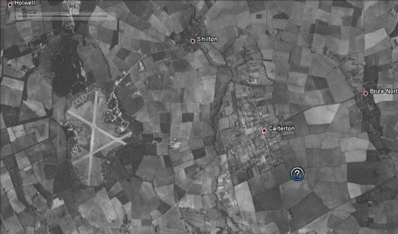
Ok this is possibly a Storm force 10 bordering on violent storm 11 piece of geekery however whilst perusing the Google Earth 1940s aerial photos layer I noticed that RAF Brize Norton wasn't anywhere to be found. If the internet is to be believed (and lets be fair here, it's never been wrong before) Brize was built in 1937. The aerial pic shows the neighbouring RAF Broadwell (43-47) but no Brize. I can't see an obvious join in the imagery so I can only assume it must've been taken up in an early Rapture. Any other slightly more far fetched ideas as to where Brize is/was....?
Thread Starter
Join Date: Mar 2008
Location: Why oh why would I wanna be anywhere else?
Posts: 1,305
Likes: 0
Received 1 Like
on
1 Post
A triumph of photographic deception! I suspect that the censors have drawn fields etc over the airfield in order to confuse the wily Hun and just forgot to take the overlay off.
I don't own this space under my name. I should have leased it while I still could
According to my source, which predates the internet, Brize certainly opened in 1937. It had permanent accommodation and two 2000 yard runways of concrete and woodchip by 1944. It belonged to 23 Gp and was a heavy glider conversion unit.
Clearly the photo, taken in 1945, was after the site was 'cleared' as part of the chemtrail introduction and the laying of the chem pipes around the base for the US. Cleared, as Siseman says, meant artful camouflage to deter Russian satellites that might have been built in secret during the war.
PS
In case anyone thinks it is a much earlier photograph, RAF Broadwell was not opened until 1943.
Champagne anyone...?
Hmmm indeed. Further perusal of the area reveals yet more disappearances. In fact, having erased almost everywhere I think they just got bored by the time they got to Broadwell. Should you have trouble sleeping then close inspection of sites like Moreton In Marsh, Little Riz and Enstone does reveal some rubbing out of runways and artful drawing in of trees and hedges.
I need to get out more
I need to get out more
Maybe it's because it was deemed OK to show disused aerodromes such as Broadwell and Akeman Street (near Leafield), but not active ones?
Maps of the period often just include the word 'airfield' and that's about all. One step up from 'Here be dragons', I guess?
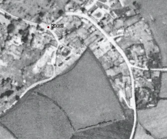
I wonder whether the PIs had a suitable bunch of anonymous countryside photos which they just snipped into shape and stuck over the actual imagery? The aerial map of Keevil looks rather odd, for example.
Maps of the period often just include the word 'airfield' and that's about all. One step up from 'Here be dragons', I guess?
I wonder whether the PIs had a suitable bunch of anonymous countryside photos which they just snipped into shape and stuck over the actual imagery? The aerial map of Keevil looks rather odd, for example.
Champagne anyone...?
That sounds sensible - there does seem to have been some early cut and paste going on around Keevil....
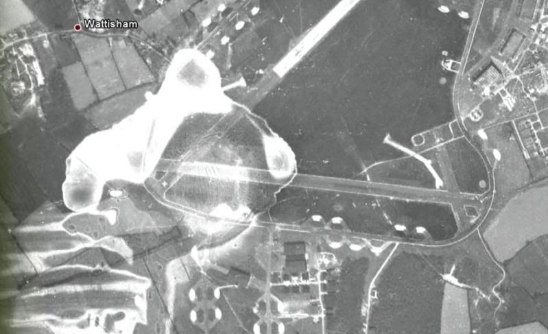
Interestingly (quotes may be added around that word as required) there doesn't seem to have been the same strict censorship applied to the aerial pics taken on the other side of the country. Someone did spill coffee on Wattisham though....
Interestingly (quotes may be added around that word as required) there doesn't seem to have been the same strict censorship applied to the aerial pics taken on the other side of the country. Someone did spill coffee on Wattisham though....
I don't own this space under my name. I should have leased it while I still could
Maybe it's because it was deemed OK to show disused aerodromes such as Broadwell and Akeman Street (near Leafield), but not active ones?
Maps of the period often just include the word 'airfield' and that's about all. One step up from 'Here be dragons', I guess?
I wonder whether the PIs had a suitable bunch of anonymous countryside photos which they just snipped into shape and stuck over the actual imagery? The aerial map of Keevil looks rather odd, for example.
Then in later 60s we got new ordnance survey maps and the complete airfield details, including SSAs, was printed. We thought at the time that OS had got on to the airfields when they went in to C&M for upgrades.
As the mapping updates was ongoing we still needed SD892. An amendment came out that removed many wartime airfields and would have reduced its value to us if incorporated. Against all the rules we simply filed the amendment and retained the out of date copy.
PIs had a suitable bunch of anonymous countryside photos which they just snipped into shape and stuck over the actual imagery
Later JARIC also produced fix point overlays for the TSR2 SLAR. These were masterpieces of modelling. Fabrics, pipe cleaners etc were manipulated and then oblique photographs taken to give as accurate an impression of a SLAR fix-point image. If you think about it, this was the ultimate inflexible navigation aid.
Public access to wartime mapping was restricted by the Directorate of Military Survey in the early 1970s after concern was expressed at the likelihood of illegal immigrants being flown in 'under the radar' from the continent. Indeed, in November 1971 a quick-witted farmer rammed a Cherokee at Kimbolton aerodrome which had been flown in by a Syrian pilot - it contained 4 Indian and 1 Pakistani passengers. The Syrian had tried to bribe the farmer after trying to run off, but the farmer went for him with a spanner....
If you see an aeronautical map of the early 1950s, it looks as though someone has fired a shotgun at the map of East Anglia - there were well over 100 aerodromes! When I flew my PPL qualifying cross-country back from Ipswich to Cranfield, there were about a dozen aerodromes within 3 miles of my track on one side or another - and I was advised not to use them as fixes due to the ease of mis-identification.
If you see an aeronautical map of the early 1950s, it looks as though someone has fired a shotgun at the map of East Anglia - there were well over 100 aerodromes! When I flew my PPL qualifying cross-country back from Ipswich to Cranfield, there were about a dozen aerodromes within 3 miles of my track on one side or another - and I was advised not to use them as fixes due to the ease of mis-identification.
Join Date: Apr 2010
Location: Sneaking up on the Runway and leaping out to grab it unawares
Age: 61
Posts: 684
Likes: 0
Received 0 Likes
on
0 Posts
Later JARIC also produced fix point overlays for the TSR2 SLAR. These were masterpieces of modelling. Fabrics, pipe cleaners etc were manipulated and then oblique photographs taken to give as accurate an impression of a SLAR fix-point image. If you think about it, this was the ultimate inflexible navigation aid.
A bit like the old Ecko 190 Radar predictions for the Dominie then.

I don't own this space under my name. I should have leased it while I still could
At 24,000 the pilot of the meatbox in a high bank turn said where is Stradishall Nav? It was a safe bet when I said down there (100%) 10 o'clock which was a fair guess (80%) but a racing certainty given odds of 1:5.
PS, Found provenance of the 1945 photos. One has Ordnance Survey and added names and positioning data and nearby the imagery date is 1/1/45.
Last edited by Pontius Navigator; 23rd May 2011 at 12:36.
RAF Wyton
The 1945 image of Wyton throws up a few anomalies, if the main runway was extended in the 50's for the 'V' bombers, why is it the same length as 1945, and also what looks like 4 Canberra's are parked on the disused runway to the left of the (1945) V bomber dispersal where the Canberra OCU operated from.


Thread Starter
Join Date: Mar 2008
Location: Why oh why would I wanna be anywhere else?
Posts: 1,305
Likes: 0
Received 1 Like
on
1 Post
While the G Earth says it's from 1945 it's actually a much later photo. The hardstandings and runway extension (although ORP not yet built) are the standard V Force pattern and the aircraft are Canberras. Suspect it was in the period when the base was being upgraded for Victors.