


Chinook - Still Hitting Back 3 (Merged)

Indie' Review
Have the Terms of Reference for Lord Philip's review been published yet? My computer/telephone have been down for several days and so am behind the curve (as usual)!
O-D
O-D

Duffer
I'm sure LP has them, but they haven't been published to my knowledge. I imagine one pressing issue is the status of evidence MoD has consistently witheld from various inquiries. Nevertheless, what has been obtained has been presented him. (And still MoD denies its existence!).
I'm sure LP has them, but they haven't been published to my knowledge. I imagine one pressing issue is the status of evidence MoD has consistently witheld from various inquiries. Nevertheless, what has been obtained has been presented him. (And still MoD denies its existence!).
Join Date: Sep 2003
Location: Perth, Western Australia
Posts: 786
Likes: 0
Received 0 Likes
on
0 Posts
flipster
So you can get a feel for just how difficult it is to get answers from the RAF/MOD I address just one of your points as an example:
<<Has anyone checked the remainder of the wreckage, I believe, still in a hangar at Lee-on-Solent for suspicious gaps of the correct dimensions in the cockpit panels? >>
When I was over there (visit before last?) I made great efforts to get access, get someone independent access, or get just someone within the MOD to specifically check this; the response I had from the officer in charge of the facility was something like even his own men couldn't access it any more as there was a problem with toxic contaminants and in any case it was going to be moved somewhere else shortly.

Join Date: Sep 2003
Location: Perth, Western Australia
Posts: 786
Likes: 0
Received 0 Likes
on
0 Posts
chinook240
I believe I have posted a piccie of an HC2 cockpit before - here it is with annotation showing where the remote display unit sits (RDU):
http://i229.photobucket.com/albums/e...HC2withRDU.jpg
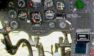
The more revealing area would have been where the ARS6 unit sat - it is big and there would have been mountings and connectors for it (there was a one off mention of a wiring irregularity referred to once but no one could substantiate this).
I only gave this example just now to show the type of (un)cooperative response one gets with this case.
I believe I have posted a piccie of an HC2 cockpit before - here it is with annotation showing where the remote display unit sits (RDU):
http://i229.photobucket.com/albums/e...HC2withRDU.jpg
The more revealing area would have been where the ARS6 unit sat - it is big and there would have been mountings and connectors for it (there was a one off mention of a wiring irregularity referred to once but no one could substantiate this).
I only gave this example just now to show the type of (un)cooperative response one gets with this case.
Last edited by walter kennedy; 9th Oct 2010 at 11:00. Reason: picture
Join Date: Sep 2003
Location: Perth, Western Australia
Posts: 786
Likes: 0
Received 0 Likes
on
0 Posts
Oh and the absence of the RDU isn't conclusive - a quick fit (30 minutes) would not involve the RDU - the CDU can be left plonked on/near the ARS6 module and the readings relayed to the pilots by a loadmaster (which may explain why he was not at the window seat doing his "sideways" navigation).
For a feel of the size of the ARS6, compare the following piccie of the complete equipment with the above cockpit (recognising the RDU):

For a feel of the size of the ARS6, compare the following piccie of the complete equipment with the above cockpit (recognising the RDU):
Join Date: Jul 2002
Location: UK Sometimes
Posts: 1,062
Likes: 0
Received 0 Likes
on
0 Posts
Walt,
Well done for trying - you are nothing if not persistent!
Where is the wreckage being moved to and when?
Where would the CDU sit and what exactly does the RDU display?
flipster
Well done for trying - you are nothing if not persistent!
Where is the wreckage being moved to and when?
Where would the CDU sit and what exactly does the RDU display?
flipster
Join Date: Jan 2010
Location: High Wycombe UK
Posts: 52
Likes: 0
Received 0 Likes
on
0 Posts
More on Maps........
I have always had a gut feeling that navigation accuracy played a big part in the crash , whatever other problems there were with the Chinook..........
The waypoint 'A' position has always bothered me.......... and having turned my attention to waypoint 'B' , I have noticed disturbing things here too...............
At first the waypoint 'B' looks like a fairly good choice as it is at a place where the Loch narrows down , and it is actually on waste ground next to a main road at Inchcree...........(ie... possible emergency landing site.)....
.....but there is a larger open space across the water beyond the Corran lighthouse itself ......and ......more significantly..... they could not really overfly this chosen waypoint at low level because it would bring them dangerously close to the 206 metre (675feet) high hill 'Druim na Birlinn'.......just past it on the right-hand-side of the Loch. ..
.....so again it seems unlikely that the waypoint chosen on the map by the crew was actually the point identified by the latitude and longitude co-ordinates found in the Supertans...
If you wanted a waypoint at a place where a canyon narrows , in effect that is what happens at Corran , you would surely place it in the middle somewhere , close the the Corran lighthouse for example..............but in the case of waypoint 'B' , it is off to one side..as though it has been displaced........in fact in the same direction as waypoint 'A' appears to be offset to me......
In this case , I think once is an anomaly , twice is a pattern ......and that the same procedure was used to derive the co-ordinates for waypoints 'A' and 'B' .........
Lots of people have questioned the waypoints 'A' and 'B' ..............more so than the other waypoints , as they are not defined to the same accuracy , or number of decimal places as points 'C' and 'D'. If the crew had the choice of a more accurately defined waypoint , I cannot imagine that they would truncate it , as they would know that the actual waypoint would move.........
...points 'A' and 'B' must always have been defined to the accuracy of the digits found in the Supertans...............which strongly suggests to me that they were derived from a map ............an OS map on the scale 1:50,000 is marked on the map edges in minutes of both latitude and longitude.........
.....so further to my # 6597 on page 330 .............I think the co-ordinates for both waypoints 'A' and 'B' were derived by wrongly reading an OS map ........and they thought they were flying towards a waypoint 'A' which was at least 300 metres out to sea.............
......if my explanation is hard to follow there is a link here to a detailed guide with photos.....
Robin Clark.....
Per Ardua ad Astraeus
Join Date: Mar 2000
Location: UK
Posts: 18,579
Likes: 0
Received 0 Likes
on
0 Posts
Robin - I would caution against too much 'attention' to nav co-ords. I have never conducted low-level heli ops as anything other than a 'joy-rider' but have fair experience of fixed wing LL ops. Such a nav system would NOT be used to the accuracy you are suggesting - the ops are visual, relying on visual features to navigate and any such nav system would be loaded only as back up, I'm sure. One might well use it to get into the general area of a waypoint but nothing else - in those days it would have been nowhere near accurate enough.
Join Date: Sep 2005
Location: preston
Age: 76
Posts: 376
Likes: 0
Received 0 Likes
on
0 Posts
Robin,
Waypoints were rarely taken from OS charts. They were nearly always taken from the half mil LFC. If you achieved 0.5nm you were doing quite well.
Now LZ, DZ, TGT, OFFSET, they were different. But a Waypoint / Turning point? I don't see anything sinister or flawed with this degree of accuracy.
Remember, you did not have to overfly your Waypoint. It was just something to attract your attention.
Join Date: Sep 2003
Location: Perth, Western Australia
Posts: 786
Likes: 0
Received 0 Likes
on
0 Posts
flipster
Surely you would be better positioned than me to follow this up � try persuading those that have used the kit to give us all an explanation � then you will understand, perhaps, just how afraid they are of talking about it.
Robin Clark
Perhaps you should search through this thread before reopening issues � unless of course it is your job to help keep the debate going around in circles:
I have addressed the coordinate issue a long time ago � some were just convenient intersections (or, say � squares) � the STANS can accept either input (lat/lon or grid) but will keep all those unecessary digits if you change display units.
I believe waypoint A was the only accurate one, possibly remembered coords from previous visits � perhaps you could try and understand by looking at the list of waypoints below:
H N54.47.70 W006.36.00 a field, no specific feature, about 1 km east of a village called Curran, exactly at H 900 950 on Irish grid;
A N55.18.50 W005.48.00 within tens of metres of a known LZ used by large military helicopters, not at intersection of any cardinal grid lines nor a simple fraction thereof;
B N56.43.00 W005.14.00 again a field, no specific feature, about 1 km east of a village called Corran;
C N57.35.02 W004.04.45 100 metre swim to Ft George, exact intersection of two grid lines on an OS map � GB grid NH 760 570;
D N57.32.42 W004.02.92 about middle of Inverness aerodrome, on grid line 52 and half way between 77 & 78, thus NH 775 520
Last edited by walter kennedy; 12th Oct 2010 at 05:06. Reason: cut out
Join Date: Jul 2002
Location: UK Sometimes
Posts: 1,062
Likes: 0
Received 0 Likes
on
0 Posts
Walt,
No-one is afraid of talking about it - just put 'PRC112' or 'ARS6' into Google and see how much is open-source. Eg.
AN/ARS-6(V) Personnel Locator System (PLS) (United States) - Jane�s Military Communications
The RDU is a very basic display that gives very raw left or right of nose indications and appox DME. Also, it is in front of the LH Seat NHP/PNF and so is definitely not something many people, as HP/PF, would want to blindly follow in IMC towards culmulo-granite at high speed, if your theory is correct.
OTOH, what is known is that UK Chinooks had CPLS fitted around the time of the crash as a STF - BUT there is no record of STF or SD paperwork, even in a secret sub-section of the RTS. Records should be kept, even if the capability was sensitive (which it probably was then, as the system used crypto-variables). Ultimately, this further shows how immature was was the design process and EMC trials of the HC2. To my mind, this creates even more doubt!
flipster
Thank you Walt for helping us find the information.
Join Date: Sep 2003
Location: Perth, Western Australia
Posts: 786
Likes: 0
Received 0 Likes
on
0 Posts
flipster
<<No-one is afraid of talking about it - just put 'PRC112' or 'ARS6' into Google and see how much is open-source. >>
Now that's just plain disingenuous � its practical use by the RAF is a taboo subject, so far at least � your own discrediting of its usefulness is contrary to what even the manufacturers' limited blurbs claim.
<<The RDU is a very basic display that gives very raw left or right of nose indications and appox DME. >>
The left/right resolution is +/- 4 degrees which, as the range shortens, is well accurate enough to close to a fixed point where the hand set (PRC112) is located on the ground. The distance is very accurate, just remember that it is slant range when you get close but that doesn't matter if you are going right there knowing its elevation.
One of its stated uses is all-weather approaches to drop zones/LZs/extraction points etc. There would have been nothing wrong with approaching the LZ at way point A (the �green triangle� as locals who have seen helos land there refer to it) referring to a PRC112 that was actually on that LZ � there was a safe wave-off swinging around the back of the light house and back out to sea (plenty of room at even their highest speed) � but if they had been using it, remembering that they had already dumped their STANS local reference point (A), they would only have had their visual judgement to warn them if the set on the ground was out of position � and this is where the weather affected them:
the weather of interest was generated by the landmass and was fixed on the landmass;
the higher topographic features were shrouded in the orographic cloud and the slopes had that intermittent veil of mist running up them (strong wind causing �speed-up� effect as I have described previously) blurring ground detail making visual judgement of range impossible � it was not that they were in IMC (during the critical phase of their approach) but that the landmass that they could see (for a considerable distance) was almost as difficult to judge for distance off as would be a cloud.
Had the equipment been on the LZ at way point A, the loadmaster could have been ready to eyeball the moment that they crossed the shoreline by looking out of the side window (his usual position during any approach to, say, an LZ) � had it been further up the slope, it could have caught them out, their oblique approach taking them on a path to higher ground with no wave-off and no doubt confusing them, the loadmaster not even in his position from where they are renowned for �sideways� navigation and from where he would have been best placed to call the moment that they had crossed the shoreline � a delay of just a few seconds would have been enough to have caused this crash.
Remember also that the a/c had started to slow down (in terms of TAS) as was consistent with the matched power levels found such that they were probably �coasting in� (for a close pass of the LZ and the following swing around the back of the light house) and so they were in a worst case scenario for demanding a sudden increase in power � one of the options they would have had was a sideways slew (as I have explained previously) that causes rapid slowing and immediate increased lift which it would appear that the HP had initiated in the last seconds.
In short, the most obvious scenario is that they were to swing around the light house using a PRC112 as a reference on a known LZ (way point A) but that reference was out of position.
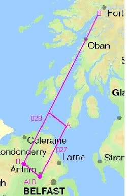
An exercise like this would not have affected their schedule at all as, if you recall the schematic of their planned routes that I posted some time ago:
had the weather precluded crossing the Antrim hills or approaching the MULL under VFR at all, there was a safe route already planned by Lt K (RN) which was Aldergrove to Curran (wpt H) across the top of Lough Neagh, thence to Corran (wpt B) � clear level low ground all the way;
this path was exactly the same (in terms of distance and timing) as Aldergrove to Mull (wpt A) thence NW to pick up the H-B track so all schedule and fuel calculations were the same � one of the pilots had 028 (the mag bearing from H to B) set on his HoSI course selector ready, it seems, to head for that track after their business at the Mull.
So any such training exercise would not have had any detrimental affect on the �ferry� flight had it not gone wrong � and this is in line with the RAF's stated policy of fitting in training on just about any flight where possible for obvious reasons of economy.
<<No-one is afraid of talking about it - just put 'PRC112' or 'ARS6' into Google and see how much is open-source. >>
Now that's just plain disingenuous � its practical use by the RAF is a taboo subject, so far at least � your own discrediting of its usefulness is contrary to what even the manufacturers' limited blurbs claim.
<<The RDU is a very basic display that gives very raw left or right of nose indications and appox DME. >>
The left/right resolution is +/- 4 degrees which, as the range shortens, is well accurate enough to close to a fixed point where the hand set (PRC112) is located on the ground. The distance is very accurate, just remember that it is slant range when you get close but that doesn't matter if you are going right there knowing its elevation.
One of its stated uses is all-weather approaches to drop zones/LZs/extraction points etc. There would have been nothing wrong with approaching the LZ at way point A (the �green triangle� as locals who have seen helos land there refer to it) referring to a PRC112 that was actually on that LZ � there was a safe wave-off swinging around the back of the light house and back out to sea (plenty of room at even their highest speed) � but if they had been using it, remembering that they had already dumped their STANS local reference point (A), they would only have had their visual judgement to warn them if the set on the ground was out of position � and this is where the weather affected them:
the weather of interest was generated by the landmass and was fixed on the landmass;
the higher topographic features were shrouded in the orographic cloud and the slopes had that intermittent veil of mist running up them (strong wind causing �speed-up� effect as I have described previously) blurring ground detail making visual judgement of range impossible � it was not that they were in IMC (during the critical phase of their approach) but that the landmass that they could see (for a considerable distance) was almost as difficult to judge for distance off as would be a cloud.
Had the equipment been on the LZ at way point A, the loadmaster could have been ready to eyeball the moment that they crossed the shoreline by looking out of the side window (his usual position during any approach to, say, an LZ) � had it been further up the slope, it could have caught them out, their oblique approach taking them on a path to higher ground with no wave-off and no doubt confusing them, the loadmaster not even in his position from where they are renowned for �sideways� navigation and from where he would have been best placed to call the moment that they had crossed the shoreline � a delay of just a few seconds would have been enough to have caused this crash.
Remember also that the a/c had started to slow down (in terms of TAS) as was consistent with the matched power levels found such that they were probably �coasting in� (for a close pass of the LZ and the following swing around the back of the light house) and so they were in a worst case scenario for demanding a sudden increase in power � one of the options they would have had was a sideways slew (as I have explained previously) that causes rapid slowing and immediate increased lift which it would appear that the HP had initiated in the last seconds.
In short, the most obvious scenario is that they were to swing around the light house using a PRC112 as a reference on a known LZ (way point A) but that reference was out of position.
An exercise like this would not have affected their schedule at all as, if you recall the schematic of their planned routes that I posted some time ago:
had the weather precluded crossing the Antrim hills or approaching the MULL under VFR at all, there was a safe route already planned by Lt K (RN) which was Aldergrove to Curran (wpt H) across the top of Lough Neagh, thence to Corran (wpt B) � clear level low ground all the way;
this path was exactly the same (in terms of distance and timing) as Aldergrove to Mull (wpt A) thence NW to pick up the H-B track so all schedule and fuel calculations were the same � one of the pilots had 028 (the mag bearing from H to B) set on his HoSI course selector ready, it seems, to head for that track after their business at the Mull.
So any such training exercise would not have had any detrimental affect on the �ferry� flight had it not gone wrong � and this is in line with the RAF's stated policy of fitting in training on just about any flight where possible for obvious reasons of economy.
Walter
Your alternate track is fascinating and, like the CPLS theory, certainly feasible. However, the RUC interviewed 8 witness who placed a Chinook on your Aldergrove > Waypoint A track at the correct times; from locations in Antrim, Moorfields and Carnlough/Glenarm.
Of the other 4 witnesses, one merely reported "a helicopter" up in Dervock (roughly on your Waypoint H > B track). Another saw a Chinook over Ballymena, but this was more than 2 hours earlier.
The only real discrepancy comes with the final two witness, one ex-Army and familiar with Chinooks, who (separately) saw one heading from Ballymena to Carnlough (roughly NE) at 1730. My memory of the topography is very vague indeed, but I'd say it is possible they are describing an event whereby the aircraft took a westerly detour at low level around Slemish Mt to rejoin the main track further up the Carnlough Road.
On balance, and lacking data recorders (!) I'd say it is a fair assumption they were on the direct Aldergrove > Mull track, with perhaps a slight detour around hills.
Sorry for any terminolgy slips. I look at these things strictly from sea level.
Per Ardua ad Astraeus
Join Date: Mar 2000
Location: UK
Posts: 18,579
Likes: 0
Received 0 Likes
on
0 Posts
On a quick read, tuc, I think you have mis-interpreted Walter's post?
Walter - I can see no logical reason for anyone to 'hide' the fitment of what is/was a pretty standard concept in a helicopter. Radio homing devices have been around and used for decades. Whether this kit to which you refer was 'secret' or 'on special trial' I do not know. Likewise no logical reason to 'hide' the fact that it might have been fitted on this hull.
What you are suggesting is that the 'hiding' here would have been
a) The brief to 'test' it on this trip
b) The involvement of 'nefarious' personnel (your 'men in black') in this 'test'
Why not focus on that? What 'evidence' can you muster that the crew (who wanted a MK I?) were either tasked or briefed on such a 'test'. That would indeed be crucial to your case.
For all of the maps, photos, radios fitted or unfitted, Walter's theory is just that, theory. Not only theory but theory based upon conjecture, and that in turn based upon the fierce conviction that to lose all those key personnel in one foul swoop at such a crucial period of NI history could only mean one thing, conspiracy! From someone so supposedly versed in the ethos of aviation, that you first look at all the known facts before trying to make them make sense, I find his process illogical.
We now know that whatever befell ZD576 0n that fateful day it was, in company with its sister HC2's, Grossly Unairworthy. That was known then as well, though perhaps not in so many words, for as we have discovered within this forum the "A" word is seen by many as "Not me Chief, I'm aircrew!". Hopefully one of the positive spin-offs from this tragedy will be a better understanding of how vital airworthiness is to the Role of Military Aviation. Needless, pointless waste like Mull not only is a human tragedy in itself but a direct attack on the RAF's ability to do its job, ie to wage war.
So a grossly unairworthy aircraft crashes with great loss of life, and Walter lays the blame on a man in black being in the wrong place at the wrong time (Or the right place? I'm still confused about that!). I'm afraid that Mr Spock would be driven to one of his tiresome homilies that always began, "Not logical, Captain....!".
Join Date: Jun 2007
Location: 119K East of SARDOT
Posts: 146
Likes: 0
Received 0 Likes
on
0 Posts
BOAC,
Walter knows I don't support his theories, but why don't you divert some of your energy towards getting a response from nigegilb, who made the following 2 statements sometime ago, and, who recently, still did not choose to retract them?
'MoD has consistently stated that ARS-6 was not fitted. I believe this to be total deceit and I also believe this thread is an appropriate place to highlight that deceit.'
'I have also been shown evidence which indicates that ZD576 was carrying STF equipment on that fateful day and I think it important to establish that breaches of airworthiness regs continued from that day to this day specifically regarding Special Trials Fit procedures.'
This is about the supression of relevant information per se, and how the MOD has yet to be held to account in an 'open forum' re this accident.
S4G
Per Ardua ad Astraeus
Join Date: Mar 2000
Location: UK
Posts: 18,579
Likes: 0
Received 0 Likes
on
0 Posts
Sand - the apparent dire state of the competence of the 'seniors' at the time and the apparent lack of airworthiness of the Mk II is indeed very important, but it should not be forgotten that the Nimrod also joins that sorry party, as probably do several other at present unknown service types.
The scope of this is really is vastly outwith the campaign here. Agreed, of course, that it helps the case somewhat, but even if it was 'fitted' or 'carried' it needs to be shown that the assassination attempt took place for it to have a real bearing on this crash. I doubt that and I see no evidence to support that.
The scope of this is really is vastly outwith the campaign here. Agreed, of course, that it helps the case somewhat, but even if it was 'fitted' or 'carried' it needs to be shown that the assassination attempt took place for it to have a real bearing on this crash. I doubt that and I see no evidence to support that.
BOAC
I think the issue of whether or not CPLS was fitted is very important, but not for Walter's reasons.
If it was fitted there is no evidence of testing, trials, an installed performance being established, EMC (for example) issue with other kit - all of which is a pre-requisite to CAR/RTS. (The Service Deviation for CPLS was issued in 1995, but that certainly doesn't preclude ZD576 being an early trials vehicle).
As I also stated a long time ago, a BoI witness confirmed "classified" kit was fitted, but similarly this is not mentioned in the CAR/RTS; despite the regulations. I merely ask if this classified kit and CPLS were one and the same. The BoI did not pursue this, even though the possibility of an EMC problem was obvious.
(I think that goes a long way toward answering Sand4Gold's request of nigegilb, who I know is referring to the fact CPLS and the precise location it was fitted have been known about for some time; certainly long before the SD emerged - which confirmed an EMC problem when using the kit. It was the repeated denials of the existence of the kit on this thread that prompted questions which revealed the relevant SDs).
Hence, failure of airworthiness process is, in my opinion, a key area. It is evidence of Organisational Fault, which the BoI were duty bound to investigate, but didn't.
Regarding my last post, Walter has posted that diagram before, his theory being the flight was intended to include all or part of the H > B leg. Therefore I think my post relevant.

