


Chinook - Still Hitting Back 3 (Merged)

Join Date: Sep 2005
Location: preston
Age: 76
Posts: 376
Likes: 0
Received 0 Likes
on
0 Posts
Waypoints, Fixpoints and Turning Points
When entering Waypoints into a piece of accurate GPS equipment there are two kinds of Waypoints entered.
First are turning points. These are nearly always taken from a LFC, measured with a protractor and entered with an accuracy of about 0.5nm.
The slight errors entered are not critical, because they are simply tools to help find your way around a route in VMC. You often have no intention of overflying these points just acquiring and then turning.
Second are precision entries of points that it is critical for you to make.
These can include DZ's, LZ's, Targets, Runway Threshholds, Final approach fixes anything that is critical that you have to approach precisely.
You can get the accurate positions from a variety of sources including TAP,s, DZ and LZ handbooks. For a one off you might send a man with a GPS, ahead of your mission.
As a last resort you will again plot out from a chart, but this time you will use an Ordnance Survey and be looking for errors of a few metres.
Waypoint A N5518.50 W00548.00 looks like a turning point, the numbers are too regular. It is close enough to the lighthouse to allow that to be the planned TP.
Even if those co- ordinates are the precise location for an LZ, there is another problem with theory. In most conditions, especially poor weather, the crew would have pre planned their approach and you would see another Waypoint between Belfast and the Mull

Join Date: Apr 2005
Location: France 46
Age: 77
Posts: 1,743
Likes: 0
Received 0 Likes
on
0 Posts
Chinook ZD 576
BOAC
Your interpretation of his Lordships position is, in my opinion, incorrect.
Try House of Lords debates: House of Commons and House of Lords (TheyWorkForYou.com) - House of Lords debates - Tuesday 5 November 2002. Chinook Select Committee Report.
Regarding the findings of the AOC and AOC in C His Lordship stated:
"To my mind, it is not only perfectly justifiable, but it is only proper, that such a serious breach of the rules for visual flight shoud be regarded as negligent, and, under the terms of such a report being produced at that time, considered to be grossly negligent. If those rules had not been breached, there is no doubt that the accident would not have happened."
I totally agree with those sentiments.
Last edited by cazatou; 16th Jun 2009 at 14:03.
Join Date: Apr 2005
Location: France 46
Age: 77
Posts: 1,743
Likes: 0
Received 0 Likes
on
0 Posts
Tandemrotor
"IMHO there is not a chance that this accident was caused by any kind of approach to any landing site"
Was not the "misplotted position of the lighthouse" in fact an HLS?
Has anybody ever asked the person who prepared the chart what the planned turning point was?
"IMHO there is not a chance that this accident was caused by any kind of approach to any landing site"
Was not the "misplotted position of the lighthouse" in fact an HLS?
Has anybody ever asked the person who prepared the chart what the planned turning point was?
Per Ardua ad Astraeus
Join Date: Mar 2000
Location: UK
Posts: 18,579
Likes: 0
Received 0 Likes
on
0 Posts
In the interests of posting the noble Lords' sayings, and not just being TOO selective, I feel the next speaker says it all.
"There is no doubt in my mind that some of your Lordships who are confident of the propriety of the verdict of gross negligence have recounted the story of what happened as a narrative, telling us what the pilots did and where they went wrong and asserting that they were rash, that they did not take the weather into account and that they were flying too fast and too low. Like many narratives, it is delivered with great conviction. The people who have told it have frequently said that it is the only realistic or credible explanation. That is the power of the good story teller, who proceeds on the assumption that they know how it must have been and then we all believe it. As regards the standard of proof and there being no doubt whatsoever of the propriety of the verdict, one must begin to doubt�as, indeed, people, including the unanimous body of the Select Committee, did doubt�that that standard had been reached. One may argue that it is an impossibly high standard and that there can be no past events for which it is proper to say that there can be no doubt whatsoever as regards what happened. Nevertheless, those are the relevant words."
I try to apply logic as much as possible, and I would be interested to hear your explanation of the Waypoint change made by the crew before the Mull. Why would they do it, and why do you think they selected a track which would take them over high ground when you obviously believe "the aircraft WAS in cloud and NOT ? flying VFR (when they made the waypoint change)" That is just NOT logical.The only LOGICAL explanation is that they had the Mull in sight and sequenced the waypoint. Exactly as the CO said "This WP change is crucial in trying to understand what the crew intended to do."
So, once again, we come back to the crucial point. The waypoint change. So far, JP has been unable to build any certainty into what the view from the cockpit was at that point.
So caz, do you believe that ZD 576 was in cloud at waypoint change? If so, is it because:
a) you have evidence to prove it beyond any doubt?
b) their Airships thought so and that's good enough for you?
c) you enjoy winding everybody up?
d) other.
Incidentally, the inclusion of "it seems to me" and "methinks" does have the same meaning as "in my opinion" (4812,4814). You do seem to have a blind spot here. Perhaps tandemrotor's dictionary explanation has helped you.
Last edited by pulse1; 16th Jun 2009 at 15:40.
Join Date: Aug 2006
Location: BATH
Posts: 375
Likes: 0
Received 0 Likes
on
0 Posts
Chinook
Pulse1. I do not understand your confusion. There are, as been said here many times before, only two possibilities:
(a) the crew could clearly see the hills ahead of them, and prudent airmanship as well as a basic sense of self-preservation would have told them to turm away before they reached them.
(b) the crew could not see the hills ahead of them (cloud/mist/fog /bird strike/ oil on the windscreen- take your choice) in which case prudent airmanship as well as self preservation would also have told them to turn away. Please take your choice.
By the way, if you now tell us that the controls were locked solid (in all dimensions) and the power controls were also inoperatve, and that the crew thus sat there utterly helpless as they were flown into the hills by their aircraft, then we are back to where we were in this discussion about two years ago. Do come off it!!
Regards,, JP
Last edited by John Purdey; 16th Jun 2009 at 16:39. Reason: errors
Per Ardua ad Astraeus
Join Date: Mar 2000
Location: UK
Posts: 18,579
Likes: 0
Received 0 Likes
on
0 Posts
JP - may I try your understanding here? What would cause the crew to make a WPT change at the point they did? OC Odiham thought it MUST mean they had the Mull in sight. This is where all this 'in fog' thing just comes off the rails.
JP,
My question to caz is related purely to the belief, by some, that the aircraft was "in cloud" at waypoint change. Statements like that need to be challenged or we will never move on.
My main concern with your well stated arguments is that, whenever you mention any other possibilies such as control jamming, you tend to use expressions which suggest ridicule. For me, this reduces the objectivity of your argument.
No objective assessment has been able to rule out control jamming. Now, I have no idea at all how the controls of a Chinook work, nor how the detachment of a control pallet would initially manifest itself. But, just suppose that, as they started their left turn, the only logical action after the changed to Waypoint B, they started to lose some control as the pallet started to detach. Bearing in mind the previous occurrences, which the crew would presumably know about, would not their minds be instantly focussed on getting the aircraft and passengers onto the ground ASAP? Is it not possible that the oft mentioned landing ground was their best option?
You might say that, in this case, they should have slowed down quickly. But, if they were losing control but still flying at this stage, would there not be a temptation not to change anything until they were assured of making the landing area? This might also explain why the copilot's HSI and radalt were set to head for the LZ.
Well, as we are getting nowhere with other arguments, perhaps it's time for a new angle.
Per Ardua ad Astraeus
Join Date: Mar 2000
Location: UK
Posts: 18,579
Likes: 0
Received 0 Likes
on
0 Posts
JP - 'So?' is that this logic seems to have completely escaped several of the 'higher' BoI members, who, like Caz and WK have 'assumed' that they were in either 'cloud' or 'fog' at this point and IMC. Say it often enough and people might believe it.
IF we accept that LOGIC says they were in sight of the Mull at WPT change, what on earth would possess ANYONE to continue voluntarily towards a cloud covered headland when one's route is planned to turn left and follow the coast up past Gigha and on? How this action can be assumed to be deliberate and thus grossly negligent I just cannot, like many others, see.
IF we accept that LOGIC says they were in sight of the Mull at WPT change, what on earth would possess ANYONE to continue voluntarily towards a cloud covered headland when one's route is planned to turn left and follow the coast up past Gigha and on? How this action can be assumed to be deliberate and thus grossly negligent I just cannot, like many others, see.
Well, as we are getting nowhere with other arguments, perhaps it's time for a new angle.
Last edited by Bertie Thruster; 16th Jun 2009 at 20:58.
Sycamore
While this may not answer your question, I believe the overriding factor -re the "simulation" is that Boeing later admitted using a non-FADEC Chinook in their modeling, thus invalidating it at a stroke. I can't recall if this applied to all Boeing's work; perhaps others can confirm.
This doesn't mean all the results were wrong, but does taint them somewhat. Despite this, MoD cherry picked the information to suit their verdict, much as they did with the similarly tainted Racal SuperTANS report. You will recall that, while Racal restricted themselves (correctly) to confirming the presence of navigation inputs (Rad Alt, Doppler etc), MoD took a huge leap and claimed this as evidence that not only were they present, but they were (a) accurate and (b) meant the entire Nav System was both serviceable and accurate. (But then contradicted themselves by admitting the Rad Alt had a design defect which resulted in incorrect height output).
This is laughably inept thinking. But having pointed it out to MoD, it became something far more sinister when they refused to admit their error.
Such tainted evidence simply cannot (or should not) be used to convict anyone, when the criteria is beyond all doubt whatsoever.
And, while I don't like to post on piloting issues, the dismissal of the possibility of a control jam adversely affecting all axes needs addressing. (Recent JP post).
I seem to recall a pilot stating that, because of the complexity of the tandemrotor design, a single failure (e.g. spring detaching, as happened the previous week on ZD576) can cause serious problems in all axes. Forgive me for speculating here but if, because of known causes and effects, one has no proper control over the aircraft, does this not introduce some doubt as to why the aircraft ploughed onwards in the final seconds? I know there are other factors, but it is the doubt that is important. Very significant doubt.
But MoD don't want to go there, as it immediately calls into question their application of their own Regulations. That particular question was answered long ago, and will be again when H-C reports.
I did ask for information ref. the info given to Boeing by the AAIB, I believe in post #4720 about waypoints. Anyone able to direct me or give an answer,please ? Syc
While this may not answer your question, I believe the overriding factor -re the "simulation" is that Boeing later admitted using a non-FADEC Chinook in their modeling, thus invalidating it at a stroke. I can't recall if this applied to all Boeing's work; perhaps others can confirm.
This doesn't mean all the results were wrong, but does taint them somewhat. Despite this, MoD cherry picked the information to suit their verdict, much as they did with the similarly tainted Racal SuperTANS report. You will recall that, while Racal restricted themselves (correctly) to confirming the presence of navigation inputs (Rad Alt, Doppler etc), MoD took a huge leap and claimed this as evidence that not only were they present, but they were (a) accurate and (b) meant the entire Nav System was both serviceable and accurate. (But then contradicted themselves by admitting the Rad Alt had a design defect which resulted in incorrect height output).
This is laughably inept thinking. But having pointed it out to MoD, it became something far more sinister when they refused to admit their error.
Such tainted evidence simply cannot (or should not) be used to convict anyone, when the criteria is beyond all doubt whatsoever.
And, while I don't like to post on piloting issues, the dismissal of the possibility of a control jam adversely affecting all axes needs addressing. (Recent JP post).
I seem to recall a pilot stating that, because of the complexity of the tandemrotor design, a single failure (e.g. spring detaching, as happened the previous week on ZD576) can cause serious problems in all axes. Forgive me for speculating here but if, because of known causes and effects, one has no proper control over the aircraft, does this not introduce some doubt as to why the aircraft ploughed onwards in the final seconds? I know there are other factors, but it is the doubt that is important. Very significant doubt.
But MoD don't want to go there, as it immediately calls into question their application of their own Regulations. That particular question was answered long ago, and will be again when H-C reports.
Join Date: Sep 2003
Location: Perth, Western Australia
Posts: 786
Likes: 0
Received 0 Likes
on
0 Posts
BOAC
As has happened so often on this thread recent readers ask questions that have been covered before; in the past I have labouriously restated the case with supporting data where available to save them the effort of �trawling� through so many posts which, largely due to so much going around in circles on legal niceties and other innocuous aspects, is indeed a tedious business � in doing so I have been accused of writing �voluminous� posts, etc.. However, with respect to your having asked pertinent questions and having made statements strongly in a way as to focus debate, I will try and clarify my view again.
I have never assumed that they were in VMC at the position where they changed the waypoint in the SuperTANS, a position that, despite the usual attempts by regular contributors to argue against anything being able to be determined about this crash, can be regarded as accurate enough (Boeing analysis, AAIB) to be used an important reference point and as it was so close in, an important factor in trying to determine their intentions.
My assumption about the conditions they would most likely have been exposed to at that point is based upon my personal experience of years of sea trials off the NW coast of Scotland in all weathers/seasons: according to what witnesses have said of that day and the prevailing wind and humidity that day (so typical) I believe that the conditions would have been so very common for a late afternoon at that time of year � orographic cloud at about 800 feet, uplope mist from 2-300 ft running up the slope but of limited thickness and patchy (a phenomenon known as �speed up� occurs as the air mass hits a headland and the layer near the surface is compressed, speeds up, drops in temperature and reaches its dew point before the bulk of the air mass � you can see it on a micro scale regularly and predictably in the afternoon at Gib when a Levante pushes up the water catchment concrete slopes). I have posted links to photos of such mist, including on the Mull, on this thread page 138 on 14 Oct 2007 posts #2756, 2757, 2758, & 2759.
On several occassions, I have travelled in a Wessex with the big door open slowly along the shoreline with steeply rising adjacent ground � to the seaward, clear � 100 yards onshore, mist forming up the slope such that while it was easy to follow the shore, it would not have been easy to approach it quickly and judge the turn along it � you could see the ground (the layer of mist being thin and irregular) but it would have mage range judgement from a distance a real bitch. Add to this that the orographic cloud covered the larger topographic features (hill tops, etc) reducing the general sense of orientation/spatial awareness.
Coupled with years of precise close-in coastal navigation locating wreckage for diving � and, on land, a lot of orienteering in the hills in all weathers/seasons � all requiring accurate position fixing as opposed to just avoiding/bypassing hazards � and, in pre-GPS days, reliant heavily upon reference to the topography, it is my opinion that in anything but the clearest visiblity casual judgment of range (without recognising a familiar feature, say a building or sheep) is dangerously unreliable � to an extent that persons not having had to make accurate determinations cannot appreciate.
If you refresh yourselves as to their track relative to the shoreline as they approached on 027 (say, from the annotated charts I posted) it is possible that they may have not had consistent visual contact with the light house although it was visible from out at sea further away from the coast.
So I am saying that they were almost certainly in clear air at the position of waypoint change and could make out the shoreline but range judgment would have been hard � yet at that position they turned right 8 degrees and reduced power (Boeing analysis showed reduced air speed on final leg and power found at matched intermediate level); on this latter aspect, it is hard to reconcile this change of power (and a measured one at that to have achieved match/balance) with any kind of jam � uncontrolled run up would not have resulted in a reduced matched situation as this and to have reduced power in a controlled way from that as used in the cruise so far does not make any sense in the presence of other problems in proximity to the hazard � the only sense in this is if they were planning on landing or closely approaching that LZ (which other settings suggest). That reduction in power severely limited the responsiveness to emergency manouevres � by way of examples, a sharp turn or sudden cyclic climb could not be achieved until the FADEC and turbine lag had passed and the engines could spool up sufficiently otherwise the manouevre could be accompanied by an immediate loss of height (the power levels for slowing down in level flight only being enough to support the weight of the machine while level, there being no thrust vector pushing along that could be instantly redirected to increase lift). If you are letting speed wash off in an approach to landing you are in a minimal power regime for emergency action � a worst case, the Chinook with lots of power already being used in manouevres/maintaining high speed is a very agile beast.
I do not believe that they would have put themselves in that situation, so close in and with reduced power as to so limit their options in case of emergency, unless they had thought themselves a bit further away from the landmass. As experienced pilots in such areas and conditions they would surely have realised the danger of visually misjudging distances and of course the SuperTANS had told them that they were already very close in before they ditched waypoint A � but this captain in particular would not have trusted the SuperTANS to have kept them safely away from the hazard, its potential error after a sea crossing being greater than the distance left to the shoreline and so should have turned away earlier than the position of waypoint change if just routing by the Mull was their intention. You do not have to be in VMC to rely upon a navaid to keep you clear of it when the murk is in a fixed location � ie on the landmass � visually, it would have been as hard to judge distance off that landmass that day as it would be to judge one's distance off a cloud or fog bank, but at least they knew geographically where it was and that it was fixed as they could have seen the shoreline during the approach from some distance off � as I have tried to explain above, typical in that area, and surely they would have recognised it as such.
I put it to you all that if a system was being demonstrated that allowed a pinpoint approach, but for whatever reason the ground equipment was further up the slope than it was supposed to be, then they have expected to have slowed down enough to acquire the LZ visually or decide on a wave off as they reached the shoreline but in the event were too close, too fast � further, they had turned before they were in line with the LZ such that they were heading for higher, more steeply rising ground not as benign as would have been the case for a wave-off if their path had been over the LZ at 035. The CPLS system gives accurate range and approximate bearing � had such a system been demonstrated, all that is known about this crash is explained by the ground equipment being � mile or so up the slope, they would have thought they needed to turn right towards it and had � mile more to go than they had.
It would be nice if those experienced with the use of such equipment could educate us all on its use on operations (eg extraction, resupply, marking of isolated hazards near FAFs, etc).
Also, as it was fitted to HC2 Chinooks by early '95, it would be nice to know when it was first trialled in the UK, how it was fitted, how the data was displayed, etc � why is it such a big secret, a taboo subject? Sensitive because of ongoing operational use or because of this crash?
And if such a demo was the case, would an exercise call sign like F4J40 have been appropriate?
 ">
">
As has happened so often on this thread recent readers ask questions that have been covered before; in the past I have labouriously restated the case with supporting data where available to save them the effort of �trawling� through so many posts which, largely due to so much going around in circles on legal niceties and other innocuous aspects, is indeed a tedious business � in doing so I have been accused of writing �voluminous� posts, etc.. However, with respect to your having asked pertinent questions and having made statements strongly in a way as to focus debate, I will try and clarify my view again.
I have never assumed that they were in VMC at the position where they changed the waypoint in the SuperTANS, a position that, despite the usual attempts by regular contributors to argue against anything being able to be determined about this crash, can be regarded as accurate enough (Boeing analysis, AAIB) to be used an important reference point and as it was so close in, an important factor in trying to determine their intentions.
My assumption about the conditions they would most likely have been exposed to at that point is based upon my personal experience of years of sea trials off the NW coast of Scotland in all weathers/seasons: according to what witnesses have said of that day and the prevailing wind and humidity that day (so typical) I believe that the conditions would have been so very common for a late afternoon at that time of year � orographic cloud at about 800 feet, uplope mist from 2-300 ft running up the slope but of limited thickness and patchy (a phenomenon known as �speed up� occurs as the air mass hits a headland and the layer near the surface is compressed, speeds up, drops in temperature and reaches its dew point before the bulk of the air mass � you can see it on a micro scale regularly and predictably in the afternoon at Gib when a Levante pushes up the water catchment concrete slopes). I have posted links to photos of such mist, including on the Mull, on this thread page 138 on 14 Oct 2007 posts #2756, 2757, 2758, & 2759.
On several occassions, I have travelled in a Wessex with the big door open slowly along the shoreline with steeply rising adjacent ground � to the seaward, clear � 100 yards onshore, mist forming up the slope such that while it was easy to follow the shore, it would not have been easy to approach it quickly and judge the turn along it � you could see the ground (the layer of mist being thin and irregular) but it would have mage range judgement from a distance a real bitch. Add to this that the orographic cloud covered the larger topographic features (hill tops, etc) reducing the general sense of orientation/spatial awareness.
Coupled with years of precise close-in coastal navigation locating wreckage for diving � and, on land, a lot of orienteering in the hills in all weathers/seasons � all requiring accurate position fixing as opposed to just avoiding/bypassing hazards � and, in pre-GPS days, reliant heavily upon reference to the topography, it is my opinion that in anything but the clearest visiblity casual judgment of range (without recognising a familiar feature, say a building or sheep) is dangerously unreliable � to an extent that persons not having had to make accurate determinations cannot appreciate.
If you refresh yourselves as to their track relative to the shoreline as they approached on 027 (say, from the annotated charts I posted) it is possible that they may have not had consistent visual contact with the light house although it was visible from out at sea further away from the coast.
So I am saying that they were almost certainly in clear air at the position of waypoint change and could make out the shoreline but range judgment would have been hard � yet at that position they turned right 8 degrees and reduced power (Boeing analysis showed reduced air speed on final leg and power found at matched intermediate level); on this latter aspect, it is hard to reconcile this change of power (and a measured one at that to have achieved match/balance) with any kind of jam � uncontrolled run up would not have resulted in a reduced matched situation as this and to have reduced power in a controlled way from that as used in the cruise so far does not make any sense in the presence of other problems in proximity to the hazard � the only sense in this is if they were planning on landing or closely approaching that LZ (which other settings suggest). That reduction in power severely limited the responsiveness to emergency manouevres � by way of examples, a sharp turn or sudden cyclic climb could not be achieved until the FADEC and turbine lag had passed and the engines could spool up sufficiently otherwise the manouevre could be accompanied by an immediate loss of height (the power levels for slowing down in level flight only being enough to support the weight of the machine while level, there being no thrust vector pushing along that could be instantly redirected to increase lift). If you are letting speed wash off in an approach to landing you are in a minimal power regime for emergency action � a worst case, the Chinook with lots of power already being used in manouevres/maintaining high speed is a very agile beast.
I do not believe that they would have put themselves in that situation, so close in and with reduced power as to so limit their options in case of emergency, unless they had thought themselves a bit further away from the landmass. As experienced pilots in such areas and conditions they would surely have realised the danger of visually misjudging distances and of course the SuperTANS had told them that they were already very close in before they ditched waypoint A � but this captain in particular would not have trusted the SuperTANS to have kept them safely away from the hazard, its potential error after a sea crossing being greater than the distance left to the shoreline and so should have turned away earlier than the position of waypoint change if just routing by the Mull was their intention. You do not have to be in VMC to rely upon a navaid to keep you clear of it when the murk is in a fixed location � ie on the landmass � visually, it would have been as hard to judge distance off that landmass that day as it would be to judge one's distance off a cloud or fog bank, but at least they knew geographically where it was and that it was fixed as they could have seen the shoreline during the approach from some distance off � as I have tried to explain above, typical in that area, and surely they would have recognised it as such.
I put it to you all that if a system was being demonstrated that allowed a pinpoint approach, but for whatever reason the ground equipment was further up the slope than it was supposed to be, then they have expected to have slowed down enough to acquire the LZ visually or decide on a wave off as they reached the shoreline but in the event were too close, too fast � further, they had turned before they were in line with the LZ such that they were heading for higher, more steeply rising ground not as benign as would have been the case for a wave-off if their path had been over the LZ at 035. The CPLS system gives accurate range and approximate bearing � had such a system been demonstrated, all that is known about this crash is explained by the ground equipment being � mile or so up the slope, they would have thought they needed to turn right towards it and had � mile more to go than they had.
It would be nice if those experienced with the use of such equipment could educate us all on its use on operations (eg extraction, resupply, marking of isolated hazards near FAFs, etc).
Also, as it was fitted to HC2 Chinooks by early '95, it would be nice to know when it was first trialled in the UK, how it was fitted, how the data was displayed, etc � why is it such a big secret, a taboo subject? Sensitive because of ongoing operational use or because of this crash?
And if such a demo was the case, would an exercise call sign like F4J40 have been appropriate?
">
Join Date: Aug 2006
Location: BATH
Posts: 375
Likes: 0
Received 0 Likes
on
0 Posts
Chinook
BOAC. In the, perhaps vain, hope of avoiding yet another round of repetative discussion, please see my 4726, which offers the most likely explanation. No-one has offered another. With all good wishes. JP
Per Ardua ad Astraeus
Join Date: Mar 2000
Location: UK
Posts: 18,579
Likes: 0
Received 0 Likes
on
0 Posts
WK - I appreciate your full response there. I am confused to some extent by your assumption that STANS would/could be in error after a sea crossing. I understand STANS is GPS driven with Doppler backup, in which case there is little reason for errors? Of interest, however, in the HoL report you link to, one 'Lord' states clearly that the machine had only TANS, and not STANS, so what do we think of the whole enquiry there?
I think I have personally exhausted this line (the LDZ 'deception'), and I am certain the key to overturning this finding lies in the illogical assumption that the crew were 'in fog' at WPT change and thus 'grossly negligent' to continue IMC towards the terrain. Since this CANNOT be determined, and is unlikely in my opinion, I am sure there are other causes for this accident.
I do not 'dismiss' yours out of hand, but the overwhelming LACK of evidence of both the equipment and the planning to use such that day persuades me that it is a dead end.
I can still find no evidence as yet from the supposed 'planner' of the sortie. Is there any? Who was 'he'?
EDIT:
JP - I had seen your post, and again I do not find such a plan 'logical' from my experience both of operating west coast (or any coast) VMC/low level and the known Mull weather patterns, of which they would, I'm sure, have been fully aware. Competent pilots would, I am again sure, aim to pass close by the coast/lighthouse as a 'fix'. To aim to 'skim' over upslope stratus covered terrain would not be something that this undoubtably 'competent' crew would have undertaken.
Again, we will never know.
Join Date: Jul 2002
Location: UK Sometimes
Posts: 1,062
Likes: 0
Received 0 Likes
on
0 Posts
On the weather near the Mull.
Perhaps, if I may point you at Mr Holbrook's considered, detailed, evidence that he gave to the HoL. It says it all;
This statement is perhaps the most relevent and revealing of ALL the witnesses because it is the closest we can get to estimating 'the view from the cockpit' as the ac approached the Mull.
From the statement, it is quite clear to envisage that the mass of the Mull, despite being shrouded in contour-hugging, upslope cloud, was clearly recognisable and below the base of this stratus (and yes, the witnesses on the Mull were in this cloud), the area around the lower portion of lighthouse was also visible. Above that, he also estimates the more-extensive, main cloudbase (broken strato-cu?) to be about 1000ft (through which sun was shining) and that the ac was travelling more slowly than first thought (ie it had probably slowed down). The evidence of Mr Holbrook clearly shows that the ac was in VMC and the crew would have been able to avoid the clearly-distinguishable mull, either vertically or navigate laterally. Walt's earlier picture illustrates this well.

If image doesn't work - try this
MullOroCloudOnly picture by grauniad - Photobucket
For whatever reason' however, the crew didn't and they flew into the cliff. Furthermore, they must have been aware of their predicament from about 10 secs out (as they would ahve been visual with the cloud-coveredMull. It begs the question as to why they didn't turn away/stop? There are many possible reasons - UFCM, jam, engine probs, distraction, LZ, low rate of climb, take your pick! Even the BOI's eventual choice; a low ROC was only defined as a "probable cause". 'Probable' is NOT 'with no doubt whatsoever'.....but we just don't know why for sure. Why indeed, would 2 hugely-talented pilots and an exceptional crewman navigate/fly into a clearly distinguishable lump of culmulo-granite? I defy anyone to state why; with 'no doubt whatsoever'!
Based on Mr Holbrook's testimony, however, one can be certain (as much as one can be) is that the crew did not negligently fly "towards high ground, at high speed, too low, in cloud and below SAlt " because they were not at high speed, they were not too low and they were not in cloud! Perhaps they only entered the contour-hugging stratus in the last few second before impact? What is also certain is the crew were not guilty of Gross Negligence "at, or before, the WP change" (probably about half-way between Mr Holbrook and the cliffs). Perhaps if the BOI had more thoroughly inteviewed Mr Holbrook (he only received a small number of formal questions) or if the BOI had searched more thoroughly for the crews on the scottish trawlers that Mr Holbrook was avoiding (ie in Scotland), then maybe the BOI and ROs would have had a more accurate idea of the last couple of minutes of ZD576; someone aboard those trawlers may even have watched the flight-path of of the ac its last few seconds, before it entered the cloud and then hit the cliffs. Of course the reason why the BOI did things in a bit of a hurry is the 'time-factor' placed upon the board and their relative lack of experience in dealing with accidents; not their fault. Still, perhaps it is not too late to ask more questions - does anyone have an inkling from where the trawlers came - its not like our fishing fleet is as huge as it was? Sadly, I doubt this will lead anywhere after so long.
Nonetheless, a majority of the RO findings are built on sand and supposition but Mr Holbrook totally undermined the basis of these suppositions at the HoL; why has it taken people to so long to realise it? Of course, the MoD will always do all they can to poo-pooh the yachtsman but Mr Holbrook's HoL testimony clears up all almost all the loose ends leading up to those final seconds of ZD576, details of which will always remain uncertain.
Uncertainty = doubt. Therefore, while the ROs (and others) may be sure in their own minds that the crew were negligent but, based on the evidence (as laid down in law), they cannot logically and unequivocably deduce this; the burden of proof is not met.
Quod Erat Demonstrandum.
Furthermore, I would suggest that many other cases where deceased crews have been found negligent (apparently there were 20 between 1980 and 1997) could be contested on this basis.
Perhaps, if I may point you at Mr Holbrook's considered, detailed, evidence that he gave to the HoL. It says it all;
64. When he gave evidence at the FAI, Mr Holbrook expressed the opinion that the pilot could have seen "the location of the Mull lighthouse" and described the low cloud as "hugging the Mull" (Sheriff's determination, p 110 of HL Paper 25(ii)). He was criticised by the Ministry of Defence for having given different versions of his account to the Board and the FAI. In these circumstances we invited him to give evidence, an invitation which he willingly accepted.
65. Mr Holbrook's evidence to us began with a statement which he had asked leave to make (Q 594). He explained that the low cloud clung to the contours of the high ground so that the location of the Mull massif itself was not in doubt from sea level. He considered that the crew of the aircraft when he saw it could determine without ambiguity where the Mull was and could see the cliffs, beach and lower perimeter walls of the lighthouse complex.
66. Mr Holbrook reaffirmed that when he saw the aircraft he could not see the physical features of the Mull but he went on to explain that he was able to see the location of the lighthouse complex because the buildings and the white perimeter wall showed up as a colour change against the background of the land mass (QQ 594, 602). The top of the lighthouse was in cloud as the cloud level moved up and down (Q 606). Mr Holbrook went on to explain that the cloud was following the contours of the land and was very localised (Q 615). He also remarked, as he had done before the Board, that the helicopter was in sunlight as it passed (Q 619). At that time the aircraft was about two miles to the south west of the lighthouse. He expressed the opinion that the aircraft was flying at a height of between 200 and 400 ft and that the crew would have been better able to see the position of the lighthouse than he was at sea level with a certain amount of spray (QQ 610-13). He estimated the speed of the aircraft to be 60-80 knots but did not feel confident enough to be dogmatic as he had not previously seen a Chinook in flight. However, it was his impression that the aircraft was travelling sufficiently slowly to be involved in a search and rescue operation (Q 639).
67. We do not consider that Mr Holbrook changed his evidence between his appearances before the Board and the FAI, rather that when he was subjected to professional examination and cross-examination at the FAI and to our questioning he was able to expand upon the rather brief evidence which he had given to the Board. We had no hesitation in accepting him as a reliable and convincing witness.
From the statement, it is quite clear to envisage that the mass of the Mull, despite being shrouded in contour-hugging, upslope cloud, was clearly recognisable and below the base of this stratus (and yes, the witnesses on the Mull were in this cloud), the area around the lower portion of lighthouse was also visible. Above that, he also estimates the more-extensive, main cloudbase (broken strato-cu?) to be about 1000ft (through which sun was shining) and that the ac was travelling more slowly than first thought (ie it had probably slowed down). The evidence of Mr Holbrook clearly shows that the ac was in VMC and the crew would have been able to avoid the clearly-distinguishable mull, either vertically or navigate laterally. Walt's earlier picture illustrates this well.
If image doesn't work - try this
MullOroCloudOnly picture by grauniad - Photobucket
For whatever reason' however, the crew didn't and they flew into the cliff. Furthermore, they must have been aware of their predicament from about 10 secs out (as they would ahve been visual with the cloud-coveredMull. It begs the question as to why they didn't turn away/stop? There are many possible reasons - UFCM, jam, engine probs, distraction, LZ, low rate of climb, take your pick! Even the BOI's eventual choice; a low ROC was only defined as a "probable cause". 'Probable' is NOT 'with no doubt whatsoever'.....but we just don't know why for sure. Why indeed, would 2 hugely-talented pilots and an exceptional crewman navigate/fly into a clearly distinguishable lump of culmulo-granite? I defy anyone to state why; with 'no doubt whatsoever'!
Based on Mr Holbrook's testimony, however, one can be certain (as much as one can be) is that the crew did not negligently fly "towards high ground, at high speed, too low, in cloud and below SAlt " because they were not at high speed, they were not too low and they were not in cloud! Perhaps they only entered the contour-hugging stratus in the last few second before impact? What is also certain is the crew were not guilty of Gross Negligence "at, or before, the WP change" (probably about half-way between Mr Holbrook and the cliffs). Perhaps if the BOI had more thoroughly inteviewed Mr Holbrook (he only received a small number of formal questions) or if the BOI had searched more thoroughly for the crews on the scottish trawlers that Mr Holbrook was avoiding (ie in Scotland), then maybe the BOI and ROs would have had a more accurate idea of the last couple of minutes of ZD576; someone aboard those trawlers may even have watched the flight-path of of the ac its last few seconds, before it entered the cloud and then hit the cliffs. Of course the reason why the BOI did things in a bit of a hurry is the 'time-factor' placed upon the board and their relative lack of experience in dealing with accidents; not their fault. Still, perhaps it is not too late to ask more questions - does anyone have an inkling from where the trawlers came - its not like our fishing fleet is as huge as it was? Sadly, I doubt this will lead anywhere after so long.
Nonetheless, a majority of the RO findings are built on sand and supposition but Mr Holbrook totally undermined the basis of these suppositions at the HoL; why has it taken people to so long to realise it? Of course, the MoD will always do all they can to poo-pooh the yachtsman but Mr Holbrook's HoL testimony clears up all almost all the loose ends leading up to those final seconds of ZD576, details of which will always remain uncertain.
Uncertainty = doubt. Therefore, while the ROs (and others) may be sure in their own minds that the crew were negligent but, based on the evidence (as laid down in law), they cannot logically and unequivocably deduce this; the burden of proof is not met.
Quod Erat Demonstrandum.
Furthermore, I would suggest that many other cases where deceased crews have been found negligent (apparently there were 20 between 1980 and 1997) could be contested on this basis.
Last edited by flipster; 17th Jun 2009 at 10:42.
No-one has offered another.
I'm sorry, but that has to be the most arrogant statement on this whole thread.
You and caz constantly ignore or ridicule any issues to do with airworthiness. You say that your explanation is "the most likely". How does that fit in with the requirement for "absolutely no doubt whatsoever".
Join Date: Jun 2007
Location: Detroit MI
Age: 66
Posts: 1,460
Likes: 0
Received 0 Likes
on
0 Posts
I'm wondering... If the two "convicted" pilots had survived the accident and the penalty for Gross Negligence were the death penalty would those who see no room for doubt now reconsider their position if they were the jury sat in front of the two men?
Would you reconsider if you were also the executioner?
Would you reconsider if you were also the executioner?
Join Date: Sep 2005
Location: preston
Age: 76
Posts: 376
Likes: 0
Received 0 Likes
on
0 Posts
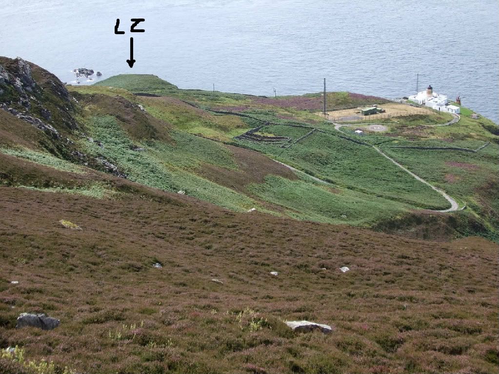
LZ Landing Theory
Walter,
You place a great value on STANs information and still persist with the LZ approach theory, when the entered Waypoints strongly suggests you are wrong.
Wpt D. N5732.42 W00402.92
Very precise, entered to two decimal places. I don,t know if it is the current recognised LZ at Inverness but it certainly looks a suitable place to land a Helo. Both on Goole Earth and Ordnance Survey.
Wpt C. N5735.02 W00402. 92
Again very precise. Just off the coast from Fort George. A feature which is big, unique and with verical extent. It is the perfect Initial Point /TAP. (They would probably have liked to use the corner of Fort George itself, but it is a bit too vertical.)
They have just defined a perfect TAP to LZ run. (IP to Tgt) for you FJ guys.
In marginal conditions you approach the TAP over the Moray Firth.
If you then set up Along / Across Track on the TANS, in effect it will offer you information as good as any SRA. ( I am pretty sure it was not authorised for instrument approaches, so you would still require VFR minimums.)
A very thorough bit of planning.
Wpt A. N5518.50 W00548.00.
A pile of rocks on a slope.
There is a marked LZ close by at N5518.39 W00548.05 and there may be others. It is very close to the entered position, but if they had gone to so much trouble at Inverness why not here?
Also, after studying the LZ, (photos and / or OSM), why not choose a run in track, use the Bearing and Distance facility on Tans to set in a TAP. This would have given them slow down points and best possible angle of approach.
Being thorough at one LZ and gash at another, makes no sense.
Waypoint A is what it seems. It is a turning point taken from a half mil LFC, and plotted within acceptable limits. They had probably never intended overflight.
I do hope that this entry does not compound my ignorance?
Last edited by dalek; 17th Jun 2009 at 14:30.