


Airfield clues to the age of a map

Guest
Posts: n/a
Airfield clues to the age of a map
I have an old fold-out road map (AA/Bartholomews 'shewing landmarks') of London and the Home Counties, which I am planning to put on Ebay.
It's not dated, and I wonder if the airfields will give a clue as to whether it's pre-war or immediately post-war.
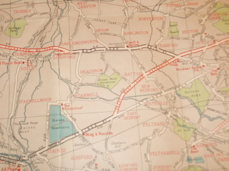
The current site of Heathrow is crossed more or less NE-SW by the B379 Oaks Road/Heathrow Road and off this, between roughly the site of Terminal 1 and Hatton Cross, runs Cain's Lane. In the area between Cain's Lane, Heathrow Road, the Duke's River and the A30 (ie nowhere near the Bath Road) is the 'Great West Aerodrome'.
Also marked as airfields are Heston and the 'London Air Park' at Hanworth.
I suspect it's pre-war. Any ideas? Thanks.
It's not dated, and I wonder if the airfields will give a clue as to whether it's pre-war or immediately post-war.
The current site of Heathrow is crossed more or less NE-SW by the B379 Oaks Road/Heathrow Road and off this, between roughly the site of Terminal 1 and Hatton Cross, runs Cain's Lane. In the area between Cain's Lane, Heathrow Road, the Duke's River and the A30 (ie nowhere near the Bath Road) is the 'Great West Aerodrome'.
Also marked as airfields are Heston and the 'London Air Park' at Hanworth.
I suspect it's pre-war. Any ideas? Thanks.
Join Date: Dec 2001
Location: Nottingham UK
Age: 85
Posts: 5,575
Likes: 0
Received 0 Likes
on
0 Posts
Hanworth Park became the test airfield of the Whitehead Aircraft Company until it was liquidated in 1919. The factory was used as motor car store, then for the construction of trams and underground railway carriages. The site was sold to the General Aircraft Company in 1935 and was used for aircraft construction throughout the war until 1948 when it closed due it being too close to the expanding Heathrow . The park is still known as "Air Park".

Join Date: Nov 2003
Location: In a good pub (I wish!)
Posts: 250
Likes: 0
Received 0 Likes
on
0 Posts
Not meaning to thread drift too much, but can anyone say when the first British air maps were produced, as against flying by AA map?
Knowing that the AA were operating an aeroplane pre-WWII, did they produce any special maps for pilots/navigators?
Knowing that the AA were operating an aeroplane pre-WWII, did they produce any special maps for pilots/navigators?
Join Date: May 2001
Location: up North
Posts: 661
Likes: 0
Received 0 Likes
on
0 Posts
Knowing that the AA were operating an aeroplane pre-WWII, did they produce any special maps for pilots/navigators?
The GAL Universal was built at Hanworth; it became the Blackburn Beverley.
Until about 1980 the old airport buildings at Heston were still used by the CAA/NATS; there may still be some T2 hangars there.
Until about 1980 the old airport buildings at Heston were still used by the CAA/NATS; there may still be some T2 hangars there.
Join Date: Dec 2003
Location: Somewhere in England.
Posts: 113
Likes: 0
Received 0 Likes
on
0 Posts
http://www.heathrow-airport-guide.co.uk/history.html gives this:
"What is now the world's busiest international airport started life as a small grass airfield. Privately owned, the Great Western Aerodrome was used largely for test flying with commercial flights taking off from nearby Heston and Hanworth Park airfields.
In 1944 it was requisitioned by the Air Ministry to be developed as a major transport base for the Royal Air Force. Before the work was completed the war ended and with it came the prospect of a huge expansion in civil aviation.
London needed a large airport with modern equipment and the partly-built site at Heathrow was ideal. One runway was ready for use and when the Ministry of Civil Aviation took it over in 1946 the tented terminal was quickly put in place and a new chapter began."
While http://www.bbc.co.uk/dna/h2g2/A4455038 adds:
"Heathrow began life in the 1930s as the Great Western Aerodrome, and took its present name from the 'Heath Row' hamlet that was destroyed to make way for the airport. Heath Row stood right in the heart of the airport site, near what is now Terminal 3.
Up to the outbreak of World War II, Heathrow was overshadowed by Croydon Airport, which was the principal airport for London at the time. However, the two-year period from 1944 to 1946 saw some questionable actions by Government ministers (specifically Harold Balfour, then Under-Secretary of State for Air) resulting in Heathrow coming firstly under the control of the Ministry of Air, and then less than two years later being handed over to Ministry of Civil Aviation (predecessor of the Civil Aviation Authority). Heathrow fully opened for civilian use on the 31 May, 1946."
On the basis of what The SSK says in his original post, it seems that the map is pre-war (or based on pre-war mapping). The key may well be whether the hamlet of Heath Row appears on his map.
P
More than just an ATCO
Join Date: Jul 1999
Location: Up someone's nose
Age: 75
Posts: 1,768
Likes: 0
Received 0 Likes
on
0 Posts
did they produce any special maps for pilots/navigators?
The map that started this thread off does indeed sound 1930s. Sometimes you can find obscure indications of the year in the printers references at the corner of a map, eg something like 2977/36/50000 leading to a guess that it is from 1936, they printed 50,000 of them (invariably done in round numbers), and the printer's job number for it was 2977.
Map makers have never liked putting year dates on them as this makes it difficult to sell them after a certain time. If you notice A-Z street maps of cities never have a prominent date on them (use the technique above for assistance).
Ordnance Survey maps are produced regularly and have accurate revision date information shown, but surprisingly up until the early 1960s airfields were regarded as "secret" and are often just shown as a white area, sometimes with a simple label, sometimes nothing at all. A 1960 1" OS map of Somerset I have shows Yeovilton as just a blank area. The same approach was taken with power stations etc which leads to lots of power transmission lines (not censored) ending up in a field. The practice of showing accurate runway and taxiway layouts on both civil and RAF airfields on OS maps is a comparatively recent innovation.
The 'Great West' airfield was operated by Fairey Aviation; I think they may have built Battles there. Faireys moved to Heston when Heathrow was developed.
Spoon PPRuNerist & Mad Inistrator
Hanworth Air Park remained as an airfield until 1946 / 47 (depending on which sources you read!). It is still effectively in a near-identical state nearly 60 years later.
The Graf Zeppelin visited it in 1932, which must have been a fascinating sight.
Heston also survived until 1946, so it is possible (though unlikely) that the map is just post WW2.
SD
The Graf Zeppelin visited it in 1932, which must have been a fascinating sight.
Heston also survived until 1946, so it is possible (though unlikely) that the map is just post WW2.
SD
As is well known the M4 motorway was built across the site of Heston airfield in the 1960s. Heston services are right on the site. The last time I was in the westbound side (the two sides of the services are quite different because the westbound side building was destroyed by fire some years ago and completely rebuilt) some quite nice photographs of the airfield in the 1930s were displayed around the place.
Guest
Posts: n/a
Well I feel a bit foolish, I just noticed in the corner 'A1940 roads revised by the Automobile Association'. Since A1940 is in red and the rest in black, I had it in mind that it referred to the A1940 road (wherever that is). On the map, 'new' roads are shown as red lines, so I assume these were the ones added in 1940 to previous editions.
Anyway, here's a not-very-successful attempt at photographing it:
Anyway, here's a not-very-successful attempt at photographing it:

Join Date: Oct 2002
Location: Surrey
Posts: 371
Likes: 0
Received 0 Likes
on
0 Posts
London Air Park
Well done with the map SSK. But I am puzzled about the position shown for London Air Park, doubly so because there seems to be a great river running across it.
About 30 years ago, every evening on the train from Waterloo, just before arriving at Feltham, the remains of what appeared to be London Air Park's terminal building were apparent by the south side of the railway. This would have been a couple of hundred yards north of the location shown on your map, on the north side of the road. All four walls were intact, but the tower on top was rapidly becoming derelict with the wooden roof in pieces, and every week the vandals did something new.
Nothing is there now; the site is now occupied by a huge Royal Mail depot.
D120A
Spoon PPRuNerist & Mad Inistrator
Hanworth Air Park is definitely in the right place on that map! The river running through it is a bit misleading, to say the least, though. As far as I know it had been culverted before the war As it is today) - although as a precaution against invasion it might have been temporarily allowed to flood?
There's some great aerial photos here of Heston, Heathrow and Hanworth (and lots more).
SD
There's some great aerial photos here of Heston, Heathrow and Hanworth (and lots more).
SD
About 30 years ago, every evening on the train from Waterloo, just before arriving at Feltham, the remains of what appeared to be London Air Park's terminal building were apparent by the south side of the railway. This would have been a couple of hundred yards north of the location shown on your map, on the north side of the road. All four walls were intact, but the tower on top was rapidly becoming derelict with the wooden roof in pieces, and every week the vandals did something new.
Nothing is there now; the site is now occupied by a huge Royal Mail depot.
D120A
Nothing is there now; the site is now occupied by a huge Royal Mail depot.
D120A
http://www.southernrailway.net/searc...arch_fd0=35323
I vaguely remember reading in Aeroplane monthly that an HP42 or similar had come to grief at Hanworth by breaking through a culvert, presumably the one covering the river mentioned above.
The main hangar was used by Aston Martin before they moved to Newport Pagnell; later they were used by a company called 'GP Speed Shop' which built 'beach buggy' bodies to fit VW Beetle chassis; the hangar was destroyed by fire mid 70s.
The main hangar was used by Aston Martin before they moved to Newport Pagnell; later they were used by a company called 'GP Speed Shop' which built 'beach buggy' bodies to fit VW Beetle chassis; the hangar was destroyed by fire mid 70s.
Ecce Homo! Loquitur...
"A bypass for Colnbrook followed after the Second World War, built across farmland between Harmondsworth and the outskirts of Langley...."
"Between the wars the Great West Road was built as a bypass to relieve traffic congestion in Brentford and Hounslow. This ran across farmland from what is now the Chiswick Roundabout, rejoining the Bath Road where the Traveller's Friend pub near Cranford used to be situated.."
So, looking at the map, it is obviously after the Great West Road was built. I would suggest that the roads in red are planned roads, not yet built, as on modern AA maps. Assuming the building of new roads, except those essential for the war effort, was deferred during the war, 1940 would seem a reasonable timeframe, before security stopped them being published.