


all of that mess with RNAV app

Thread Starter
Join Date: Jan 2009
Location: europe
Age: 41
Posts: 88
Likes: 0
Received 0 Likes
on
0 Posts
all of that mess with RNAV app
Hi everyone
Read a lot and still confused , having reflection why FAA , EASA , ICAO can't work together and use the same acronyms etc. but it's a different story.
Most of the publications says that RNAV(GPS) is the same as RNAV(GNSS) approach - the difference is just naming.
But , having two different Jeppesen app plates , two airports in Europe - one has RNAV(GNSS) label and the other RNAV(GPS)
First one EPWA RNAV(GNSS) 11 (attached)
they have LPV minimums - btw. for what they stated there CAT 1 ?
they have LNAV/VNAV minimums - if your aircraft is not approved for LPV
they have LNAV minimus - if your aircraft is not approved for LNAV/VNAV or LPV
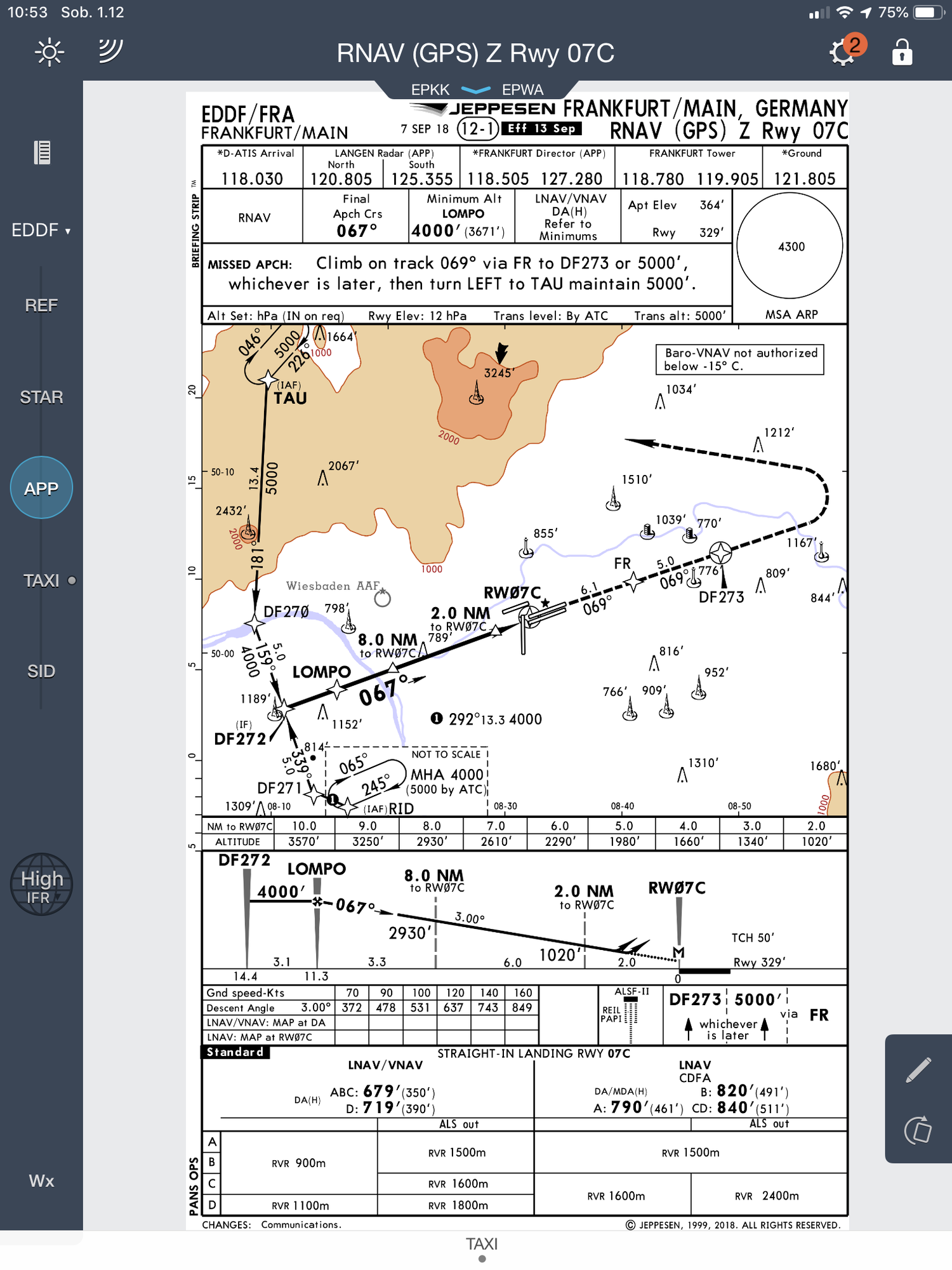
Second one EDDF RNAV(GPS)Z 07
they only have LNAV/VNAV minimums and LNAV minimus
conclusion is - if RNAV(GNSS) and RNAV(GPS) are the same , why EDDF have no LPV minimums
One more question , on EPWA plate there is EGNOS frequency added - any idea for what ?
Thanks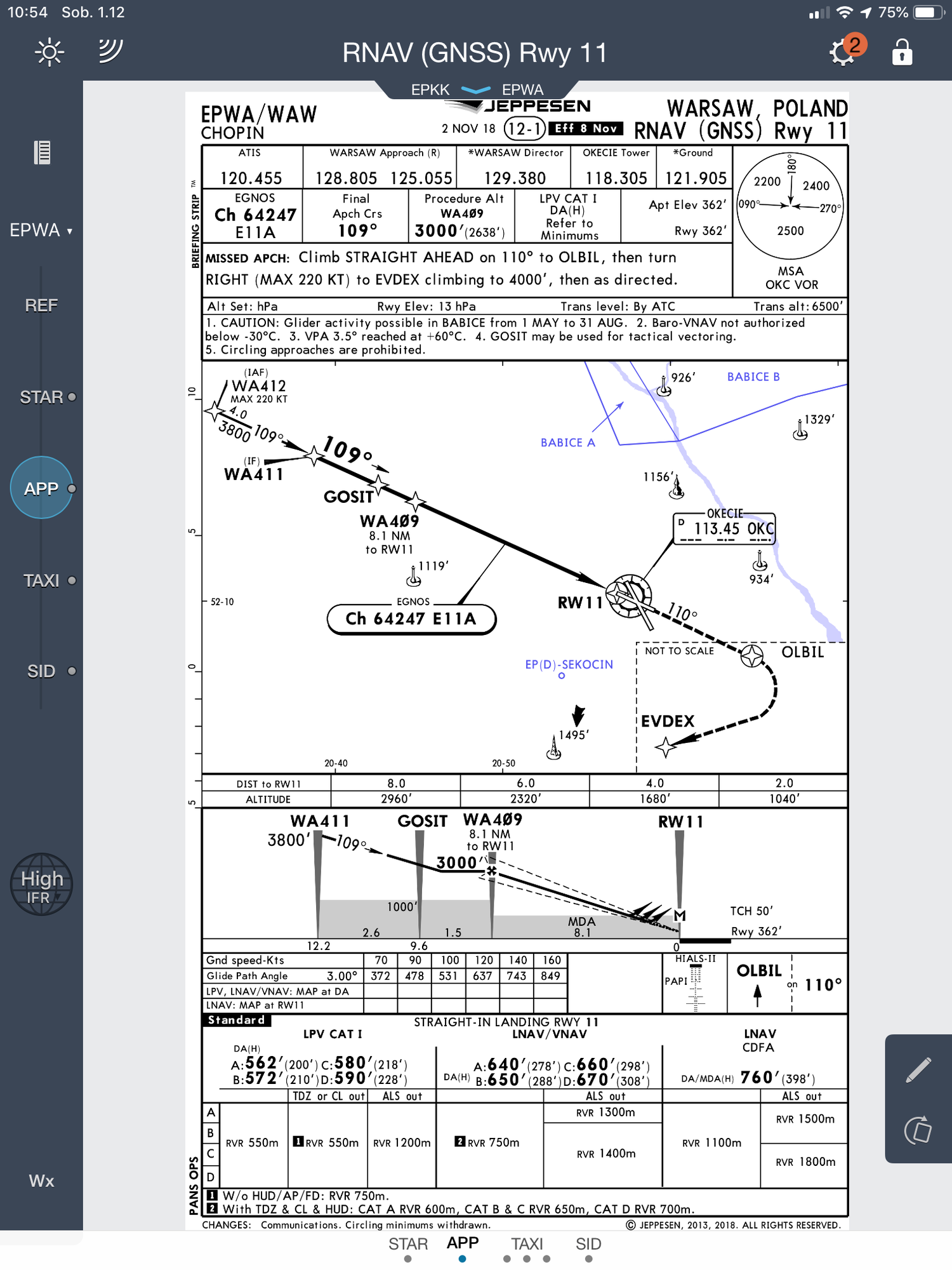
Read a lot and still confused , having reflection why FAA , EASA , ICAO can't work together and use the same acronyms etc. but it's a different story.
Most of the publications says that RNAV(GPS) is the same as RNAV(GNSS) approach - the difference is just naming.
But , having two different Jeppesen app plates , two airports in Europe - one has RNAV(GNSS) label and the other RNAV(GPS)
First one EPWA RNAV(GNSS) 11 (attached)
they have LPV minimums - btw. for what they stated there CAT 1 ?
they have LNAV/VNAV minimums - if your aircraft is not approved for LPV
they have LNAV minimus - if your aircraft is not approved for LNAV/VNAV or LPV
Second one EDDF RNAV(GPS)Z 07
they only have LNAV/VNAV minimums and LNAV minimus
conclusion is - if RNAV(GNSS) and RNAV(GPS) are the same , why EDDF have no LPV minimums
One more question , on EPWA plate there is EGNOS frequency added - any idea for what ?
Thanks

Join Date: Aug 2018
Location: Los Angeles
Posts: 8
Likes: 0
Received 0 Likes
on
0 Posts
They�re not the same
the GNSS EGNOS in Europe/ WAAS in USA have an LPV approach because use a combination of satellites that provide lateral precision and ground base station that provides vertical precision.
the LNAV/VNAV or just LNAV use just satellites, less precise
the GNSS EGNOS in Europe/ WAAS in USA have an LPV approach because use a combination of satellites that provide lateral precision and ground base station that provides vertical precision.
the LNAV/VNAV or just LNAV use just satellites, less precise
Join Date: Apr 2010
Location: London
Posts: 319
Likes: 0
Received 0 Likes
on
0 Posts
GNSS is also an 'umbrella' term for many different types of satellite-based navigation solution, GPS was the American set-up.
As for the rest - agreed, shambolic situation and utter mess that helps no single person understand with a logic applied. Typically aviation. Makes you want to vomit. Lets not start on RAW TAF's, METAR's and NOTAM - Like we still need such gibberish in required information.
As for the rest - agreed, shambolic situation and utter mess that helps no single person understand with a logic applied. Typically aviation. Makes you want to vomit. Lets not start on RAW TAF's, METAR's and NOTAM - Like we still need such gibberish in required information.
They’re not the same
the GNSS EGNOS in Europe/ WAAS in USA have an LPV approach because use a combination of satellites that provide lateral precision and ground base station that provides vertical precision.
the LNAV/VNAV or just LNAV use just satellites, less precise
the GNSS EGNOS in Europe/ WAAS in USA have an LPV approach because use a combination of satellites that provide lateral precision and ground base station that provides vertical precision.
the LNAV/VNAV or just LNAV use just satellites, less precise
SBAS requires extra geo-stationary satellites. Over the US, these provide a Wide-Area Augmentation (WAAS) signal.
Over Europe, the SBAS is called EGNOS (European Geo-stationary Navigation Overlay System).
Over India, it is called GAGAN.
These extra satellites receive a correction signal from a master ground station, which in turn receives corrections from multiple other stations, spread over a wide area, whose position is accurately known.
The correction is broadcast from the geo-stationary satellite and is receivable over a wide area by suitably-equipped GPS aircraft systems. This accurate signal allows the application of LPV minima.
GBAS is a Local Area System (LAAS) which doesn’t require an extra satellite but uses a fixed ground station to measure any errors in the raw GPS signal and broadcasts the correction to aircraft in the vicinity. This then allows the use of a GPS Landing System (GLS) which gives the pilot guidance in a very similar way to ILS.
Although Boeing aircraft are not approved for LPV approaches, some are approved for GLS approaches. I take that to mean that they are not equipped to receive the WAAS or EGNOS signal but are equipped to receive the LAAS correction.
I don’t know about Airbus.
Join Date: Jan 2004
Location: Far away from LA
Posts: 1,032
Likes: 0
Received 0 Likes
on
0 Posts
I do not want to be pedantic, but all these questions are answered during the theoretical part of the PBN.
GNSS precision is always the same, the Integrity varies hence the SBAS ( or GBAS) @Eckhard is correct on his above post.
Jeppessen has a good briefing about it, as well as Flight Safety ( for once)
Remember that you need IR-PBN endorsed for each type being flown in order to fly any of these..
GNSS precision is always the same, the Integrity varies hence the SBAS ( or GBAS) @Eckhard is correct on his above post.
Jeppessen has a good briefing about it, as well as Flight Safety ( for once)
Remember that you need IR-PBN endorsed for each type being flown in order to fly any of these..
Join Date: Oct 2001
Location: Asia
Posts: 241
Likes: 0
Received 0 Likes
on
0 Posts
Join Date: Feb 2010
Location: Slovakia
Age: 65
Posts: 162
Likes: 0
Received 0 Likes
on
0 Posts
CHR: " conclusion is - if RNAV(GNSS) and RNAV(GPS) are the same , why EDDF have no LPV minimums ".
Simple really, probably no one has bothered to design an LPV approach yet.
Simple really, probably no one has bothered to design an LPV approach yet.
