


 6th Jan 2024, 07:24 - Wikipost
|
|||
|
|||

Which Aerodrome Mk IV
Grrr.
I looked at Cheddington last night but I couldn’t see a match except for the triangular runway layout. ( the train robbery clue would have gone beyond me anyway..)
I looked at Cheddington last night but I couldn’t see a match except for the triangular runway layout. ( the train robbery clue would have gone beyond me anyway..)

NAKED RADAR
not always in this state. 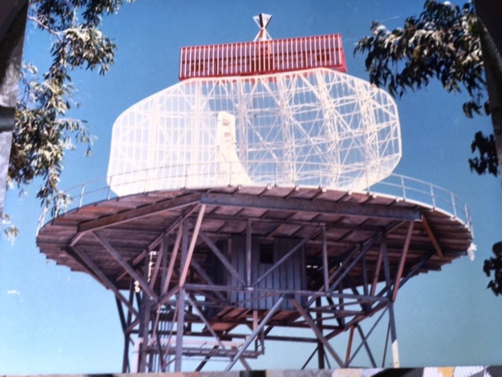
There were 2 huge ordnance depots just south of Bicester; I think they were called 'Arncott' and ''Ambrosden'; both surrounded small hills and had railway lines around them so I assume they had tunnels inside too.
"There were 2 huge ordnance depots just south of Bicester;"
https://en.wikipedia.org/wiki/MoD_Bicester
still there but up for sale I think - probably be taken over by the Shopping Village
https://en.wikipedia.org/wiki/MoD_Bicester
still there but up for sale I think - probably be taken over by the Shopping Village
Is the radar in N America?
Not North America and I have to advise the original was "auto corrected" and the sky came up that colour. It's not always that clear but the computer did not alter the shape of the leaves.
Gne
Gne
Very close to the end of the 24 hour blackout on confirming the correct answer. But with 8 minutes to go I can confirm it is not Cancun.
Gne
Gne
The radar is sited on a feature with the same name as the feature to which the Malaysian TRAD was relocated from Subang.
The airfield shares a name which is a homophone of the underlying geological formation.
Shortly after the picture in post #2022 was taken a radome was fitted.
Pictorial clue later this evening.
Gne
The airfield shares a name which is a homophone of the underlying geological formation.
Shortly after the picture in post #2022 was taken a radome was fitted.
Pictorial clue later this evening.
Gne
Not Guarani. The subject airport is about 600nm north and a very long way west of there. It is also 185m higher in elevation. The great circle route between the two would take you almost directly over the south pole.
Gne
Gne
600 nm north takes us to 15ş 27' S and over the pole takes us to WA. How about Kununurra?
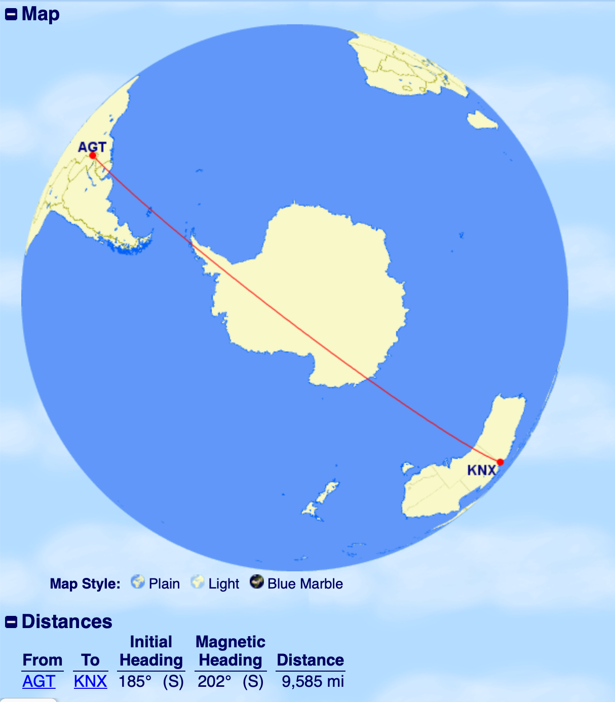
"almost" there and "about" the correct region but you missed the actual metric in the clue. Getting close so I'll hold off on the visual clue.
Gne
Gne
Yes, I realized after I posted that the elevation was wrong!
Way too far south.
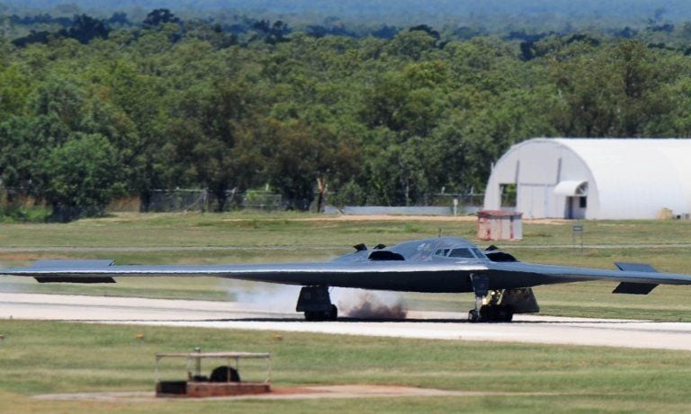
Here's a picture from the tower.
Gne.
Here's a picture from the tower.
Gne.
That's probably Tindal, which I considered, but the elevation doesn't fit your clue.
Yes, it is Tindal and my inexcusable mistake in getting the elevation data wrong. Can't even blame too much red - just late at night and used m for one and ft for the other in cross checking data on the 'net. Abject apologies - but you got the cup in the end.
Here's another picture, this time with the tower in view.
The radar pic was taken in 1988 during the acceptance process before the radome was fitted. The site in Hill 33 and I was surprised to find that the Malaysian TRAD relocation was to a similarly named feature when we deployed for the acceptance trails there 15 years later

. .
Here's another picture, this time with the tower in view.
The radar pic was taken in 1988 during the acceptance process before the radome was fitted. The site in Hill 33 and I was surprised to find that the Malaysian TRAD relocation was to a similarly named feature when we deployed for the acceptance trails there 15 years later
. .
Thank you Gne. I scoured the NT looking for high-elevation aerodromes!
I was aware of RAAF Tindal, but I didn't actually know where it was! Looking at GE, I was intrigued by the layout of the aircraft shelters.
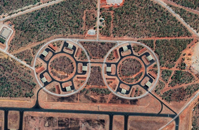
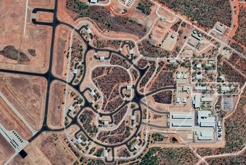
No doubt that it is in the "Red Centre"!
Where is this one? Definitely not very high!
I was aware of RAAF Tindal, but I didn't actually know where it was! Looking at GE, I was intrigued by the layout of the aircraft shelters.
No doubt that it is in the "Red Centre"!
Where is this one? Definitely not very high!
Last edited by India Four Two; 30th Jan 2023 at 03:02.