


Epsom NDB - did it move?

Join Date: Aug 1999
Location: Too Far North
Posts: 1,105
Likes: 0
Received 0 Likes
on
0 Posts
I've just spotted Epsom hiding at the bottom of this...
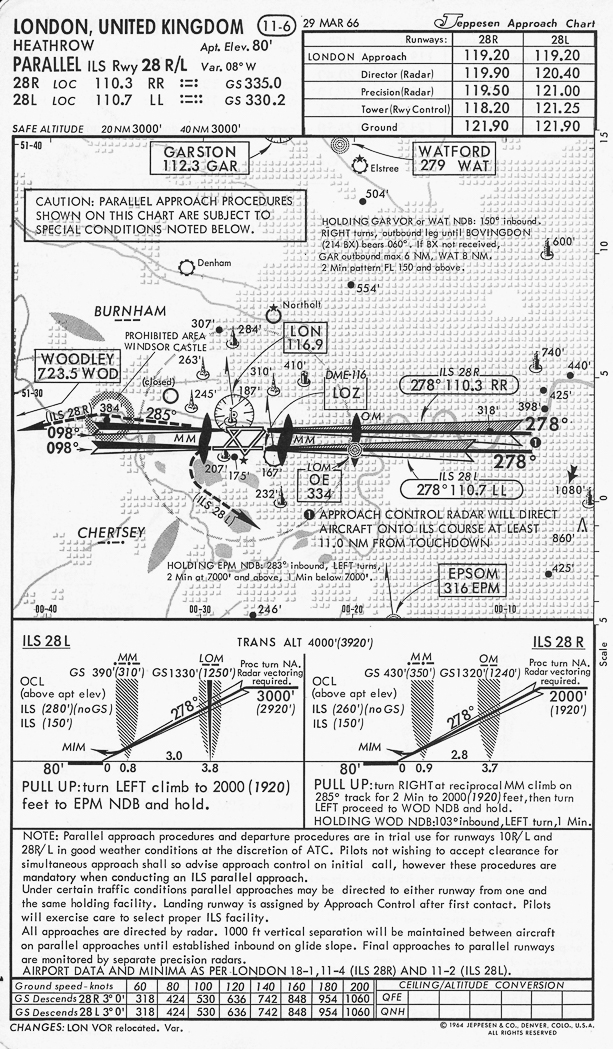
Taking the LAT/LONG off that as 51.20N 000.17W puts it just east of my previous plots (pink pin) so I think we can safely say it has moved.
As to when it moved, I think we can assume that it was in its original position when Lord Trefgarne asked his question in Feb 1968 and the co-ordinates provided by Discorde from Nov 1969 has it in the current position (allowing for datum change) so sometime in that window.
Last edited by Flap40; 11th Mar 2021 at 12:10.

Bearing in mind those coordinates are to the nearest minute, the potential error is up to +/- 3000 feet N-S and 1900 feet E-W, and then you need to offset the bounding box by around 400 feet to account for the OSGB36 to WGS84 offset.
But it's definitely in a different place from its current location.

Last edited by DaveReidUK; 11th Mar 2021 at 14:08.
Since there has been mention of radio ranges, I thought I would look for a picture of the antenna layout. I could only find one picture - an anonymous US one:
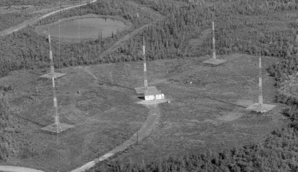
There were still some operational ones in Canada in the early 70s.
There were still some operational ones in Canada in the early 70s.
Gnome de PPRuNe
Join Date: Jan 2002
Location: Too close to Croydon for comfort
Age: 60
Posts: 12,595
Received 275 Likes
on
153 Posts

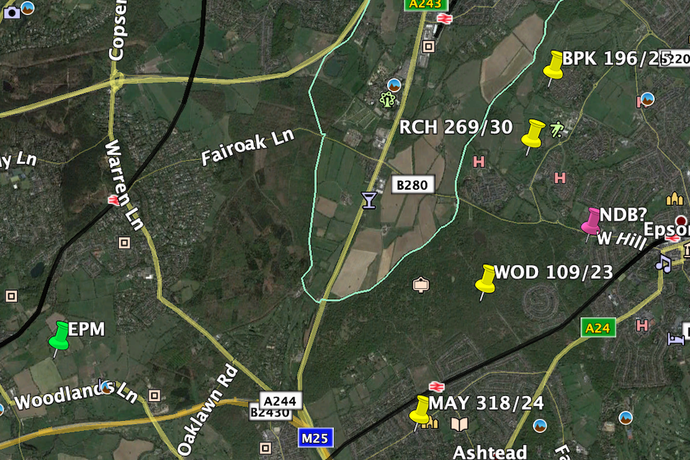
Dave can you confirm those co-ords please, I was just using Bing's Ordinance Survey map to pinpoint where it would have been sited and that places it in South Earlswood, just west of Redhill Aerodrome and about 10 miles SSE: 51.209683, -0.170325...
My coordinates from the AIP are degrees and minutes, yours are degrees and decimal degrees. So N 51� 21' would equate to 51.35 degrees, for example.
As it happens, I've just been playing around with a conversion from OSGB lat/lon to OS Grid, and produced this bounding box based on the AIP coordinates:
Height and width are 1 minute of latitude and longitude, respectively, centre of the box is the above-quoted coordinates.
As for whether there is any discernable sign of the radio range remaining today, we would be looking for 4 points spaced more-or-less equidistantly around a 600 foot diameter circle.
Here's an example of one in the USA from GE - it looks like somebody has helpfully planted trees in the holes vacated by the antennae.
The Epsom one may well be under housing, or the golf course.
Gnome de PPRuNe
Join Date: Jan 2002
Location: Too close to Croydon for comfort
Age: 60
Posts: 12,595
Received 275 Likes
on
153 Posts
Ahhhhhhhh! Bloody decimals... I couldn't see how it could be THAT far wrong... Your box is roughly where I expected it to be and I was looking at old maps yesterday to see if it was marked (current OS 1/25000 maps certainly show VORs).
Incidentally, the three housing estates in the lower half of the box are all former mental hospital sites - there were five more or less adjacent to one another so I think the beacon would most likely be on the golf course site.
Incidentally, the three housing estates in the lower half of the box are all former mental hospital sites - there were five more or less adjacent to one another so I think the beacon would most likely be on the golf course site.
The chart is dated May 1968, so it must have moved some time before then.

Thread Starter
Join Date: Mar 2021
Location: UK
Posts: 3
Likes: 0
Received 0 Likes
on
0 Posts
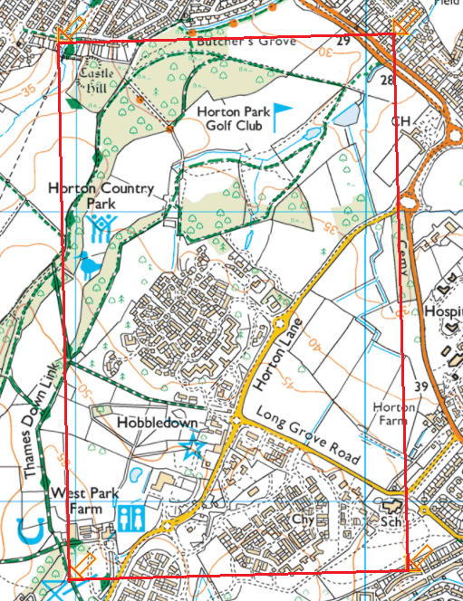
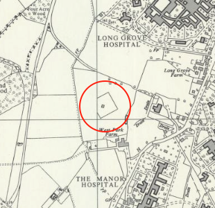
Thank you all for your interest and fascinating comments and nuggets information e.g. the EPM holding pattern, difference between OSGB36 and WGS84 and radio ranges. Especial thanks to Flap40 for great geometry and DaveReid and Discorde for their research. Belatedly, seeing those pins on the map reminded me of something which I had overlooked, having become fixated on my Epsom Downs theory. I used to live on the west side of Epsom and walked frequently in the former mental hospitals cluster. I vaguely recall a small brick building in the then farmland between West Park and Long Grove Hospitals. Also, I recall, but can't find, mention on local maps of a radio station in this vicinity. After a bit of digging (thank you National Library of Scotland!) I found an OS map published in 1962 showing a small fenced building at TQ 190 620. TQ 19 62 is the whole 1km grid square within DaveReidUK's red oblong so bottom left of that!
I've twice tried to send this post with a JPG of part of the OS map only for it to be rejected for apparently including a URL. Rather than risk it again I'll post the JPG separately.
Thanks again everyone!
I've twice tried to send this post with a JPG of part of the OS map only for it to be rejected for apparently including a URL. Rather than risk it again I'll post the JPG separately.
Thanks again everyone!
Ockham85,
You won't be able to post URLs or images until you have ten posts. Here's the location you were referring to:
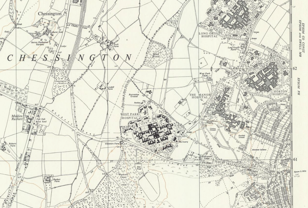
Here's the map URL: https://maps.nls.uk/view/189258746 (Sheet TQ 16 SE, Six Inches to the Mile, 1962). The NLS site is a truly wonderful resource if you like old maps.
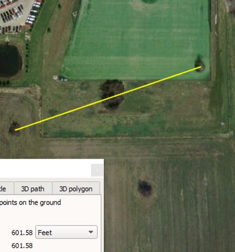
I estimated the 10m grid reference as TQ19036206 and converted it to WGS84 Lat/Long:
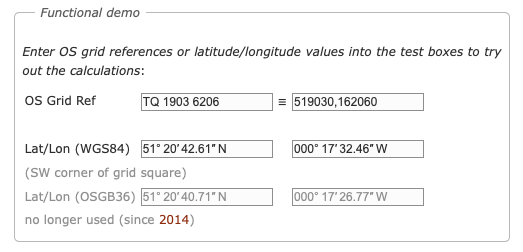
http://www.movable-type.co.uk/script...s-gridref.html
and then entered the Lat/Long into Google Earth:

If you zoom in, you can see the outline of the foundations!
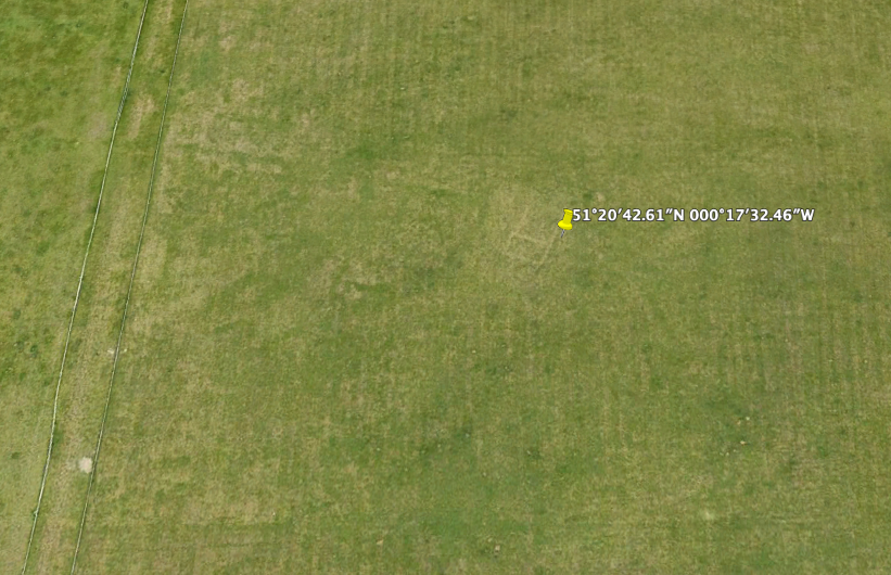
PS I have just noticed that the conversion website gave me the OSGB36 Lat/Longs as well. If you assume they are WGS84 coordinates and plot them on Google Earth, you would have a point 59 m S and 110 m W of the true position.
You won't be able to post URLs or images until you have ten posts. Here's the location you were referring to:
Here's the map URL: https://maps.nls.uk/view/189258746 (Sheet TQ 16 SE, Six Inches to the Mile, 1962). The NLS site is a truly wonderful resource if you like old maps.
I estimated the 10m grid reference as TQ19036206 and converted it to WGS84 Lat/Long:
http://www.movable-type.co.uk/script...s-gridref.html
and then entered the Lat/Long into Google Earth:
If you zoom in, you can see the outline of the foundations!
PS I have just noticed that the conversion website gave me the OSGB36 Lat/Longs as well. If you assume they are WGS84 coordinates and plot them on Google Earth, you would have a point 59 m S and 110 m W of the true position.
Last edited by India Four Two; 13th Mar 2021 at 01:42.
Gnome de PPRuNe
Join Date: Jan 2002
Location: Too close to Croydon for comfort
Age: 60
Posts: 12,595
Received 275 Likes
on
153 Posts
The line of trees on the western side of that field is the route of the Thames-Down Link national path from Tolworth to Dorking, which I walked a few years ago... Had I known then...
EPM is also a waypoint on the westerly Detling SIDs.
Congratulations - great bit of detective work !
The rectangle on the map (strangely truncated by the grid line) presumably marked a wall or fence around the central antenna and hut. I suspect that by 1960 the radio range had been dismantled, leaving only the NDB, but if I'm not mistaken the orientation of the fence/wall matches the orientation of the original radio range beams. The Epsom beams were more-or-less at 90� to each other (though that wasn't necessarily the case for all radio ranges).
So the original four antennae would have been outside the rectangle, but in line with its vertices. Sadly, no trees planted in the holes.
Avoid imitations
Join Date: Nov 2000
Location: Wandering the FIR and cyberspace often at highly unsociable times
Posts: 14,573
Received 413 Likes
on
218 Posts
Indeed, they look like not a lot more than a garden shed.
The rectangle on the map (strangely truncated by the grid line) presumably marked a wall or fence around the central antenna and hut.
Gnome de PPRuNe
Join Date: Jan 2002
Location: Too close to Croydon for comfort
Age: 60
Posts: 12,595
Received 275 Likes
on
153 Posts
Join Date: Oct 2004
Location: Southern England
Posts: 478
Likes: 0
Received 0 Likes
on
0 Posts
The current site for EPM would be totally unsuitable for a Radio Range so it must have been on a different site at that time especially as the current building would not have been big enough to accommodate the range transmitters.
I have no knowledge of the Radio Range at Epsom, it predates me by many years, but at Dunsfold the Radio Range was converted into an NDB by retaining the original building and using the Range Mast nearest the building for the aerial. That arrangement continued until the early 80s when the remaining mast was condemned and replaced with the type of aerial now seen at EPM. The Dunsfold Range Building consisted of an equipment room next to a generator room with a firewall between the two which looks remarkably similar to the outline of the foundations in that field.
Originally at its current site EPM would have used a wire antenna strung between two fairly tall masts/poles either end of the compound. There aren't many en-route NDBs left but the building at EPM is at least brick built. Recent Google Map pictures of Westcott show something more akin to a horsebox.
Join Date: Sep 2006
Location: any town as retired.
Posts: 2,182
Likes: 0
Received 0 Likes
on
0 Posts
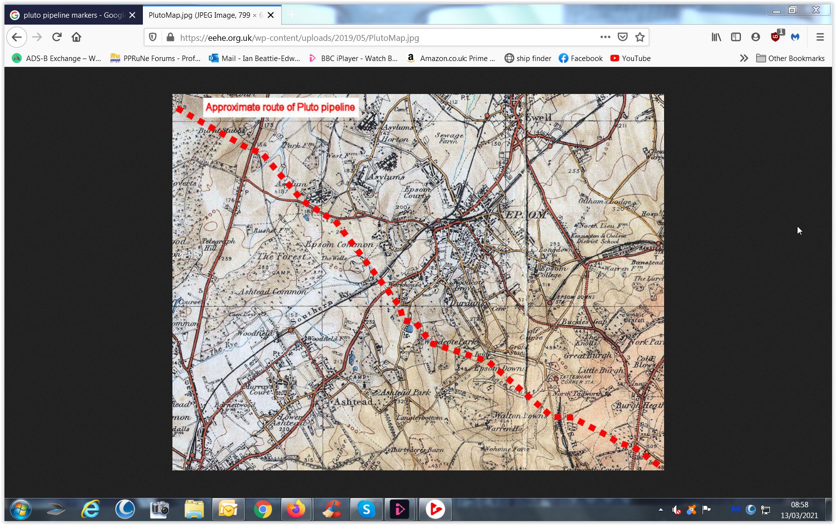
Very close to the NDB was The Barwell Trading Estate where I spent many happy years employed in the family business. I also flew into the nearby farm strip in a Rallye Club and the (brave or insane) in a single Commanche. The brief for landing was 'just don't overfly the several mental homes for fear of disturbance!'. I was also told that the wartime PLUTO pipeline ran very close to both the farm and Trading Estate and I've attached an interesting reference to that. RAF Chessington (grass strip) was also very close but I was defeated in my efforts to fly in there!
Gnome de PPRuNe
Join Date: Jan 2002
Location: Too close to Croydon for comfort
Age: 60
Posts: 12,595
Received 275 Likes
on
153 Posts
The Rushetts Farm strip in a Comanche must have been quite interesting - from memory several Pitts Specials came to grief there when visiting for maintenance by the late Geoff Masterton. I think one was fatal...

