


Question about Tallboy/Grand Slam bombs

Join Date: Dec 2001
Location: Richmond Texas
Posts: 305
Likes: 0
Received 0 Likes
on
0 Posts
3700ft/sec is probably a good number for terminal velocity. The problem would be getting a Lanc to 220000 ft to drop it.
After an excellent landing you can use the airplane again!
After an excellent landing you can use the airplane again!

Join Date: Dec 2007
Location: manchester
Posts: 80
Likes: 0
Received 0 Likes
on
0 Posts
Tallboy Bomb
Further to my previous post 12 , Dambusters also explains that the depth of penetration into the earth , dependant on fuse setting ,was estimated to be capable of displacing one million cubic feet of earth whilst creating a crater requiring five thousand tons of earth to backfill.
Some muckspreader ,could spoil ones day if dropped in ones backyard !!
Some muckspreader ,could spoil ones day if dropped in ones backyard !!
Join Date: Apr 2007
Location: moraira,spain-Norfolk, UK
Age: 82
Posts: 389
Likes: 0
Received 0 Likes
on
0 Posts
Grand Slam
As a schoolboy in Wilhelmshaven after ww2 It was possible to go to many places that Health & Safety would have had a fit about these days. I was shown a hole in the top of the U-boat pens supposedly made by a Grand Slam bomb which subsequently exploded deep underground. Also remember the Army engineers detonating some dangerous explosive
which caused most of the remaining windows in that part of town to shatter. Apparently they forgot to inform the locals what they were up to.
which caused most of the remaining windows in that part of town to shatter. Apparently they forgot to inform the locals what they were up to.

Join Date: Dec 1999
Location: UK
Posts: 2,584
Likes: 0
Received 0 Likes
on
0 Posts
50�55'32.80"N 1�43'3.00"W. (New Forest)
Pop that into Google Earth and see how big that hole is...the pond inside it is 50 x 60 ft! What else could have made that but a Grandslam, and they were tested there apparently.
Pop that into Google Earth and see how big that hole is...the pond inside it is 50 x 60 ft! What else could have made that but a Grandslam, and they were tested there apparently.

Join Date: Apr 2002
Location: Nirvana South
Posts: 734
Likes: 0
Received 0 Likes
on
0 Posts
"Tested" may be a bit of an exaggeration but there was a Grand Slam outside the museum at Fort Lewis, Washington State in the 80s. It was found on the ranges. My guess is that it was from B-17 trials & was jettisoned.
I seem to remember that it was not the blast itself but the shock wave produced that caused the main damage such that a near miss could do more than a direct hit. Barnes Wallis thought it up after he heard that shock waves from driving pilings was causing collateral damage at a site in London.
I seem to remember that it was not the blast itself but the shock wave produced that caused the main damage such that a near miss could do more than a direct hit. Barnes Wallis thought it up after he heard that shock waves from driving pilings was causing collateral damage at a site in London.
My guess is that there is more chance of a Grand Slam getting airborne with a B-17 slung underneath, than a B-17 getting airborne with a Grand Slam. the largest bomb carried by the B-17 was 2000lb.


Cunning Artificer
Join Date: Jun 2001
Location: The spiritual home of DeHavilland
Age: 76
Posts: 3,127
Likes: 0
Received 0 Likes
on
0 Posts
Gravity is not thrust, it is a fixed rate of acceleration and is totally independant of the mass of the object
Join Date: May 2010
Location: Illinois USA
Age: 82
Posts: 10
Likes: 0
Received 0 Likes
on
0 Posts
Ayn idea of the name of the air base just north of the above site
50�55'32.80"N 1�43'3.00"W - Google Maps
Just curious
50�55'32.80"N 1�43'3.00"W - Google Maps
Just curious
TCraft41, Welcome to PPRuNe.
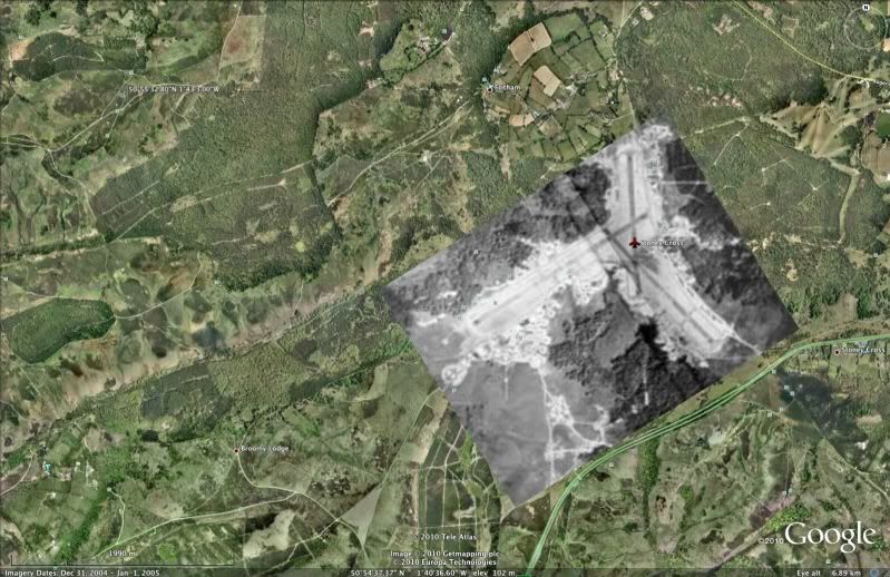
As StbdD said, it's Stoney Cross - a disused wartime airfield, which is used as a Visual Reporting Point for VFR traffic skulking round the edge of the "busy" Bournemouth zone.
IF you are interested in UK airfields, download this Google Earth 'kmz' file:
http://www.rickdavis.co.uk/home/UKAirfields.kmz
Here's the whole of the UK:

Another interesting 'kmz' file that I found recently is http://is.gd/hAMrD
which contains old aerial photos of airfields.
Here's the one for Stoney Cross (with Ab's Grand Slam crater in the top left corner):
As StbdD said, it's Stoney Cross - a disused wartime airfield, which is used as a Visual Reporting Point for VFR traffic skulking round the edge of the "busy" Bournemouth zone.
IF you are interested in UK airfields, download this Google Earth 'kmz' file:
http://www.rickdavis.co.uk/home/UKAirfields.kmz
Here's the whole of the UK:
Another interesting 'kmz' file that I found recently is http://is.gd/hAMrD
which contains old aerial photos of airfields.
Here's the one for Stoney Cross (with Ab's Grand Slam crater in the top left corner):
Join Date: May 2010
Location: EU
Age: 82
Posts: 5,505
Likes: 0
Received 0 Likes
on
0 Posts
I42
I tried to "load" the second kmz, bur without visible success. Any ideas? (I run a Mac, could that be a glitch?)
The Rick Davis stuff I have and it works perfectly.
Reg
I tried to "load" the second kmz, bur without visible success. Any ideas? (I run a Mac, could that be a glitch?)
The Rick Davis stuff I have and it works perfectly.
Reg
Join Date: Oct 2000
Location: Bristol
Posts: 461
Likes: 0
Received 0 Likes
on
0 Posts
There's confidence for you! At school I was taught that gravity is the force of attraction between two masses and was proportional to the masses of the two objects and their distance apart.
On the earth the gravitational force is sufficient to give an object an acceleration toward earth's center of 32ft/sec/sec (roughly)
Dick
Sorry, I'm a page out of date. I was replying to Ag. bis.
On the earth the gravitational force is sufficient to give an object an acceleration toward earth's center of 32ft/sec/sec (roughly)
Dick
Sorry, I'm a page out of date. I was replying to Ag. bis.
Last edited by Dick Whittingham; 22nd Nov 2010 at 16:14.
RegDep,
I have a Mac too, so that is not the problem.
I clicked on the link I posted and downloaded the file directly to GE, but I noticed that it wasn't automatically turned on. Look at the bottom of the Places list, under Temporary Places. You should see 'airfield overlays28-1.kmz'. Click the box to turn it on.
PM me if you cannot get it to work.
Join Date: May 2010
Location: Illinois USA
Age: 82
Posts: 10
Likes: 0
Received 0 Likes
on
0 Posts
India Four Two
Thanks.
Besides just a historical interest of England I am friends with an Eighth Air Force vet of WW II. B-17 waist gunner with 50 plus missions.
I am trying to get him to record his war memories before it is too late. It may already be as he is having problems remembering exactly where he was based in England.
The Google location should help.