


MH370 - "new" news

GBO’s claim that loss of air data input to the Left transponder, as a result of the loss of air data from the left AIMS cabinet alone, would result in the monitoring system automatically disabling all Left transponder functions, is easily testable. If true, I’d suggest it’s not a sensible design.

If the left transponder is set as the primary transponder, then the normal source of air data is from the left AIMS cabinet. If that data input is lost, the transponder does NOT switch automatically to the alternate source in the right AIMS cabinet, it requires the crew to manually switch via the ALT SOURCE switch on the transponder panel.
If an oxygen bottle has ruptured in flight destroying the P105 left wire integration panel/left ARINC 429 bus/left AIMS, then considering all the overwhelming failures associated (electrical, flight controls, pressurisation, navigation, communications, displays, etc), switching transponder or air data sources would not be the first priority.
Startle effect, cognitive overload and cognitive tunnelling would be highly likely following an oxygen bottle rupture inflight. Items will be missed.

If the left transponder is set as the primary transponder, then the normal source of air data is from the left AIMS cabinet. If that data input is lost, the transponder does NOT switch automatically to the alternate source in the right AIMS cabinet, it requires the crew to manually switch via the ALT SOURCE switch on the transponder panel.
The following users liked this post:
Capt Kremin
I�ve been researching other possible flight routes that track to the South Pole. I conclude that the UGIB (2020) route by Bobby Ulich/Richard Godfrey/Victor Iannello/Andrew Banks is the best candidate to match the satellite data.
However, the UGIB route requires EXTENSIVE changes in speed, altitude and manoeuvring to get to the starting point of 6N 93.788E.
They estimate, as do I, that due to insufficient fuel, the UGIB route still requires the bleed air system to be off for at least 4.5 hours.
The UGIB route of 2020 ends at 34.3S 93.8E, which is in the same area as the diversion to Banda Aceh route via NILAM-SANOB, as proposed in 2016!
The control �switchology� is a bit more complex mystery, for some of the reasons set out in Mick�s post.
There�s little doubt that in an �old� system with a transponder control switch that actually makes/breaks electrical contacts that include contacts that open circuit the power input, either directly or through a relay, switching it from �anywhere� to �off� would not result in a �graceful� stepping through switch position functions on the way to �off� if the switch is �abruptly� turned to �off�. But this is probably a control switch that just sends 1 or 0, when rotated, to the input of a logic gate in or on the way to an input of a microprocessor, and does not itself turn off electrical power to the transponder. It may be that this system does go through a �graceful� stepping through of switch position functions on the way to shutting down entirely when �abruptly� switched to �off�. Again, I would have thought this was easily testable, if not easily explainable by someone with a modicum of knowledge about the design and function of the specific avionics.
It would also be interesting to find out what the �raw� transponder responses to the SSR from the aircraft were. The �basic� function (I won�t say �primary�, as that would be confusing) of a transponder has been the same since before Mode C and ADS were invented.
Last edited by Lead Balloon; 23rd Jan 2023 at 03:16.
The ending point and final straight line route segment proposed in the UGIB paper are based on the satellite data and fuel modelling. That final route segment is NOT dependent on the preceding flight path. The preceding flight path was only included to show there is at least one solution that could link the initial flight path (ie the radar observations) with the final route segment derived from the satellite data. It was not proposed as the ONLY solution that could do so.
Just to be clear, GBO: Are you saying that the failure of the air data input to a transponder on this aircraft - whatever the source/s of that data - would result in the system disabling ALL functions of that transponder?
Last edited by Lead Balloon; 22nd Jan 2023 at 23:47.
Join Date: Jun 2009
Location: Crawley
Age: 70
Posts: 4
Likes: 0
Received 0 Likes
on
0 Posts
Egypt air ground fire Cairo
BuzzBox
If the left transponder is set as the primary transponder, then the normal source of air data is from the left AIMS cabinet. If that data input is lost, the transponder does NOT switch automatically to the alternate source in the right AIMS cabinet, it requires the crew to manually switch via the ALT SOURCE switch on the transponder panel.
If an oxygen bottle has ruptured in flight destroying the P105 left wire integration panel/left ARINC 429 bus/left AIMS, then considering all the overwhelming failures associated (electrical, flight controls, pressurisation, navigation, communications, displays, etc), switching transponder or air data sources would not be the first priority.
Startle effect, cognitive overload and cognitive tunnelling would be highly likely following an oxygen bottle rupture inflight. Items will be missed.
Quite likely the crew would have to vacate the flight deck.
What are your thoughts on this?
PE
Has anybody any of you Wonderful aviation gentleman gone back and had a close look at the Egypt air fire on the ground at Cairo an Oxygen fire in the cockpit burnt through the side of the cockpit and also destroyed or damaged
GBO this
Nice. A damaged P105/Left AIMS cabinet would sever the link between the left AIMS and the left transponder/right AIMS. No wonder it failed.
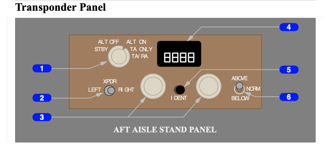
The following diagram is from the MAS B777 FCOM. Kindly indicate the "ALT SOURCE" switch.
In summary, of the possible flightpaths to the southern Indian Ocean, be it slightly west of Banda Aceh (requires an active pilot to repower SATCOM and for extensive manoeuvring) or the simple flightpath OVER Banda Aceh (aircraft on autopilot with failed left high gain antenna, unresponsive crew and serviceable right high gain antenna), statistically the endpoint is basically the same spot, 34S 93E.
The manoeuvring north of Sumatra would be depicted by multiple primary radar sites. However, the withheld primary radar recordings at Sabang ( 5�53'14"N 95�13'42"E), Lhokseumawe and Phuket ( 7�52'52"N 98�18'59"E) are not actually needed.
Nor is any CCTV footage at Banda Aceh.
Nor any mobile phone logons at Banda Aceh.
All that is needed is someone to complete the search as suggested in the ATSB�s First Principles Review 2-4 November 2016, Figure 11.

Answered questions or not, I think you'd all agree the thread's been entertaining and quite successful at stringing along the punters.
As with The X Files, if Mulder answered all the questions the air of mystique might be lost.
Now that it's been solved we can safely leave it in the hands of the relevant search organisation or authorities to dredge up the wreck.
The real question now is - what next? MH17? How did their flight planning organisation send them through or in proximity to a war zone? Or did they? Who was really behind that process?
