


Mt Erebus Disaster 40th Anniversary

Join Date: May 2016
Location: Auckalnd
Posts: 154
Likes: 0
Received 0 Likes
on
0 Posts
Compressor Stall - but the existence of "whiteout" as an optical illusion - even if it existed - still doesn't excuse the pilots!
Every pilot knows - including them - that if you're at only 1500' with a cloud layer above you, ice below you, and rising ground ahead of you - you won't see it. So by descending to this level below cloud and above ice (and not taking any one of several earlier opportunities to abort the descent) Collins had 100% total faith that he was at the entrance to Mc Murdo. And that was simply not justified.
Sure, if at 1500' they were subject to some dastardly optical illusion that made it look like they were in perfect VFR with nothing but flat ice ahead of them; that sealed their fate. But the bad decisions had already been made.

Whispering "T" Jet
"......................... But the bad decisions had already been made."
Two actually, changing the position of the final way point and not telling the crew.
Two actually, changing the position of the final way point and not telling the crew.
Join Date: Apr 2004
Location: blue earth
Posts: 227
Likes: 0
Received 0 Likes
on
0 Posts
This accident was another classic example of a whole series of errors, omissions, poor procedures, lack of training, weather conditions, commercial pressures and really poor decision making coming together to create the disaster that occured on the afternoon of 28 November 1979.
Yes, the crew of TE-901 descended below the minimum safe altitude on the 28 November 1979 - but then so too had a number of other crews during previous Antarctic flights - all to give their passengers the best possible experience in seeing the wonders of the Antarctic environment. I doubt that Collins would have been foolish enough to have deliberately descend below the minimum safe altitude if he knew that Erebus was directly in front of his current flight track, and if he fully understood what white-out phenomena was. Brooks seemed to be the only one on the flightdeck that showed any real concern for the location of any high ground in the area (i.e. Erebus) - the rest seemed to be going along with Mulgrew's interpretation of what he was seeing out of the window.
Air New Zealand management .... we haven't forgotten you bunch of Criminals, Breaking into people's homes and destroying evidence and with Air N.Z.'s denial that they promoted the flight on the low level flyover around Erebus, certainly showed the company's actions to be "orchestrated" and deceitful, in trying to move the blame from themselves, and place it squarely on the flight crew. The crew were scapegoat as often happens.
In the end, no one really came out of this whole saga looking very good at all - especially a number of personnel from Air New Zealand for their handling of the situation in the aftermath of the disaster.
Join Date: Oct 2013
Location: New Zealand
Age: 71
Posts: 1,475
Likes: 0
Received 0 Likes
on
0 Posts
Join Date: May 2016
Location: Auckalnd
Posts: 154
Likes: 0
Received 0 Likes
on
0 Posts
If you need further evidence that these pilots weren't really situationally aware, and never really had a clear mental picture of their location, consider this. If they were where they supposedly thought they were, one of their orbits would have taken them very close to Mt Bird. A pilot flying VFR who knew precisely where he was would have identified this. "Need to maintain clearance of Mt Bird/ no current visual on Mt Bird" etc. etc. But no reference to Mt. Bird was ever made.

Join Date: Nov 2019
Location: Paraparaumu
Posts: 0
Likes: 0
Received 0 Likes
on
0 Posts
Captain Fathom, no, no knowledge of who Ampan is. But I believe Bob Thomson with his experience of Antarctic travel summed up the situation very well. Here are some of his qualifications to make these statements.
But Thomson had more experience in the area than almost anybody else. During his 75 trips to Antarctica in the course of a long career with the DSIR Antarctic division, at least 50 had been on the flight deck of aircraft approaching from the north, observing the ice edge and conditions. He was the commentator on Air New Zealand's inaugural flight back in February 1977, with Captain Ian Gemmel in command, and also on the last completed trip before flight 901 on 28 November.
In fact he was originally scheduled to fly on the fatal flight, but had to change his plans because of an expected visit to Scott Base by Prime Minister Robert Muldoon in early December 1979. Instead mountaineer Peter Mulgrew took his place--and was on the flight deck nof ZK-NZP at the moment of impact.
Has Bob Thomson ever felt uneasy that, but for a twist in fate, he might have died that day?Not at all. I always insisted on a complete circuit of Ross Island before letting down below 17,000ft, that way I could get an idea of the complete situation and what the weather was like, where any clouds were.
" There is traditionally bad weather in Lewis Bay where they crashed" says Thomson
The captain didn't give attention to problems that he might have around there. These people were taking a Sunday drive. When I heard the transcript of the CVR I fell out of my chair. Most of the times Mulgrew had been there he'd gone in by sea, and all his travel from Scott Base was to the South. Hardly anybody ever went into Lewis Bay.
Had they orbited Ross Island they would have seen the cloud. If a pilot is unsure he always goes up, never down. The co-pilot of Flight 901 never opened his flight bag to look up the coordinates. I always had a chart in the cockpit and checked the latitude and longtitude readout, but the crew of the fatal flight never referred to it" . That was taken from John King Publication New Zealand Tragedies Aviation
That to me, from someone with that level of experience in AntArctic operations, and in the flight deck, even if not as operating crew, gives a far more accurate picture of events than Mahon version.
I may have said this before but I am firmly of the opinion that Mulgrew's presence on the flight deck was a major distraction and the seat should have been occupied by Brick.
Two actually, changing the position of the final way point and not telling the crew.
If we combine all of those factors, we get a picture of why the accident happened, if we decide to ignore either the company mistakes, or the pilot mistakes, we get an inaccurate picture of why the crash happened.
Join Date: May 2016
Location: Auckalnd
Posts: 154
Likes: 0
Received 0 Likes
on
0 Posts
and descending below MSA, to 1500ft, at 260kts, in an area you have never been to before, with met conditions that prompt you to say �actually it doesn�t look very good up here�, after being told that the conditions for sightseeing were unsuitable, and without getting the radar ID and let down that was in the pipeline.
If we combine all of those factors, we get a picture of why the accident happened, if we decide to ignore either the company mistakes, or the pilot mistakes, we get an inaccurate picture of why the crash happened.
Join Date: Jun 2001
Location: Rockytop, Tennessee, USA
Posts: 5,898
Likes: 0
Received 1 Like
on
1 Post
and descending below MSA, to 1500ft, at 260kts, in an area you have never been to before, with met conditions that prompt you to say �actually it doesn�t look very good up here�, after being told that the conditions for sightseeing were unsuitable, and without getting the radar ID and let down that was in the pipeline.
I agree.
The Erebus tragedy was the subject of two official reports, the first of which blamed pilot error, while the second blamed Air New Zealand's navigation system, [Prime Minister Jacinda] Ardern said.
While the latter inquiry was marred with accusations of conspiracy and false information, no challenge was made to the finding that "convincingly clears" the pilot and first officer of the plane.
"The pilots were not responsible for this tragedy, I stand here today to state that again," Ardern said.
https://www.stuff.co.nz/national/117746516/prime-minister-jacinda-ardern-apologises-for-air-new-zealand-erebus-tragedy-at-40th-anniversary-event
What would be the political motivation for the Prime Minister's statement that the pilots were not responsible? Is she playing to the families and NZALPA? Does it give her leverage over an opposition political party to refute the conclusions of the Chippindale report?
I'm obviously not very knowledgeable about New Zealand politics (although the few Kiwis I've worked with seemed to be experts on everything American
 ).
).
Join Date: Oct 2013
Location: New Zealand
Age: 71
Posts: 1,475
Likes: 0
Received 0 Likes
on
0 Posts
Devil in disguise
Who knows what Ardern�s real agenda is. Maybe some Government archives (buried dirty secrets) to be released? But don�t let the �happy go lucky, I�m a new age mum and a politician� persona fool you. This is the woman who was an �advisor� to Tony Blair, and Blair left a toxic legacy upon the people of England. She is a politician, so as far as credibility, honesty, transparency and integrity goes - I would trust Charles Manson before I trusted her.
Why she would wade into the Erebus issue is anyone�s guess, but it is certainly unusual and it�s been very very public. Perhaps time will tell.
An agenda, there shall be....Maybe it is in here:
https://www.mfat.govt.nz/en/media-an...-and-released/
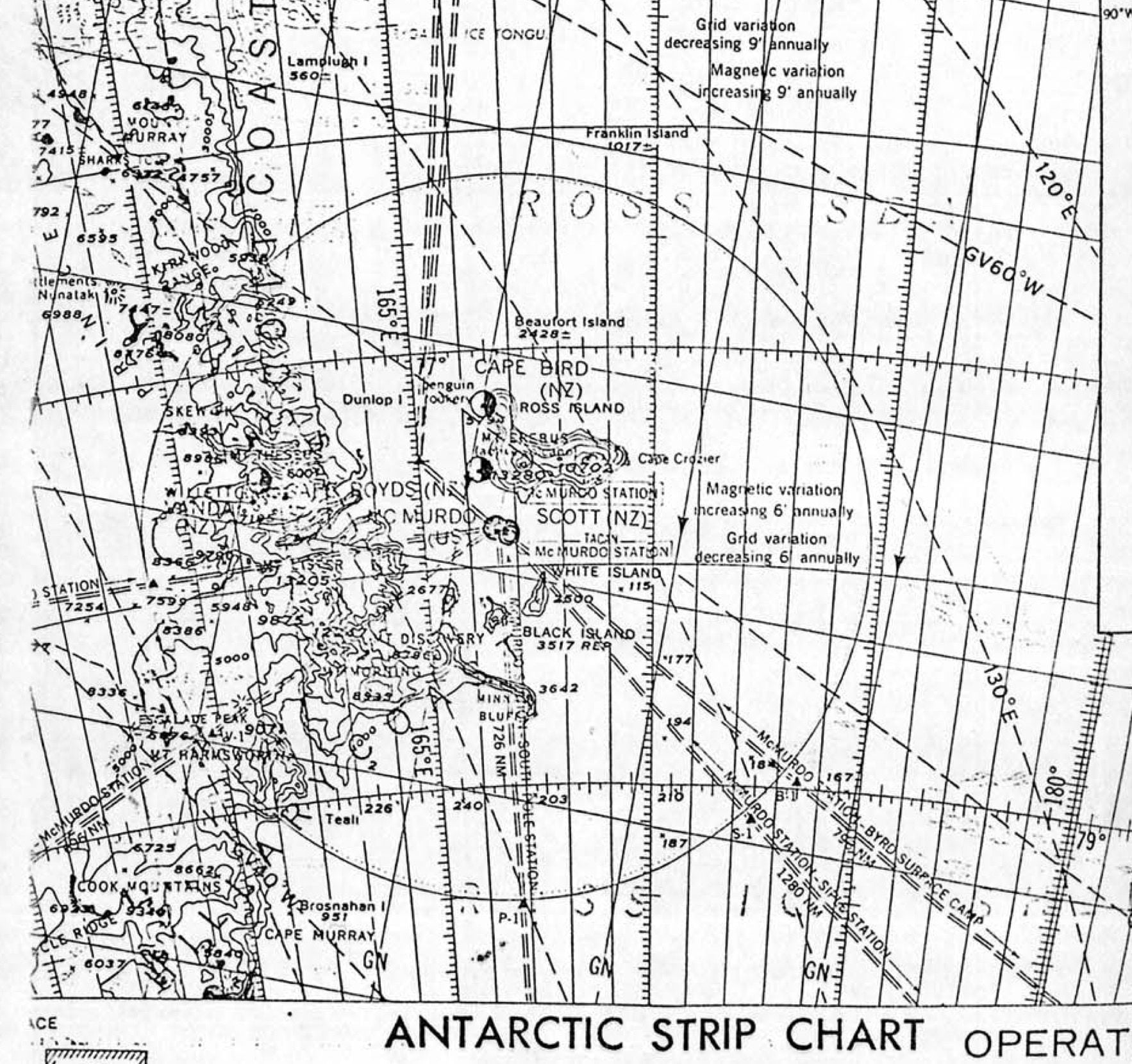
I dug out my original Antarctic Strip Chart from the back of the study as I haven't used it for a couple of months. It's a more recent edition and yes Beaufort outline there, clearly against the blue background. The chart labels are identical in the same place so it's the same map origin so I don't doubt that it was labelled on the original published chart at the time. Is there any confirmation anywhere if the recovered strip map from the accident flight was an original or a photostat? If the latter there's every chance that the island may not have been visible on the chart for navigation.
Either way, it's not really a good map for VFR nav is it? Why weren't they given better ones, if the expectation was that they were to navigate visually in VMC?
Bob Thomson .... always insisted on a complete circuit of Ross Island before letting down below 17,000ft, that way I could get an idea of the complete situation and what the weather was like, where any clouds were.
VMC weather rminma was not enough to operate safely.
Last edited by compressor stall; 3rd Dec 2019 at 05:44.

Whispering "T" Jet
There would have been no need to debate LSALT, what constitutes VMC conditions, white out, CVR recordings, FDR configurations and the plethora of other assumptions, innuendos, insinuations and orchestrated litany of lies had the crew simply been told by the Air New Zealand navigation section of the track change. Collins would have methodically plotted the new route and seen that it followed a track down Lewis Bay directly at Mt. Erebus and not the safe, flat, over sea route down McMurdo sound with Erebus well clear, miles from the aircraft flight path.
No accident, no Chippendale report, no Mahon inquiry, no nefarious behaviour by Air New Zealand management and NZ government of the day and more importantly, NO LOSS of LIFE.
Some of the participants on this forum just don't seem to grasp that fact. You can bang on all you like about Swiss cheese, advances in human factors, causal factors and the apportionment of blame. The FACT is, in this accident, the "trigger was pulled" when the route was changed and Jim Collins and his crew were not advised.
Join Date: May 2016
Location: Auckalnd
Posts: 154
Likes: 0
Received 0 Likes
on
0 Posts
There would have been no need to debate LSALT, what constitutes VMC conditions, white out, CVR recordings, FDR configurations and the plethora of other assumptions, innuendos, insinuations and orchestrated litany of lies had the crew simply been told by the Air New Zealand navigation section of the track change. Collins would have methodically plotted the new route and seen that it followed a track down Lewis Bay directly at Mt. Erebus and not the safe, flat, over sea route down McMurdo sound with Erebus well clear, miles from the aircraft flight path.
No accident, no Chippendale report, no Mahon inquiry, no nefarious behaviour by Air New Zealand management and NZ government of the day and more importantly, NO LOSS of LIFE.
Some of the participants on this forum just don't seem to grasp that fact. You can bang on all you like about Swiss cheese, advances in human factors, causal factors and the apportionment of blame. The FACT is, in this accident, the "trigger was pulled" when the route was changed and Jim Collins and his crew were not advised.
No accident, no Chippendale report, no Mahon inquiry, no nefarious behaviour by Air New Zealand management and NZ government of the day and more importantly, NO LOSS of LIFE.
Some of the participants on this forum just don't seem to grasp that fact. You can bang on all you like about Swiss cheese, advances in human factors, causal factors and the apportionment of blame. The FACT is, in this accident, the "trigger was pulled" when the route was changed and Jim Collins and his crew were not advised.
No accident, no Chippendale report, no Mahon inquiry, no nefarious behaviour by Air New Zealand management and NZ government of the day and more importantly, NO LOSS of LIFE.
Join Date: Aug 2007
Location: Auckland
Age: 52
Posts: 72
Likes: 0
Received 0 Likes
on
0 Posts
it wasn't ALL they were relying on, they were also relying on their eye-sight. Unfortunately the geographic features they could see and identify (incorrectly) were not telling them anything to contradict their opinion of their location.
Join Date: Aug 2007
Location: Auckland
Age: 52
Posts: 72
Likes: 0
Received 0 Likes
on
0 Posts
Did anything ever arise out of a letter to Justice Mahon on page 232 of Paul Holmes book? In it a passenger who claimed to be on the "first flight to Antarctica" had descended through cloud to a low altitude "When we did come out of the cloud, at about 9000 feet there was this huge mountain just off the right wing-tip". The writer had some "unspliced film" of this trip. I suspect they were mistaken in one or two areas (was it the first flight or perhaps first flight of a year, was it left or right wing-tip, how did they measure altitude etc) but was this account ever fact-checked?
Join Date: Oct 2013
Location: New Zealand
Age: 71
Posts: 1,475
Likes: 0
Received 0 Likes
on
0 Posts
Join Date: Nov 2019
Location: Paraparaumu
Posts: 0
Likes: 0
Received 0 Likes
on
0 Posts
Paragraph 377, I had a look at your public profile, which is why it is there I suppose.; It states you have an ALTP and current types are 747 and 777.
"The Crew thought they were in the right place and had no reason to believe otherwise because nobody had told them that the computer had been changed the night before."
Is that your belief as to the cause of this accident, the computer had been changed??
"The Crew thought they were in the right place and had no reason to believe otherwise because nobody had told them that the computer had been changed the night before."
Is that your belief as to the cause of this accident, the computer had been changed??