


african VFR charts

Thread Starter
Join Date: Feb 2006
Location: italy
Age: 54
Posts: 105
Likes: 0
Received 0 Likes
on
0 Posts
african VFR charts
Hi guys...I have to ferry a small twin engine from Italy to Mombasa (Kenya). This plane uses AVGASS100LL (difficult to find over there  ) and it may fly just 700 NM before refuelling. I'm having problems to plot my route coz I cant find any VFR chart. Does anybody know how I can get there and where I can find Sudan, Egypt, Ethiopia, Kenya vfr charts? The plane can only fly VFR (unfortunately) and I need to know if there is any resticted or danger zone. Thanks for your help buddies
) and it may fly just 700 NM before refuelling. I'm having problems to plot my route coz I cant find any VFR chart. Does anybody know how I can get there and where I can find Sudan, Egypt, Ethiopia, Kenya vfr charts? The plane can only fly VFR (unfortunately) and I need to know if there is any resticted or danger zone. Thanks for your help buddies

Join Date: Apr 2007
Location: Mordor
Posts: 90
Likes: 0
Received 0 Likes
on
0 Posts
You can get the vfr charts from the according aviation authorities in that country but I'll doubt they'll send them to you. Have a look at getting some military vfr charts. They are more accurate but cost a little extra.
The low enroute charts will show prohibited/restricted areas plus frequencies anyhow.
The low enroute charts will show prohibited/restricted areas plus frequencies anyhow.
Join Date: Sep 2007
Location: UAE & Africa
Posts: 89
Likes: 0
Received 0 Likes
on
0 Posts
Government printed VFR charts north of the Limpopo are almost non-existant nowadays. The only solution is to obtain ONC charts from a good pilot shop. However, much of their data is out of date by years.
Join Date: Mar 2005
Location: here, there, everywhere
Age: 47
Posts: 119
Likes: 0
Received 0 Likes
on
0 Posts
Ah, African VFR charts. Almost none around that are any use. Most of the ones we had had big white areas saying relief data unavailable. Like the maps of old, here be dragons! If u can, take a garmin 540 or similar, with the Africa updates, thats the best you will find. Good luck.

Join Date: Dec 1999
Location: UK
Posts: 2,584
Likes: 0
Received 0 Likes
on
0 Posts
You may find that Egypt requires airways flight or at least flight under airways at extraordinary minimum altitudes (FL110 rings a bell) for transit flights. Is VFR permitted at all in Egyptian airspace?
This was the case some years ago if memory serves.
I also don't think you'll be able (allowed) to fly VFR between any of the countries mentioned so airways, or beneath them will be the ony way so VFR charts become a bit redundant.
If you really do want to see what's down there try Stanfords in London for ONC/TPC/JOG(AIR) charts which should be available or orderable for all that route.
There is another thread running right now about AVGAS on that route, and the search function will reveal several previous ones. This isn't a trip to undertake without a great deal of planning and preferably advice from someone who has done it before.
You'll be outside VHF coverage for large parts of those routes. I'd consider HF essential. (at that altitude on the 4-5 hr leg Addis - Nairobi you'll be out of VHF coverage for 3-4 hrs...minimum)
Join Date: Jul 2005
Location: SoCal
Posts: 1,929
Likes: 0
Received 0 Likes
on
0 Posts
Suggest you contact one Sam Rutherford (use the search function, he normally posts in the Private Flying section). He's done that and, in fact, is just about to do it again with a small fleet of a/c. Should be able to point you in the right direction.
Be warned, however, that Egypt is amazingly costly! (I know because I was going to be involved in above mentioned flight, but - alas - cannot make it).
Be warned, however, that Egypt is amazingly costly! (I know because I was going to be involved in above mentioned flight, but - alas - cannot make it).
Bertos:
A couple of weeks ago, I ferried a small twin (turbine powered) from Canada to the Seychelles, and part of my route took me from Switzerland to Mombasa - about the same route that you are planning.
Some suggestions for you:
1) Don't attempt the trip VFR. It's too much of a headache. File IFR, even if it is a nice sunny day. That way, someone else will always be responsible for keeping you out of the 'no-go' areas.
2) Try to avoid Egypt if you can. It is very expensive, and as another forum member pointed out earlier, they tend to force you to fly the minimum enroute altitude (MEA) no matter what. Even if it is a clear blue sky and the MOCA is 2,000 feet, they won't let you fly under 11,000 feet...
3) Perhaps investigate going down the Saudi side of the Red Sea. You will need fewer overflight permits (only Saudi, instead of Sudan, Eretria, Ethiopia, etc.).
For further information, see the recent post I made here in this forum entitled New Series 400 Twin Otter at HKNW Wednesday night. There is also another related discussion of routes between the Med and Kenya at this recent post: Port Sudan and Asmara .
Michael
Originally Posted by bertos
...is the VHF radio ok ur I need a HF in the aircraft to listen to the frequencies if I manage to get there passing through Sudan?
I had a HF radio, but didn't bother using it on that sector. The HF radio was useful on the Djibouti to Nairobi sector, but I could have lived without it.
Originally Posted by Agaricus bisporus
...You'll be outside VHF coverage for large parts of those routes. I'd consider HF essential. (at that altitude on the 4-5 hr leg Addis - Nairobi you'll be out of VHF coverage for 3-4 hrs...minimum)
HF would be helpful, for sure, but I don't think I would call it 'essential'.
Michael
Bertos:
Here's a possible route for you, based on my experience a few weeks ago. You will have to do your own investigation to determine whether or not AVGAS is available at all the airports listed.
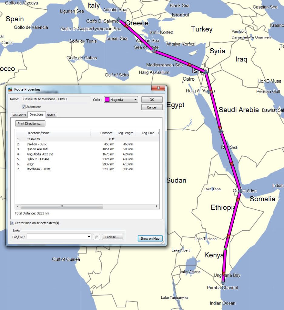
The route is pretty simple: From Brindisi, to Iraklion, to Jordan, then to Saudi, then Djibouti, then Wajir, then Mombasa.
This keeps you out of Egypt (expensive and it can be a frustrating place), and you require fewer overflight permits down the east side of the Red Sea than you would down the west side.
If the legs from Jordan to Jeddah and Jeddah to Djibouti are a bit too long for you (I had 10 knot headwinds when I flew down the Red Sea), just pick two places to land in Saudi, instead of just one.
The Saudi controllers are pretty easy to work with, a lot of them are expatriate Americans.
Hope this helps, but like I said, I have no idea what the AVGAS situation is like at any of these places, and you will have to do your own investigations about overflight permits, etc. This especially includes Wajir - I have no idea if that is an airport of entry or not, and I have no idea if they have AVGAS or not.
If Wajir has no AVGAS or is not an airport of entry, you could always go to Addis, then enter Kenya at Lokichokio (way up in the north-west corner, about where the 'e' is in the label "Lake Turkana"). I doubt that Loki has AVGAS, but I know it is an airport of entry, and you could certainly get automobile gasoline there.
I am sure other forum members who are familiar with some of these places will be able to provide additional guidance and suggestions.
Michael
A Possible Route
Here's a possible route for you, based on my experience a few weeks ago. You will have to do your own investigation to determine whether or not AVGAS is available at all the airports listed.
The route is pretty simple: From Brindisi, to Iraklion, to Jordan, then to Saudi, then Djibouti, then Wajir, then Mombasa.
This keeps you out of Egypt (expensive and it can be a frustrating place), and you require fewer overflight permits down the east side of the Red Sea than you would down the west side.
If the legs from Jordan to Jeddah and Jeddah to Djibouti are a bit too long for you (I had 10 knot headwinds when I flew down the Red Sea), just pick two places to land in Saudi, instead of just one.
The Saudi controllers are pretty easy to work with, a lot of them are expatriate Americans.
Hope this helps, but like I said, I have no idea what the AVGAS situation is like at any of these places, and you will have to do your own investigations about overflight permits, etc. This especially includes Wajir - I have no idea if that is an airport of entry or not, and I have no idea if they have AVGAS or not.
If Wajir has no AVGAS or is not an airport of entry, you could always go to Addis, then enter Kenya at Lokichokio (way up in the north-west corner, about where the 'e' is in the label "Lake Turkana"). I doubt that Loki has AVGAS, but I know it is an airport of entry, and you could certainly get automobile gasoline there.
I am sure other forum members who are familiar with some of these places will be able to provide additional guidance and suggestions.
Michael
A Possible Route

Join Date: Jul 2005
Location: SoCal
Posts: 1,929
Likes: 0
Received 0 Likes
on
0 Posts
I think V1's idea is good - except for the AVGAS. Make sure you know the situation 100% (well, whatever passes as 100% in these parts.....).
Lokichokio had AVGAS many years ago and I suspect they still do, as a lot of relief/humanitarian assistance flights into southern Sudan stage(d) through there.
One more thought about GPS - I have of course no idea of the installation in the a/c yo will fly, but if you plan on using a handheld, make sure you've got an external antenna! By which I mean an active antenna that plugs into the unit, but lives inside the cockpit under the windshield, thus having an unobstructed 'view' of the sky. Quite a few parts of Africa have rather poor satellite reception (not many satellites) and this makes all the difference! Costs a few quid/Euro/Dollars.
