


Mooney Into Powerlines Near D.C.

Thread Starter
Mooney Into Powerlines Near D.C.
MONTGOMERY VILLAGE, Md. - There are widespread power outages reported across part of Montgomery County after a small plane crashed into power lines on Sunday evening.
The incident happened around 6:15 p.m. in the area of Rothbury Drive and Goshen Road in the Montgomery Village area of Gaithersburg.
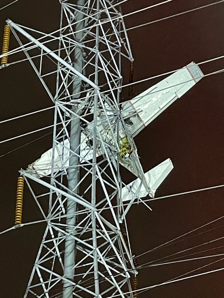
Mooney Powerline Accident
- Ed
The incident happened around 6:15 p.m. in the area of Rothbury Drive and Goshen Road in the Montgomery Village area of Gaithersburg.
Mooney Powerline Accident
- Ed
Last edited by cavuman1; 28th Nov 2022 at 01:19. Reason: Add Photo


Join Date: Dec 2016
Location: Manchester
Posts: 58
Likes: 0
Received 0 Likes
on
0 Posts
2 rescued after small plane crashes into power lines in Maryland
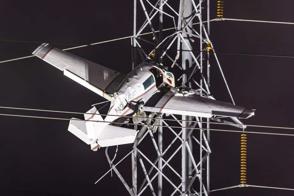
Two people have been rescued after a small plane crashed into a power line tower in Maryland, leaving the two occupants dangling about 100 feet in the air for hours. The crash knocked out power to thousands of people in the area for much of the evening.
A single-engine Mooney M20J crashed into Pepco tower lines near Montgomery County Airpark in Gaithersburg, Maryland, around 5:40 p.m. local time Sunday, according to the Federal Aviation Administration.
A single-engine Mooney M20J crashed into Pepco tower lines near Montgomery County Airpark in Gaithersburg, Maryland, around 5:40 p.m. local time Sunday, according to the Federal Aviation Administration.
Join Date: Dec 2016
Location: Manchester
Posts: 58
Likes: 0
Received 0 Likes
on
0 Posts
Regional power company (Pepco) had power restored within 8 hrs of the crash.
Given the minimal airframe damage and survival of both occupants, those lattice towers must have substantial "sproing."
Flightaware shows aircraft was on the RNAV 14 approach.
KGAI 272156Z AUTO VRB04KT 1 1/4SM BR OVC002 11/11 A2945 RMK AO2 SLP987 T01060106
Given the minimal airframe damage and survival of both occupants, those lattice towers must have substantial "sproing."
Flightaware shows aircraft was on the RNAV 14 approach.
KGAI 272156Z AUTO VRB04KT 1 1/4SM BR OVC002 11/11 A2945 RMK AO2 SLP987 T01060106

Something similar happened at Boeing Field in Seattle maybe 20 years ago. IIRC, small aircraft was doing a go-around when it landed on power lines along East Marginal Way. Pilot was uninjured but they had E Marginal shutdown for several hours while they effected the rescue.
At the time I was working at the Boeing "Thompson Site" - on East Marginal just south of where the accident occurred (I think they're currently do the P-8 modification there). Anyway it made getting to work that morning a major challenge...
At the time I was working at the Boeing "Thompson Site" - on East Marginal just south of where the accident occurred (I think they're currently do the P-8 modification there). Anyway it made getting to work that morning a major challenge...
Apparently low approach on final, perhaps in rain and fog in the dark. The occupants were in the plane for seven hours (?) while the power company grounded the wires then secured the plane to the tower before they were evacuated.
The tower took some damage.
The plane has been “segmented” and removed from the tower.
https://www.msn.com/en-us/news/us/two-rescued-after-plane-crashes-into-maryland-power-lines/vi-AA14ERpy
The tower took some damage.
The plane has been “segmented” and removed from the tower.
https://www.msn.com/en-us/news/us/two-rescued-after-plane-crashes-into-maryland-power-lines/vi-AA14ERpy
Join Date: Nov 2004
Location: Here, there, and everywhere
Posts: 1,122
Likes: 0
Received 12 Likes
on
7 Posts
Apparently low approach on final, perhaps in rain and fog in the dark. The occupants were in the plane for seven hours (?) while the power company grounded the wires then secured the plane to the tower before they were evacuated.
The tower took some damage.
The plane has been “segmented” and removed from the tower.
https://www.msn.com/en-us/news/us/two-rescued-after-plane-crashes-into-maryland-power-lines/vi-AA14ERpy
The tower took some damage.
The plane has been “segmented” and removed from the tower.
https://www.msn.com/en-us/news/us/two-rescued-after-plane-crashes-into-maryland-power-lines/vi-AA14ERpy
Link doesn't work for me BFSGrad.
He should not have been 100 feet above ground level that far out from the airport…
He was warned about the low altitude and was given an update about the altimeter reading.
High to low, look out below??
He was warned about the low altitude and was given an update about the altimeter reading.
High to low, look out below??
IFR mentioned but if the video is accurate then his IF was a bit ropey. Maybe out of practice as a PPL.
https://philip.greenspun.com/blog/20...to-powerlines/
Note: The full list of METARS aren’t showing up in what I quoted…
…The only tall high-voltage lines that I can see are about a mile from the runway, top left of the above image, rather near Giant Food. That’s quite a distance from the runway to be so low to the ground.
Let’s check the weather. 5:40 pm is 17:40 EST then add 5 hours and we get 2240Z. Here’s are the METARS:
Why isn’t there a METAR closer to 2240Z? It seems that the 2256Z observation would have come after the massive power failure. Here’s an observation from nearby Dulles Airport:
Could part of the problem be that the altimeter in the Mooney wasn’t set correctly and, therefore, the instruments were showing the plane to be higher than it was? This is an irrelevant factor for an approach with a glide path, which KGAI has. They would have gotten fresh altimeter settings during the entire flight from Air Traffic Control. The departure airport, KHPN, had an altimeter setting of 29.64″ about one hour before accident. So if they’d taken off from HPN and never touched the altimeter they would have been (29.64-29.45)*1000 = 190′ lower than indicated. This kind of mistake resulted in an accident at KBDL to American Airlines 1572(The NTSB report says that they were on a VOR 15 non-precision (no glideslope) approach.)
The weather was not improving dramatically after 2156Z (4:56 pm). Is it reasonable to land with only 1.25 miles of visibility and 200′ overcast? If you’re a two-pilot crew going into Dulles Airport with its idiot-proof runways and powerful approach lighting system that will cut through the clouds and mist… yes. In fact, the minimums for the ILS 1R at KIAD are 200′ ceiling and 1800′ of visibility.
What about at KGAI? Assuming that this airplane was trying to land, they’d be using the RNAV 14. With the latest and greatest WAAS-capable avionics, the weather minimums are 269′ and 1 mile of visibility. Touchdown zone elevation is 520:
[etc.]
Let’s check the weather. 5:40 pm is 17:40 EST then add 5 hours and we get 2240Z. Here’s are the METARS:
Code:
KGAI 272156Z AUTO VRB04KT 1 1/4SM BR OVC002 11/11 A2945 RMK AO2 SLP987 T01060106
KGAI 272128Z AUTO 18003KT 1 1/4SM BR OVC002 11/11 A2945 RMK AO2
KGAI 272121Z AUTO 14006KT 3/4SM BR OVC002 10/10 A2945 RMK AO2
KGAI 272110Z AUTO 14007KT 1 1/4SM BR OVC002 11/10 A2946 RMK AO2
KGAI 272056Z AUTO 15004KT 2SM BR OVC002 11/10 A2947 RMK AO2 PRESFR SLP995 60003 T01060100 56050
Code:
KIAD 272252Z 21011KT 1 1/2SM BR OVC003 11/11 A2945 RMK AO2 SFC VIS 9 SLP971 T01110106
The weather was not improving dramatically after 2156Z (4:56 pm). Is it reasonable to land with only 1.25 miles of visibility and 200′ overcast? If you’re a two-pilot crew going into Dulles Airport with its idiot-proof runways and powerful approach lighting system that will cut through the clouds and mist… yes. In fact, the minimums for the ILS 1R at KIAD are 200′ ceiling and 1800′ of visibility.
What about at KGAI? Assuming that this airplane was trying to land, they’d be using the RNAV 14. With the latest and greatest WAAS-capable avionics, the weather minimums are 269′ and 1 mile of visibility. Touchdown zone elevation is 520:
[etc.]
https://wtop.com/montgomery-county/2...g-plane-crash/
https://wtop.com/wp-content/uploads/...2_45_33-AM.pdf
NTSB Preliminary Accident Report
https://wtop.com/wp-content/uploads/...2_45_33-AM.pdf
NTSB Preliminary Accident Report
…Dark night instrument meteorological conditions prevailed in the area of GAI at the time of the accident. The reported weather at GAI included variable wind at 4 knots, an overcast ceiling at 200 ft above ground level (agl), and 1.25 statute miles visibility in fog. A convective SIGMET was valid for the accident time.
Preliminary Federal Aviation Administration (FAA) air traffic control communication information revealed that the pilot was advised to expect the RNAV/GPS A instrument approach procedure at GAI, but the pilot expressed a preference for the RNAV (GPS) RWY 14 approach procedure. The controller cleared the pilot to fly directly to the BEGKA intermediate fix (IF), approximately southwest and ahead of the airplane’s position, but instead, the airplane turned about 100� to its right. The controller provided numerous heading changes and direct clearances to waypoints on the RNAV (GPS) RWY 14 approach procedure; however, the pilot made a series of left and right turns, near course reversals, or continued established headings as the controller repeatedly requested that the pilot turn to a different heading. At one point, the controller requested that the pilot confirm he had the BEGKA waypoint and spelled it for him. The pilot responded that he had entered the information incorrectly and was making the correction. About that time, another airplane on approach to GAI announced that visibility was below minima and requested a diversion to another airport.
The controller instructed the accident pilot to proceed direct to BEGKA and cleared him for the RNAV (GPS) RWY 14 approach. The minimum altitude at BEGKA, 11.3 nautical miles (nm) from the runway, was 3,000 ft mean sea level (msl). The airplane crossed BEGKA about 2,775 ft as it aligned with the final approach course and continued its descent. The minimum altitude at the final approach fix (TIMBE), 5.2 nm from the runway, was 2,200 ft msl. The airplane crossed TIMBE at 1,725 ft msl. The minimum altitude at JOXOX waypoint, about 2.3 nm from the runway, was 1,280 ft msl; the airplane crossed JOXOX at 750 ft. The decision altitude (DA) for the final segment of the approach was 789 ft msl (The DA defines the altitude at which the pilot must initiate a missed approach procedure if specified visual references to the runway are not acquired).
About 1.25 miles from the runway and left of the runway centerline, the airplane impacted and became suspended in a power line tower at an elevation about 600 ft msl and 100 ft agl. Between JOXOX and the collision with the tower, the airplane descended as low as 475 ft. The published field elevation at GAI was 539 ft msl.
Figure 1 shows preliminary flight track information in relation to the runway 14 final approach course, with minimum altitudes for each segment of the approach shown in orange, and the airplane’s altitude at those locations shown in white.…