


Plane down Overbury, Tewkesbury.

Join Date: Jul 2003
Location: uk
Posts: 1,041
Likes: 0
Received 0 Likes
on
0 Posts
Reason i say it cartwheeled is that the nose is offset, rear fuselage is buckled, wings off and one side tail plane is missing.
This accident reminds me of the one round here in the nineties. Mooney pilot enroute from south to Sleap, called asking what the cloud base was, told it was about 1300 feet.
I was 1100 just returning to HG airfield. Controller later asked what frequency did the Mooney change to, no one knew.
Later we found out had descended and hit the Wrekin hill, tops 1400 feet, 30 feet from it's top. Local pilots know of it, but for someone unfamillier with the area, hard to see on a map. Looks like a Volcano.
Last edited by BigEndBob; 24th Jan 2018 at 10:26.

The ???? was because of this comment "The end impact was a result of loss of control."
If it was CFIT then "The end impact was a result of hitting something on the ground a few seconds earlier."
...and likewise, sports metaphors (especially American ones) are lost on me too.
...BigEndBob. Every UK military controller is aware of the Wrekin and its sister peak adjacent to RAF Cottam ;-)
Join Date: Nov 2012
Location: UK
Posts: 25
Likes: 0
Received 0 Likes
on
0 Posts
SWB - aha I see your objection. IF (I'm still not convinced but am not ruling it out) it hit/clipped the trees then whatever else occurred it is still CFIT. The sentence you quote above is my attempt to point out that it did not just hit the trees and then continue out of control to end up where it hit the dirt but must have climbed (this could have been in or out of control) after said theoretical tree contact, high enough to then come down vertically (or at least with large vertical component) in the field. I was simply trying to point out the distinction as most seem to be suggesting it hit the trees and continued in more or less the same trajectory until stopping where it is shown in the media images. I argue that the wreckage and positioning make this scenario impossible.
I would argue (and folks are welcome to disagree) that an aircraft 'forced' to lose height is no longer under control. Yes you could still have control of the flight axis but you do not have control of the engine and therefore the descent is not a controlled but a forced manoeuvre. I would call such an accident 'forced landing in IMC resulting in collision with unseen terrain'.
I would argue (and folks are welcome to disagree) that an aircraft 'forced' to lose height is no longer under control. Yes you could still have control of the flight axis but you do not have control of the engine and therefore the descent is not a controlled but a forced manoeuvre. I would call such an accident 'forced landing in IMC resulting in collision with unseen terrain'.

Join Date: Oct 1999
Location: UK
Posts: 3,325
Likes: 0
Received 0 Likes
on
0 Posts
If the first deviation from a controlled and intended flightpath was hitting trees, it was CFIT. Anything that subsequently happened (and in my book all that in all probability subsequently happened was, seriously damaged, it hit the ground beyond the trees) is not the cause of the accident.
If it didn't hit the trees but a 'close encounter' led to a sudden climb and loss of control in IMC, then it wasn't CFIT.
If it didn't hit the trees but a 'close encounter' led to a sudden climb and loss of control in IMC, then it wasn't CFIT.
Last edited by Shaggy Sheep Driver; 25th Jan 2018 at 07:07.
Join Date: Jul 2003
Location: uk
Posts: 1,041
Likes: 0
Received 0 Likes
on
0 Posts
The ???? was because of this comment "The end impact was a result of loss of control."
If it was CFIT then "The end impact was a result of hitting something on the ground a few seconds earlier."
...and likewise, sports metaphors (especially American ones) are lost on me too.
...BigEndBob. Every UK military controller is aware of the Wrekin and its sister peak adjacent to RAF Cottam ;-)
If it was CFIT then "The end impact was a result of hitting something on the ground a few seconds earlier."
...and likewise, sports metaphors (especially American ones) are lost on me too.
...BigEndBob. Every UK military controller is aware of the Wrekin and its sister peak adjacent to RAF Cottam ;-)
Join Date: Jan 2017
Location: Warwick
Posts: 197
Likes: 0
Received 0 Likes
on
0 Posts
I doubt they had time to communicate the instant of the terrain encounter, a likely scenario is they were merrily scud running probably with the student flying, saw the trees, pulled up, clipped the trees and stalled. That would easily account for the plane being a little way from the trees.
They might have had engine problems but it was very bad luck at that critical point in a flight lasting maybe 30 mins or more.
They might have had engine problems but it was very bad luck at that critical point in a flight lasting maybe 30 mins or more.
Join Date: Nov 2012
Location: UK
Posts: 25
Likes: 0
Received 0 Likes
on
0 Posts
I know a guy who knows the estate workers who were first on the scene. So this is 3rd hand and not a statement of fact but more of rumor. They say it DID hit the trees first so it would seem it was CFIT after all... I still hold that the impact was mostly vertical so the aircraft has to have climbed at least 100ft after hitting the trees (and I know SSD categorically disagrees with this and i respect his take on it! We are agreeing to disagree!) in order to come down the way it has in the field but I have bored everyone with that too much already.
I looked up the 'quarterback' phrase on Google and this is what it told me:
Monday morning quarterback. a person who criticizes the actions or decisions of others after the fact, using hindsight to assess situations and specify alternative solutions.
I was a bit put out initially (and I suspect it wasn't meant as a compliment in this case) but then I thought - too right! We are a small band us aviators and if we are not looking to assess what goes wrong and 'specify alternative solutions' then we are arrogant and ignorant and likely to end up in a mess sooner or later. This is precisely why the AAIB look into these things! In 'sport' I can see how this phrase is meant in a negative light but when it is life or death we all want to help each other to fly again another day and should all be looking to better our skills/knowledge/understanding as a large part of our aviation ethos/mindset. Personally I welcome people seeking to do things better than me and not repeating the mistakes I make!
I am taking particular interest in this case as the collision was 4.4miles from the airfield I fly and run my business from, in an aircraft I have a couple of variants of in my business and they were flying to and from airfields I regularly do too. This couldn't be more 'on my doorstep'. I do not seek to 'criticize' but to understand and learn from this tragedy and do my utmost to ensure it never happens to me, my passengers or anyone else I know and/or fly with.
The 'hindsight' in the phrase definition gets my hackles up though! We have another name for 'hindsight' in aviation and it is called 'airmanship'. If this was CFIT then avoiding it wasn't hindsight - it was airmanship. It reminds me of when our 152 was landed here once with a 15kt tailwind straight up the 575meter grass runway. It didn't touchdown until gone halfway and the end result was a predictable off runway excursion with prop strike and bent wingtip. When I got to the other end to talk to the pilot (it was being dropped in for maintenance) I asked him in no-uncertain terms why the fruit he had decided to land with a 15kt tailwind. His response was 'its all very well saying that now with hindsight'!!! HINDSIGHT? said I (yes, probably yelling by this point) - THERE IS A WINDSOCK RIGHT THERE!!!! ITS CALLED AIRMANSHIP NOT HINDSIGHT! In this developed age of light aviation what causes accidents is nearly never hindsight but foresight that is lacking. So other than 'criticize' and 'hindsight', I'm happy to wear the 'Monday Morning Quarterback' phrase!
https://www.gov.uk/aaib-reports/aaib...ior-iii-g-wavs
AAIB report now published.
AAIB report now published.
Conclusion
The aircraft struck trees near the summit of Bredon Hill following flight into conditions of deteriorating visibility. The aircraft was not equipped to operate in the icing conditions forecast in cloud and so could not climb to the minimum safe altitude.
In visibility close to the limits permitted under VFR there is very little time to avoid terrain and obstacles that may be encountered and, should conditions deteriorate, flight in these circumstances presents few options for a safe outcome.
CAP 1535, published by the CAA, advises pilots that flight in the minimum conditions of cloud and visibility permitted under VFR is not necessarily safe, and describes steps that can be taken when planning the flight to mitigating the risks of flight into terrain in poor weather.
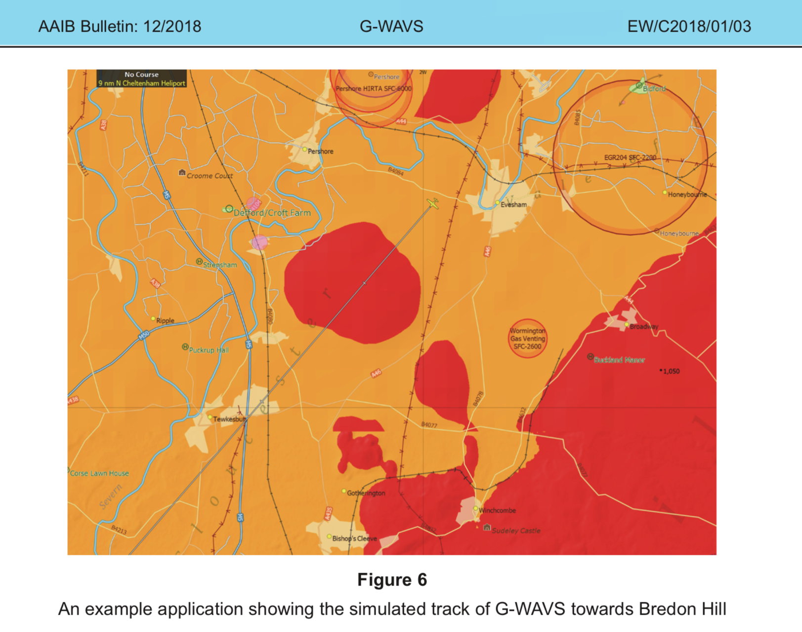
The image shows the rising ground of Bredon Hill relative to the simulated aircraft flying at 900 ft amsl, and high ground to the right side of the Figure.
Civil Air Publication (CAP) 1535, ‘The Skyway Code’, published by the CAA, states:
The instructor was not known to use GPS navigation or flight planning software and did not carry a tablet or smart phone that could employ such systems. There is no requirement to do so.
Witnesses from the school stated that they had been taught that when lost they should circle a recognisable feature and then contact the Distress and Diversion cell at NATS Swanwick (D&D) on 121.5 MHz.
Join Date: Dec 2014
Location: LHBS
Posts: 281
Likes: 0
Received 0 Likes
on
0 Posts
Oh, crap...  right into the middle of that hill.
This leaves so little chance to make a quick turn to the left or right.
Looks like following those rivers would have been safer (less likely to hit terrain)
right into the middle of that hill. This leaves so little chance to make a quick turn to the left or right.
Looks like following those rivers would have been safer (less likely to hit terrain)
Join Date: Jan 2008
Location: UK
Posts: 1,464
Likes: 0
Received 0 Likes
on
0 Posts
The pilot was heard to express some concerns about the weather and appeared anxious to start the trip as soon as possible.
The forecast and actual weather reports for the Coventry area showed light winds from the north-east with a cloud base of approximately 1,000 ft. The Gloucester weather for the period of the accident also showed a light north-easterly wind with visibility reducing to 3,500 m in drizzle and mist and a cloud base of approximately 600 ft.
The instructor was not known to use GPS navigation or flight planning software and did not carry a tablet or smart phone that could employ such systems. There is no requirement to do so.
Huge holes in the cheese lining up here.
Join Date: Aug 2009
Location: Qwerty
Posts: 380
Likes: 0
Received 0 Likes
on
0 Posts
Should have told his employer he was not playing that day.
Experienced enough to have said no.
I think I would have taken the climb above MSA and risked a touch of ice rather than hitting a hill and a May Day for vectors to the nearest suitable strip of Tarmac, probably Gloucester being routed down the middle of the Severn Valley.
Experienced enough to have said no.
I think I would have taken the climb above MSA and risked a touch of ice rather than hitting a hill and a May Day for vectors to the nearest suitable strip of Tarmac, probably Gloucester being routed down the middle of the Severn Valley.
Last edited by Council Van; 9th Dec 2018 at 12:42.
Join Date: Aug 2008
Location: UK
Posts: 3
Likes: 0
Received 0 Likes
on
0 Posts
Join Date: Dec 2014
Location: Uk
Posts: 4
Likes: 0
Received 0 Likes
on
0 Posts
A massive shame.
seemed he wasn’t happy with the conditions before even going......just say no !
had a few close calls as an instructor , hopefully I’m older , wiser and more aware of my own mortality now.
every year , there’s a few CFITs in the winter.
seemed he wasn’t happy with the conditions before even going......just say no !
had a few close calls as an instructor , hopefully I’m older , wiser and more aware of my own mortality now.
every year , there’s a few CFITs in the winter.
Can’t help wondering why, with the reported conditions, they didn’t just head west from Evesham to pick up the M5, and then follow it South. If the instructor was familiar with the area that would seem logical, rather than continuing towards Bredon hill.
I was just catching up on this thread and BigEndBob's post caught my eye:
In the late 60s, I was on a dual Chipmunk flight southeast of Shawbury, above a stratus layer. My instructor didn't want to wait for the AH to re-erect after some aerobatics, so he told me to descend through a very narrow hole in the cloud, with some green fields just visible below. When we reached cloud base, I was surprised to see we were directly over the top of the Wrekin, although safely above it. My instructor told me that it was a well known phenomenon - even a light wind blowing over the Shropshire Plain would lift the airmass over the Wrekin and cause local dissipation of the cloud. I hasten to add that this is not a trick I would recommend if the cloud base is below the hill tops.
This anecdote brings back one of the joys of RAF Chipmunk flying in the winter. We could take off on a typical, miserable winter's day with limited visibility and low cloud base, climb through a stratus layer, picking up a bit of ice on the way and then break out into blue sky, with the sun shining and a white cloud deck stretching as far as you could see. The instructors didn't like it so much, because the back seat was very drafty and cold as I discovered when doing instrument flying from the back seat.
Later we found out had descended and hit the Wrekin hill, tops 1400 feet, 30 feet from it's top. Local pilots know of it, but for someone unfamillier with the area, hard to see on a map. Looks like a Volcano.
This anecdote brings back one of the joys of RAF Chipmunk flying in the winter. We could take off on a typical, miserable winter's day with limited visibility and low cloud base, climb through a stratus layer, picking up a bit of ice on the way and then break out into blue sky, with the sun shining and a white cloud deck stretching as far as you could see. The instructors didn't like it so much, because the back seat was very drafty and cold as I discovered when doing instrument flying from the back seat.
Yes this one.... no outrage here at the loss of the innocent student... perhaps he needed to be a footballer and then we could discuss the ratings of pilot and fitness to fly and who was paying for what before legal consequences and who takes legal action against who..

