


Mountain ridge crossing - safety review?

Thread Starter
Join Date: Dec 2014
Location: LHBS
Posts: 281
Likes: 0
Received 0 Likes
on
0 Posts
Mountain ridge crossing - safety review?
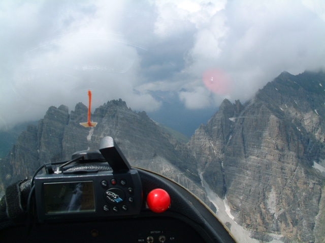
Hi, if there is anyone,who flew over mountain passes and ridge lines at or above 2000 meters/6500 feet, I would appreciate having a look at my recent flight, which went differently than planned. Was that a close call, or just normal thing to expect in mountains? It was an awsome sight and I don't think safety was compromised, but the gap between the cloud base and the ridge was a bit too little for comfort, at least for a first-timer in that environment.
Events started to unfold at 5 minutes on the video, and I was on the other side by the 8th minute, so those 3 minutes are interesting.
https://youtu.be/UY-fumzZ_wY?t=5m0s
Events started to unfold at 5 minutes on the video, and I was on the other side by the 8th minute, so those 3 minutes are interesting.
https://youtu.be/UY-fumzZ_wY?t=5m0s

All my flying near cloud is at lower level ridges in Scotland, and my higher altitude ridge crossings in US were cloud-free.
I take it you knew which side the downdrafts would be on.
I take it you were prepared for steep descending 180 turn.
You could see what you were flying into. It's your choice how confident you are in the cloud forming and downdraft predictions.
But I'd never take my attention off what's happening around me to take photos in that sort of situation. And I'd like to fly around near the ridge before going that close, to confirm wind effects.
Join Date: Nov 2000
Location: Cambridge, England, EU
Posts: 3,443
Likes: 0
Received 1 Like
on
1 Post
That looked to me far too much like risking flying in cloud below MSA - there's no way I would have been there (would have chickened out long since or been at MSA, which I take to be 2,000', not 1,000', in mountains). Still, we all have different attitudes to risk, it would be boring if we were all the same.
Thread Starter
Join Date: Dec 2014
Location: LHBS
Posts: 281
Likes: 0
Received 0 Likes
on
0 Posts
Well, I have to confess, having a favourable forecast of only light 5 kts winds and none to few clouds at 8000 feet, I planned to cross at 7500 feet, 1000 feet safely above the ridge, where this wouldn't have posed a big risk. When the cloudiness that greeted me was different from forecast, at that point all I knew I had a tailwind (and this explains the cloud formation on the south side, where I was approaching from, and the fewer clouds on the other side). However, I definitely noticed the smooth ride towards the ridge, so I instintively prepared for the turbulence and downdraft after crossing, which was still pretty violent. Makes me think about how it is in case of moderate to strong winds....
Actually the plan was for a 180 level turn at 45 degrees bank, on instruments, and then a straight descent out of the cloud, if I get into one. But this I delayed until losing sight of the ridge, which didn't happen.
Yes, I hear you, it looks annoying on the recording, even to me! Loose object in the cocpit etc. My only excuse that my attention wasn't divided much, as the picture shots were made without looking into the finder or anything at the camera in fact. Just "blind" shots at whatever the camera can see and capture in automatic mode.
Good point, many thanks.
I take it you were prepared for steep descending 180 turn.
You could see what you were flying into. It's your choice how confident you are in the cloud forming and downdraft predictions.
You could see what you were flying into. It's your choice how confident you are in the cloud forming and downdraft predictions.
But I'd never take my attention off what's happening around me to take photos in that sort of situation.
And I'd like to fly around near the ridge before going that close, to confirm wind effects.
Join Date: Jul 2012
Location: Scotland
Posts: 158
Likes: 0
Received 0 Likes
on
0 Posts
OK, it was a bit tight scudrunning but from your replies to Maoraigh1 it seems you were sufficiently aware of the potential for disaster, downdraft and turbulence on the lee side.
The point I think Maoraigh1 was making about a descending turn is that you were right in the cloudbase and that by descending you would have much better visibility to see any hard bits you would not want to hit. Your idea of a level turn on instruments gives me the chills and in all such cases I would opt for good sight of the ground features over just about everything else.
In case there was confusion over Maoraigh1's description of a "steep descending 180", I think he meant a steep 180 but descending, not steeply descending.
Last edited by DeltaV; 28th Aug 2016 at 09:46.
Thread Starter
Join Date: Dec 2014
Location: LHBS
Posts: 281
Likes: 0
Received 0 Likes
on
0 Posts
I was afraid of mentioning the dreaded word of "scud running" (#1 VFR pilot killer), but a little bit of that it indeed was.
In principle I agree, in this case however literally everthing is way too hard to hit at the mountain tops (no soft spots at all), and I made myself familiar with the terrain before crossing, so all the hard bits were to the north of me ahead, nothing behind to the south, so I felt in this specific situation a level turn is less dangerous than a descending one. You can see how reluctant I was giving away altitude when approaching the ridge, as I rather manouvered horizontally to avoid clouds in my way, in order the keep my altitude "reserve" over the ridge.
Thanks, I misunderstood that a little bit too.  Approching the crossing, I made a mental note of not overbanking the aircraft in case I hit a solid wite-out IMC cloud. I was afraid of G-stalling it with a too steep turn, which is also a bad bad thing in clouds by a VFR guy.
The point I think Maoraigh1 was making about a descending turn is that you were right in the cloudbase and that by descending you would have much better visibility to see any hard bits you would not want to hit. Your idea of a level turn on instruments gives me the chills and in all such cases I would opt for good sight of the ground features over just about everything else.
In case there was confusion over Maoraigh1's description of a "steep descending 180", I think he meant a steep 180 but descending, not steeply descending.
Approching the crossing, I made a mental note of not overbanking the aircraft in case I hit a solid wite-out IMC cloud. I was afraid of G-stalling it with a too steep turn, which is also a bad bad thing in clouds by a VFR guy.
Up to and directly above the first ridge you were benefitting from an upslope wind.
After crossing the spur ridge you dumped yourself into the nasty stuff downwind of the ridge crest.
Perhaps you could have stayed on the good side of the spur ridge and turned back on course when over lower ground.
Talk to the local glider pilots.
Overflying the cumulus can also work if you know the clouds thin out over lower ground.

It didn�t raise my eyebrows watching as there were always options. Personally I might have gone in a fraction lower to give myself better forward visibility and reduced the likelihood of flying into cloud. After all, if the cloud�s below the ridge line you�re not going through low-level anyway.
Another thing to watch is cables, antennas and that kind of thing. Not always marked on the chart and can suddenly appear out of the gloom if you�re in the cone of poor vis around cloud base.
Here�s one from a few years back, just fitted through the gap and no engine either!
Another thing to watch is cables, antennas and that kind of thing. Not always marked on the chart and can suddenly appear out of the gloom if you�re in the cone of poor vis around cloud base.
Here�s one from a few years back, just fitted through the gap and no engine either!
Join Date: Jan 2009
Location: Oxford, UK
Posts: 1,546
Likes: 0
Received 0 Likes
on
0 Posts
Lovely picture, full wings! you are braver than I, or you knew the territory very well indeed.
Although I have flown from time to time in mountains, always had a bit more margin. In the Alps, no matter how close you fly to the mountain to get the best lift, coming round the corner there was always a French glider even closer to the rocks!
And going up the valleys - we flatlanders were thoroughly briefed before heading that way, where we could find landable fields.
One flatlander was following another glider flying into a deep deep valley, every minute becoming more interesting, but expecting the French glider would know the territory and so following him he would be safe. About then, the French glider deployed his engine (which had been stowed in the fuselage) and climbed away....
Join Date: Jan 2009
Location: Oxford, UK
Posts: 1,546
Likes: 0
Received 0 Likes
on
0 Posts
rnzoli, I have now taken the trouble to look at your video. The only thing I can say is you are lucky to be alive. Don't ever take innocent passengers along on that sort of suicide flying!
Is it your aircraft? does the owner know you scrape mountainsides in IFR? Grow up!
Is it your aircraft? does the owner know you scrape mountainsides in IFR? Grow up!
Last edited by mary meagher; 28th Aug 2016 at 19:01.
Thread Starter
Join Date: Dec 2014
Location: LHBS
Posts: 281
Likes: 0
Received 0 Likes
on
0 Posts
Overflying the cumulus can also work if you know the clouds thin out over lower ground.
Thread Starter
Join Date: Dec 2014
Location: LHBS
Posts: 281
Likes: 0
Received 0 Likes
on
0 Posts
Oh, this is so true... Many of these area can be planted full of transceiver towers, masts. Normally lit by red navigation obstacle lights, but still better to see them clearly in advance. Now I start to wonder if it would have been better to reconfigure the aircraft for a slower flight, increase RPM and in exchange, go a bit lower to see better. More time to look, more time to decide, better climb rate with the advance of the throttle, tighter 180 if needed, and less prone to turbulence on the downwind side...
Join Date: Jul 2008
Location: BC, Canada
Posts: 88
Likes: 0
Received 0 Likes
on
0 Posts
rnzoli,
This video might not have raised FullWings' eyebrows, but it certainly got my attention!
Although I'm a helicopter pilot, basic mountain flying technique holds true regardless of the machine you're flying so hopefully you don't mind some feedback from a rotary wing driver who spends his time in the mountains of western Canada.
When approaching a ridge line like this, I'd always recommend losing altitude to below the ceiling/cloud bases well before reaching the mountain - you improve forward visibility and avoid avoid entering cloud like you did approaching the mountain side. It's hard to know what the clouds are doing behind the 'wispy' parts you were scud running - as it happens on this occasion they disappated but they could have equally worsened and I suspect this would have then have had a different outcome.
In questionable visibility you should fly an approach other than 90 degrees to the ridge line - typically 45 degrees is advocated. Flying offset/parallel to the ridge gives a number of advantages: you have time to look at the topography of the ridge, you can better judge visibility, you can 'feel' the wind and you have a shorter turning circle to carry out if you don't like what you see or there is an emergency. I'm not sure what your IAS was but even at a modest 100mph you don't have too long to make decisions and action them when flying directly at cloud +/- mountain.
In this case there was a clearer bright area with lower ground to your right - this would have been my choice of area to attempt a crossing, especially as there was falling ground to use as an escape route. Always leave yourself an 'out' for as long as possible and only commit to the crossing when you're sure that what lies beyond the ridge is VFR.
As RatherBeFlying mentioned the wind was upslope as you approached and you got on the 'backside' after crossing - in stronger wind conditions you can expect rotor action and down drafts after crossing the demarcation line, so you'd be wise to increase your crossing altitude if the cloud base allows for it. I'd also be cautious about relying on forecast wind speeds around mountains - they often generate their own unique weather and winds can be significantly stronger (or lighter) than anticipated.
Join Date: Feb 2005
Location: UK
Age: 85
Posts: 697
Likes: 0
Received 0 Likes
on
0 Posts
As I can bear witness from flying in Snowdonia, there is another hazard waitimg for you and that is sometimes ferocios down draughes around mountains which can catch you unawares.
And Im not just being a killjoy.
And Im not just being a killjoy.
Thread Starter
Join Date: Dec 2014
Location: LHBS
Posts: 281
Likes: 0
Received 0 Likes
on
0 Posts
When approaching a ridge line like this, I'd always recommend losing altitude to below the ceiling/cloud bases well before reaching the mountain - you improve forward visibility and avoid avoid entering cloud like you did approaching the mountain side.
questionable visibility you should fly an approach other than 90 degrees to the ridge line - typically 45 degrees is advocated.
In this case there was a clearer bright area with lower ground to your right - this would have been my choice of area to attempt a crossing, especially as there was falling ground to use as an escape route.
As RatherBeFlying mentioned the wind was upslope as you approached and you got on the 'backside' after crossing - in stronger wind conditions you can expect rotor action and down drafts after crossing the demarcation line, so you'd be wise to increase your crossing altitude if the cloud base allows for it.
Join Date: Jan 2009
Location: Oxford, UK
Posts: 1,546
Likes: 0
Received 0 Likes
on
0 Posts
helisdw, I am well impressed by your excellent summary of safe mountain flying! And in helicopters! your advice is exactly the same as we learned when flying gliders in the Alps and in Spain. You might enjoy sometime having a go in that challenging environment without an engine! I believe gliders can be found in Canada, as well as Europe, or New Zealand, with wise instructors available. Experience counts a lot in that environment.
Actually the plan was for a 180 level turn at 45 degrees bank, on instruments, and then a straight descent out of the cloud
There are old pilots and there are bold pilots, but ..........
Overflying the cumulus can also work if you know the clouds thin out over lower ground.
This actually crossed my mind briefly, but I didn't know what was waiting on the other side, and I was afraid of getting stuck above the clouds. Of course later I realized the clouds were generated by the updraft on the upwind side, so subsequently fewer clouds were on the other side. Next time I'll be wiser
This actually crossed my mind briefly, but I didn't know what was waiting on the other side, and I was afraid of getting stuck above the clouds. Of course later I realized the clouds were generated by the updraft on the upwind side, so subsequently fewer clouds were on the other side. Next time I'll be wiser
You need to learn local weather patterns and fly when the weather is in your favor.
Overflying cloud you do need fuel to turn back to good weather if you can't find a way down. Just be very sure it won't close in behind

If you seriously screw up the drill is to get over low ground and high ceilings before thinking of a descent. ATC needs to know. If all goes well, the paperwork will be waiting
