


Grand Cayman LNAV/VNAV approach?

Thread Starter
Grand Cayman LNAV/VNAV approach?
Greetings All
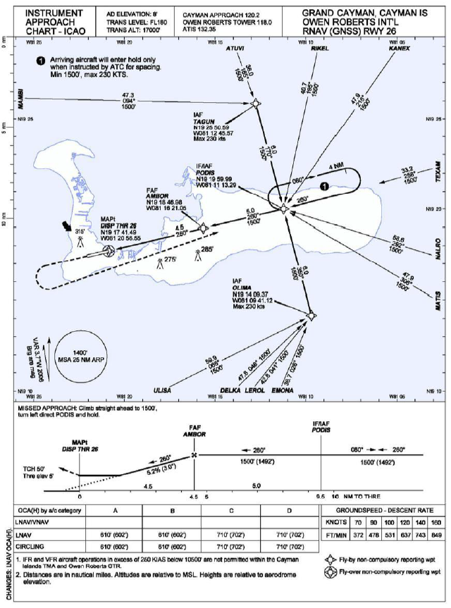
As an escapee from Rotorheads, I’m hoping that someone might be able to explain the following from the RNAV (GNSS) RWY 26 and RNAV (GNSS) RWY 08 at Grand Cayman, Owen Roberts International.
I was carrying out proficiency checks with an EC145T2 helicopter equipped with 2 Garmin 750 FMS (although very capable, I think calling them an FMS might be a little over the top!)
When the Garmin sees an LNAV approach it offers LNAV +V which provides an internally generated pseudo-glideslope (my terminology) using GPS to give a vertical deviation indicator as advisory information, the EC145 will not couple to this indication.
When the Garmin sees an LNAV/VNAV approach (which is designed to be flown using a barometric feed to the FMS), provided SBAS is available, the Garmin will fly a fully coupled 3-D approach based solely on GNSS/SBAS with no Baro input (this is perfectly acceptable).
On the 08 approach, the Garmin behaves exactly as I would expect and provides an LNAV +V; however, on 26 (which is hardly ever used as westerly winds only blow on one Thursday in March each year!) the Garmin provides a full LNAV/VNAV but there is no information on the approach plate to suggest that this approach was ever designed as LNAV/VNAV.
I’d be interested to know whether other FMS see this as an LNAV/VNAV
Cheers
TeeS

ICAO recommend that the ARINC 424 database coding is published on the reverse of the approach plates. The database houses do not encourage this practice as it inhibits their ability to 'customise' the database for individual customers i.e. the avionics manufacturers. The manufacturers themselves may then 'customise' the database coding to suit the functionality of their equipment.
I presume the Garmin procedure for RWY26 still uses the LNAV OCA, so there shouldn't be a safety issue. As you have intimated, other equipment may display coding differences.
I presume the Garmin procedure for RWY26 still uses the LNAV OCA, so there shouldn't be a safety issue. As you have intimated, other equipment may display coding differences.
