


TERRAIN database


Join Date: Sep 2010
Location: earth
Posts: 1,341
Likes: 0
Received 0 Likes
on
0 Posts
In my experience terrain DB's are global, if you are current you are good. To add to this (logically) most updates are probably more structural with the exception of geographical shifting of land mass which is minute.
Forgive my ignorance if so but your venture seems to be less grand than I assume.
Forgive my ignorance if so but your venture seems to be less grand than I assume.
Join Date: Aug 1998
Location: australia
Posts: 320
Likes: 0
Received 0 Likes
on
0 Posts
1-EGPWS database check. 737-3/4/500
EGPWS database check:
-Radar selector to TEST
-Radar button ON (pedestal)
-push TERR button ON (forward panel)
-GroundProximityWarning Test press and hold
-wait and see your EHSI screen, there will be "TDB477" (Terrain Data Base 477)
might be good for the NG never tried only on the efis classics!
EGPWS database check:
-Radar selector to TEST
-Radar button ON (pedestal)
-push TERR button ON (forward panel)
-GroundProximityWarning Test press and hold
-wait and see your EHSI screen, there will be "TDB477" (Terrain Data Base 477)
might be good for the NG never tried only on the efis classics!
Join Date: Dec 2004
Location: italy
Posts: 212
Likes: 0
Received 0 Likes
on
0 Posts
terrain databases are updated with new airport data every 3/4 months according to MK model (honeywell vendor), to be sure the airport is in the database you need to know the cycle revision your database is updated.
Join Date: Sep 2010
Location: earth
Posts: 1,341
Likes: 0
Received 0 Likes
on
0 Posts
-wait and see your EHSI screen, there will be "TDB477" (Terrain Data Base 477)
N4790P
terrain databases are updated with new airport data every 3/4 months according to MK model (honeywell vendor), to be sure the airport is in the database you need to know the cycle revision your database is updated.
Is there any regulation for this? FMS/GNSS data is mandated every 28 days but I have never seen nor can I locate any regulations for EGPWS updates.
For our fleet the display is currently tdb462, my guess is the current DB # is designated by the airline
Enhanced Ground Proximity Warning System – Honeywell Aerospace
No, not so. The scope of the terrain database depends on what model of TAWS it will be loaded into. If your experience has been gained on Boeing or Airbus aircraft, it is understandable that you would presume databases are global. But, that is not so for all aircraft.
The TAWS that are intended for the commuter and regional aircraft market (for example, the Honeywell MK VI TAWS) can only hold 1/3 of the world. Honeywell has segmented the world up into three regions; Atlantic (Europe, Africa, Middle East), Americas (North and South America, including the western 1/5th of Greenland), and Pacific (Asia, Australia, and the Pacific Coast of North America). The operator chooses the appropriate database for the region that the regional/commuter aircraft will operate in - regional and commuter aircraft being, by definition, not used for intercontinental operations - then loads that database.
TAWS such as the MK V that are intended for use in large aircraft (Boeing or Airbus types) and in long-range corporate aircraft (Gulfstreams, Challengers, anything else that could reasonably be expected to operate intercontinentally) have a much larger flash memory storage capacity, and can hold a global database. The global database is nothing more than all three of the regional databases combined into one file.
The practice of having less flash memory in the regional aircraft TAWS dates from many years ago when flash memory was very expensive. Today, sufficient flash memory to hold the global database would probably only cost Honeywell about $5 per aircraft, however, there are two possible reasons why Honeywell has stuck with the original practice:
1) It's a difficult and painful process to get approval for hardware changes, and the existing model range of TAWS hardware is already approved, and;
2) Cynics might observe that Honeywell can charge a heck of a lot more money than just $5 for the airline and 'heavy iron' TAWS models that can contain a global database. Having hardware for two different segments (regional and intercontinental) allows Honeywell to charge intercontinental operators a premium price, but offer the same hardware at a significantly lower price to small aircraft operators who might be unwilling to pay the price charged to the big aircraft operators.
Anyone at all can go to the Honeywell website and see what the most recent release of TAWS data for the various models of TAWS is. The website (provided earlier in this discussion by another forum member) is Honeywell Aerospace - Database Services. It is necessary to register with Honeywell in order to be able to download the (free) database updates, however, it is not necessary to register - or have any login or password information - in order to find out what the version number of the most current database for your aircraft is. That information is at the bottom of that web page, along with the scheduled date for the next (upcoming) update. You will, however, need to know what kind of TAWS (EGPWS, to use Honeywell's trademark for their version of TAWS) you have installed in your aircraft in order to make sense of the release schedule.
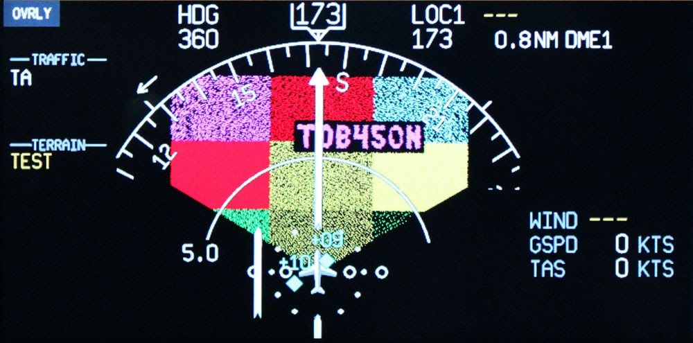
Pilots who fly aircraft equipped with Honeywell TAWS equipment can easily determine what database version is installed in their aircraft by invoking the "TAWS Test" function. A multicoloured test screen will appear, and in the middle of the test screen, you will see a number. That number is the version number of the currently loaded database. At the same time, the TAWS will voice several aural alerts (PULL UP, TERRAIN, or similar).
The picture below shows the test screen from a Twin Otter aircraft that has Terrain Data Base (TDB) version 450 installed. The N after the version number means it is an Americas database. An A after the version number would mean an Atlantic database, and a P after the version number would mean a Pacific database.
Hope this information helps.
Michael
Twin Otter TAWS Test Screen
The TAWS that are intended for the commuter and regional aircraft market (for example, the Honeywell MK VI TAWS) can only hold 1/3 of the world. Honeywell has segmented the world up into three regions; Atlantic (Europe, Africa, Middle East), Americas (North and South America, including the western 1/5th of Greenland), and Pacific (Asia, Australia, and the Pacific Coast of North America). The operator chooses the appropriate database for the region that the regional/commuter aircraft will operate in - regional and commuter aircraft being, by definition, not used for intercontinental operations - then loads that database.
TAWS such as the MK V that are intended for use in large aircraft (Boeing or Airbus types) and in long-range corporate aircraft (Gulfstreams, Challengers, anything else that could reasonably be expected to operate intercontinentally) have a much larger flash memory storage capacity, and can hold a global database. The global database is nothing more than all three of the regional databases combined into one file.
The practice of having less flash memory in the regional aircraft TAWS dates from many years ago when flash memory was very expensive. Today, sufficient flash memory to hold the global database would probably only cost Honeywell about $5 per aircraft, however, there are two possible reasons why Honeywell has stuck with the original practice:
1) It's a difficult and painful process to get approval for hardware changes, and the existing model range of TAWS hardware is already approved, and;
2) Cynics might observe that Honeywell can charge a heck of a lot more money than just $5 for the airline and 'heavy iron' TAWS models that can contain a global database. Having hardware for two different segments (regional and intercontinental) allows Honeywell to charge intercontinental operators a premium price, but offer the same hardware at a significantly lower price to small aircraft operators who might be unwilling to pay the price charged to the big aircraft operators.
Anyone at all can go to the Honeywell website and see what the most recent release of TAWS data for the various models of TAWS is. The website (provided earlier in this discussion by another forum member) is Honeywell Aerospace - Database Services. It is necessary to register with Honeywell in order to be able to download the (free) database updates, however, it is not necessary to register - or have any login or password information - in order to find out what the version number of the most current database for your aircraft is. That information is at the bottom of that web page, along with the scheduled date for the next (upcoming) update. You will, however, need to know what kind of TAWS (EGPWS, to use Honeywell's trademark for their version of TAWS) you have installed in your aircraft in order to make sense of the release schedule.
Pilots who fly aircraft equipped with Honeywell TAWS equipment can easily determine what database version is installed in their aircraft by invoking the "TAWS Test" function. A multicoloured test screen will appear, and in the middle of the test screen, you will see a number. That number is the version number of the currently loaded database. At the same time, the TAWS will voice several aural alerts (PULL UP, TERRAIN, or similar).
The picture below shows the test screen from a Twin Otter aircraft that has Terrain Data Base (TDB) version 450 installed. The N after the version number means it is an Americas database. An A after the version number would mean an Atlantic database, and a P after the version number would mean a Pacific database.
Hope this information helps.
Michael
Twin Otter TAWS Test Screen
It's also worth mentioning that if pilots are really curious about what data is contained in their Honeywell EGPWS database, it is possible to go to a different Honeywell website and download an Excel spreadsheet that lists every single runway at every single airport that is contained in the world database.
This document does not tell you what areas of the world (away from runways) have been mapped for terrain height, or with what precision (in arc-seconds) various areas of the world have been mapped for terrain height, but it does tell you which runways ('runways' implies final approaches) have been mapped. When a runway is included in the terrain database, the TAWS will know that it is 'acceptable' for the aircraft to descend closer and closer to the ground (eventually reaching the ground and landing on it), provided that the aircraft stays laterally within the appropriate confines of the extended centerline, and provided that the vertical descent path angle of the aircraft is 'sensible' for the runway to which the approach is being conducted.
Other factors are also considered during the final approach - radar altitude, glideslope deviation, aircraft configuration, rate of descent, and so forth - to determine whether the TAWS stays silent or whether it generates an alert, but, if a particular runway has been mapped for the database, this means that the likelihood of hearing a spurious terrain alert during approach is very, very low; provided that the aircraft follows a published approach.
Here is the website you can go to to download all the details about the current database release: Honeywell EGPWS Airport / Runway Search. You can also enter the Airport Name, City Name, Country Name, or ICAO Airport Identification Code and look up specific information that way, without having to download the entire Excel document.
Michael
