


BE1900 IMC CFIT in Alaska

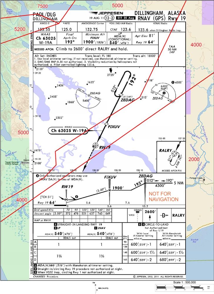
Looking at the chart, one could fly inbound from ZEDAG to the FAF at 1,900' which I'm guessing was the the reason for the "cross ZEDAG at 2,000 or above" clearance. The late request for the hold was what led to the CFIT. AFAWK, neither the controller, nor the crew took action to CLIMB to the 4,300' MHA. The terrain on th final approach course is fairly flat.
The course inbound is 13nm to accommodate the gradient for the intermediate segment which is dictated by the terrain in the course reversal hold. It is 316'/nm from the IF to the FAF, as it is.
I'm not so sure making it standard would have lowered the MHA. There is more terrain than depicted.
The course inbound is 13nm to accommodate the gradient for the intermediate segment which is dictated by the terrain in the course reversal hold. It is 316'/nm from the IF to the FAF, as it is.
I'm not so sure making it standard would have lowered the MHA. There is more terrain than depicted.
Last edited by galaxy flyer; 17th Mar 2013 at 19:43.

Per Ardua ad Astraeus
Join Date: Mar 2000
Location: UK
Posts: 18,579
Likes: 0
Received 0 Likes
on
0 Posts
Had the pattern been on that side it appears very likely they hadn�t hit the rocks.
At 4300' there are no obstacles, left or right. There is only one reason they 'hit the rocks'.
Last edited by BOAC; 17th Mar 2013 at 19:46.

Annex14 said:
Strange, in my current and past 34 years of instrument flying, standard holdings were and are right hand turns. (Looks like OK465 beat me too it).
But in my - past world - there was a preference and that was called left hand standard pattern.
Last edited by oceancrosser; 17th Mar 2013 at 20:26.
Join Date: Dec 2010
Location: S 51 N
Age: 84
Posts: 196
Likes: 0
Received 0 Likes
on
0 Posts
pattern
Okay gentlemen, before we go too far off track I admit my phrasing was misleading.
For the sake of a correct discription I cite what is written in ICAO DOC 8168 PANS - OPS Vol. II - Part VI, chapter 1:
The criteria contained in this part are related to right turns holding patterns. If no operational considerations prevail, right turns holding patterns should be established. For left turns holding patterns, the corresponding entry and holding procedures are symmetrical with respect to the inbound holding track.
Hope that helps.
Pegase Driver
Join Date: May 1997
Location: Europe
Age: 74
Posts: 3,681
Likes: 0
Received 0 Likes
on
0 Posts
Thanks Annex 14 ( nice appropriate name btw ) I know myself of a few published left hands Holdings around some large airports .
BOAC : OK, " crazy" was perhaps not the best adjective to use, grant you that, what I meant was that if you look at the terrain , and you do not depend on a fixed ground Nav aid , I pesonally would think that in this case, drawing a virtual IAF 10 NM away and with LH pattern would make a lot of common sense.. But I am not a procedural map producer.
BOAC : OK, " crazy" was perhaps not the best adjective to use, grant you that, what I meant was that if you look at the terrain , and you do not depend on a fixed ground Nav aid , I pesonally would think that in this case, drawing a virtual IAF 10 NM away and with LH pattern would make a lot of common sense.. But I am not a procedural map producer.

Guest
Thread Starter
Join Date: Apr 2009
Location: On the Beach
Posts: 3,336
Likes: 0
Received 0 Likes
on
0 Posts
ok465:
I think you mean to say that flight inspection cannot possibly check for possible errant blunders.
There is nothing wrong with the design of this procedure under FAA policy and design criteria.
These procedures are all flight checked by people with 'real flying experience' before release, as well as 'flight validated' in a simulator even before the in-flight check using stringent guidelines that include checks at temperature and wind extremes.
They cannot, however, be checked for all possible specific RNAV system operational issues.
They cannot, however, be checked for all possible specific RNAV system operational issues.
There is nothing wrong with the design of this procedure under FAA policy and design criteria.
Guest
Thread Starter
Join Date: Apr 2009
Location: On the Beach
Posts: 3,336
Likes: 0
Received 0 Likes
on
0 Posts
GF:
With those MIAs, how could the controller issued the "at or above 2,000 feet" clearance? Is there a lower MVA?
No MVAs. This is center airspace. MIAs are used as MVAs when they have radar contact.
Consider those to be center MVAs on the chart.
Aterpster
With those MIAs, how could the controller issued the "at or above 2,000 feet" clearance? Is there a lower MVA?
Consider those to be center MVAs on the chart.
That I understand, what doesn't make sense is the clearance "at or above 2,000'" when the plane was in an area where the MIA was 4,000 or 5,000.
From the NTSB preliminary:
From the NTSB preliminary:
The ARTCC specialist on duty subsequently granted the request by issuing the clearance, with instructions to proceed direct to the Initial Approach Fix (IAF) to begin the approach, and to maintain an altitude of 2,000 feet or above. A short time later the flight crew requested to enter a holding pattern at the IAF so that they could contact the Flight Service Station (FSS) for a runway conditions report,
Last edited by galaxy flyer; 21st Mar 2013 at 02:48.
what doesn't make sense is the clearance "at or above 2,000'" when the plane was in an area where the MIA was 4,000 or 5,000.
My reading is also (for the moment, pending further details) that both the controller and the crew lost situational awareness - they didn't notice that the terrain situation was going to change rapidly in the near future.
I don't know for certain what information the controller had (or should have had) in front of him - I presume that will come out eventually. I do know what information the pilot had (or should have had) in front of him - and it is a chart that in TWO places says, "If you are going northeast of ZEDAG, you must be at 4300 feet to remain safe!"
Given two advisories that do not actually conflict:
ATC - "at least 2000 feet or higher"
Chart - "at least 4300 feet"
- which altitude would/should a pilot choose?
This may be of interest - although it does not go very far in clarifying the situation:
A flightcrew should be generally aware of terrain and obstruction elevations and should never accept instructions that do not ensure adequate terrain clearance. A controller is required to issue a safety alert to an aircraft if the controller is aware the aircraft is in a position/attitude that, in his/her judgment, places the aircraft in unsafe proximity to terrain or obstructions. Air traffic controllers issuing specific altitude instructions and clearances accept responsibility for terrain avoidance.
Pilot charts depict minimum en route altitudes, minimum obstruction clearance altitudes, off route obstruction clearance altitudes, and other altitudes. Minimum vectoring altitudes, available only to ATC, can sometimes be the best and lowest altitudes available for instrument flight. Pilots receiving altitude assignments below charted altitudes typically assume they are being assigned the minimum vectoring altitude.
Pilot charts depict minimum en route altitudes, minimum obstruction clearance altitudes, off route obstruction clearance altitudes, and other altitudes. Minimum vectoring altitudes, available only to ATC, can sometimes be the best and lowest altitudes available for instrument flight. Pilots receiving altitude assignments below charted altitudes typically assume they are being assigned the minimum vectoring altitude.
Guest
Thread Starter
Join Date: Apr 2009
Location: On the Beach
Posts: 3,336
Likes: 0
Received 0 Likes
on
0 Posts
pattern is full:
The controller should have had the FAA approach chart in front of him as well as training and knowledge that the FAA 8260-2 holding pattern form specified the same holding pattern and minimum holding altitude as shown for ZEDAG.
If the pilot can actually choose the altitude, based on the chart he should have been not less than 5,400 prior to entering the south TAA area. If the controller decided to clear the flight direct to ZEDAG the assigned altitude should have been not less than 5,000.
The controller had the primary responsibility to not let the flight be below 5,000 if cleared direct to ZEDAG, or not less than 5,400 prior to the flight crossing the boundary of the TAA if it was to be "own nav."
"At or above 2,000" conflicts with the altitudes required to be assigned in the circumstances.
No doubt the crew was also asleep at the switch.
The lawyers will have a field day with this one.
I don't know for certain what information the controller had (or should have had) in front of him - I presume that will come out eventually. I do know what information the pilot had (or should have had) in front of him - and it is a chart that in TWO places says, "If you are going northeast of ZEDAG, you must be at 4300 feet to remain safe!"
Given two advisories that do not actually conflict:
ATC - "at least 2000 feet or higher"
Chart - "at least 4300 feet"
- which altitude would/should a pilot choose?
Given two advisories that do not actually conflict:
ATC - "at least 2000 feet or higher"
Chart - "at least 4300 feet"
- which altitude would/should a pilot choose?
If the pilot can actually choose the altitude, based on the chart he should have been not less than 5,400 prior to entering the south TAA area. If the controller decided to clear the flight direct to ZEDAG the assigned altitude should have been not less than 5,000.
The controller had the primary responsibility to not let the flight be below 5,000 if cleared direct to ZEDAG, or not less than 5,400 prior to the flight crossing the boundary of the TAA if it was to be "own nav."
"At or above 2,000" conflicts with the altitudes required to be assigned in the circumstances.
No doubt the crew was also asleep at the switch.
The lawyers will have a field day with this one.
Join Date: Jun 2003
Location: Canada
Age: 68
Posts: 261
Likes: 0
Received 0 Likes
on
0 Posts
"If you are going northeast of ZEDAG, you must be at 4300 feet to remain safe!"
Guest
Thread Starter
Join Date: Apr 2009
Location: On the Beach
Posts: 3,336
Likes: 0
Received 0 Likes
on
0 Posts
604 guy:
Where do you come up with 4 N.M?
Interesting to note on the chart that the profile view indicates a 5nm holding pattern at an altitude of 4300'. The plan view however indicates that 4300' in that area northeast of ZEDAG is good out to 4nm only. Beyond that in that direction the plan view says 6300'. Yes that is for straight in and no procedure turn but that is the type of information that would be a strong cue to me that there is likely rapidly rising terrain in the vicinity and that any altitudes provided by ATC less than depicted would warrant a query to verify that ATC will be providing terrain separation at all times.
Guest
Thread Starter
Join Date: Apr 2009
Location: On the Beach
Posts: 3,336
Likes: 0
Received 0 Likes
on
0 Posts
No, the inner TAA area is 4 n.m. in the straight-in TAA area (the north side). The holding pattern is 5 n.m, shown in the profile view. The holding pattern would generally be used only when arriving from within the south TAA are (the one with a single altitude of 5,400).
Check the FAA's version of the chart. Perhaps it is clearer in this respect:
http://aeronav.faa.gov/d-tpp/1303/05166R19.PDF
Check the FAA's version of the chart. Perhaps it is clearer in this respect:
http://aeronav.faa.gov/d-tpp/1303/05166R19.PDF
Last edited by aterpster; 21st Mar 2013 at 18:24.
Per Ardua ad Astraeus
Join Date: Mar 2000
Location: UK
Posts: 18,579
Likes: 0
Received 0 Likes
on
0 Posts
No, the inner TAA area is 4 n.m. in the straight-in TAA area (the north side). - so if I have this right, on these 'new' RNAV charts, the min hold alt will always be the lowest of the TAA values? NB I have never flown one of these procedures, so, if I am approaching ZEDAG on the 103 for an RNAV19, I assume I maintain 6300 until 4nm when I can start descent to 1900 and begin the turn onto final? If I want to join the hold from that inbound, what then - the same but this time to 4300'? Is that the way it works?
I take it there are no other instrument approaches onto 19 there?
I take it there are no other instrument approaches onto 19 there?