


A Sukhoi superjet 100 is missing

Moderator
Thus they would be idiots not to make a big show of this being an impartial and transparent investigation. It carries a small risk of evidence leading in an unexpected direction, but less risk (given appearances so far) than if they seem to be hiding something. That could kill the whole project.
There are a number of historical incidents of demo flights gone wrong, and it's appaerently just been easier to blame the pilot (particularly when he cannot defend himself). The demo flight is a less than ideal situation for safety. Operations outside the "normal" procedures of commercial transportation, and making the most of the plane's performance to impress people - a challenging combination....

Join Date: Jun 2002
Location: SE Asia
Posts: 141
Likes: 0
Received 0 Likes
on
0 Posts
Not the First
Interesting perspective on the dangers of flying in this area.
Mt. Salak: An airplane graveyard | The Jakarta Post
Mt. Salak: An airplane graveyard | The Jakarta Post
Join Date: Dec 2008
Location: PDX
Posts: 72
Likes: 0
Received 0 Likes
on
0 Posts
(Not a pilot) As asked on another forum: Were the two planned flights that day to use the same flight path? Was the cockpit crew the same for both flights?
Finally, how close is the fatal flight path to the successful flight path?
Finally, how close is the fatal flight path to the successful flight path?

Join Date: May 2012
Location: Indonesia
Posts: 3
Likes: 0
Received 0 Likes
on
0 Posts
Sukhoi Superjet-100 hits mountain top
It has been a very long time since I piloted a plane, but was happy to find this forum. I live about 13 km NW of the point of impact. I can see Mount Salak on a clear day and perhaps could see the site with binoculars. I came across the forum, because of my problem to understand the coordinates given by search personnel on the local TV (61 seconds!?) in one of the coordinates. Using the decimal conversion proposed by another poster, which look to be correct and fit fairly well with a report from one of the search pilots who gave the altitude as 5,800 ft. Java lies E-W, with a chain of volcanic mountains along the island. Here in West Java Mounts Salak I (7,287 ft), Salak II (7,153 ft) Gede (9,705 ft) and Pangrango (9,905), all lie to the south. Flying from on the north coast to Pelabuhan Ratu, a small fishing village on the south coast would only take a few minutes and I suspect that was the plan. On the return the pilot had requested to descend from 10,000 to 6000 ft and that was before passing over the above mentioned mountains. Yesterday afternoon in the town of Bogor (400 m asl) it was overcast and I did hear an unusual sound above, but paid little notice because there is a nearby airfield. It is probable that the mountains were entirely covered by cloud. What I cannot understand is that, with a navigator on board, why the request to descend was made so soon. I also assume that he would be aware of the MOCA (at least 10,000 ft?). Also surely a new aircraft would have a ground proximity warning system. Would this help? Perhaps not if you fly into a vertical mountainside. Regarding the weather, Bogor is known as Rain Town and has the national record for lightning strikes. Although we used to have a dry period of several weeks or even months, we haven�t had a long dry period for a couple of years (climate change) and often get heavy rain especially in the afternoon. I can�t remember when I last saw the mountains. Retrieval of the remains will be an enormous problem and I guess it will take 6-8 hours on foot to reach the site from the nearest road.
Join Date: May 2012
Location: Indonesia
Posts: 3
Likes: 0
Received 0 Likes
on
0 Posts
Definitely the same pilot, co-pilot and navigator according to the reports. The flight paths may have been different. Also, even if not, the cloud cover probably increased from morning to afternoon.
Join Date: Mar 2006
Location: Choroni, sometimes
Posts: 1,974
Likes: 0
Received 0 Likes
on
0 Posts
Join Date: Jul 2011
Location: Duxford
Age: 45
Posts: 142
Likes: 0
Received 0 Likes
on
0 Posts
Disclaimer: I have no experience of airliner crashes at all.
But, it strikes me as slightly strange if this was CFIT and the aircraft impacted a virtually sheer cliff at normal cruise speed that, according to a number of comments, there are pieces of wreckage large enough to be mistaken for the aircraft 'breaking in two'.
Surely if it impacted a cliff as above it would be such an intense impact it would virtually disentigrate?
Just one for our ATC colleagues, if I do request a descent to below MSA in an area, what sort of response back would I expect ? Just a clearance without comment ?
Join Date: Apr 2010
Location: London
Posts: 7,072
Likes: 0
Received 0 Likes
on
0 Posts
Padre describes the area quite well -
the weather is NOT "unpredictable" - it is all too predictable
often nice clear still mornings then around 11:00 cumulus starts to bubble up - you can pretty much guarantee rain and thunderstorms around Bogor starting at 13:00 - 13:30 clearing round 16:00 throughout the year - except maybe for a few days in June/July
For a long time Bogor was in the records as the thunderstorm capital of the world
Looks like he clipped a ridge coming off Gunung Salak - a couple of kms further north and he'd have had a lot of clear air under him but ..........
Join Date: May 2004
Location: 3.5 from TD
Age: 47
Posts: 1,042
Likes: 0
Received 0 Likes
on
0 Posts
Just one for our ATC colleagues, if I do request a descent to below MSA in an area, what sort of response back would I expect ? Just a clearance without comment ?
Extremely poor service from the controllers in this part of the world, just a matter of fact unfortunately - and pretty unsurprising considering the overall safety culture of the Indonesian aviation industry. Bad English and complete disregard for established safety procedures. With the drastic increase in traffic these days, it is downright dangerous.
But with that, it is still no excuse for a pilot loosing SA and descending below MSA. Although, in this case, I think it was probably more a case of trying to showboat to the VIPs and pushing the envelope a little too much. The aircraft was circling the mountain, so I am sure they were aware of the terrain. They got too close to it, visual illusion looking past the ridge (it is all jungle covered after all), or got caught somewhere outside the performance envelope of the aircraft due to weather or disorientation.
Hopefully we will find out.

Join Date: Nov 2010
Location: EU
Posts: 626
Likes: 0
Received 0 Likes
on
0 Posts
If the mountain is 5300ft high, I wonder how they hit it after only being cleared 6000.
Edit: I misread something. Peak was over 6000ft, makes sense now.
Edit: I misread something. Peak was over 6000ft, makes sense now.
Last edited by pudoc; 10th May 2012 at 13:28.
Join Date: Feb 2010
Location: Thailand
Posts: 11
Likes: 0
Received 0 Likes
on
0 Posts
If the mountain is 5300ft high, I wonder how they hit it after only being cleared 6000.
<snip>
The Air Force said the aircraft impacted the edge of a cliff (top of the cliff at 6250 feet MSL) about 1.7 nm from Cijeruk. Approximate final position of the aircraft is S6.7045 E106.7373.
I'm guessing it's a very steep and long drop.
Join Date: May 2012
Location: Indonesia
Posts: 3
Likes: 0
Received 0 Likes
on
0 Posts
Mount Salak has two craters, Salak I is 7,254 ft (my earlier post was slightly in error) and Salak II 7,153 ft. The first SAR helicopter pilot reported the wreckage at 5,800 ft, but that may have been below the point of impact. I think the top of the ridge in the photographs is around 2,000 m (6,600 ft).
But with that, it is still no excuse for a pilot loosing SA and descending below MSA. Although, in this case, I think it was probably more a case of trying to showboat to the VIPs and pushing the envelope a little too much. The aircraft was circling the mountain, so I am sure they were aware of the terrain.
But by all accounts they weren't sightseeing because they were in cloud. And cloud, and by the sound of it rain, in close proximity to mountains, would typically mean turbulence, surely the last thing to expose the journalists etc on a jolly to.
Join Date: Apr 2006
Location: ESSL
Age: 79
Posts: 61
Likes: 0
Received 0 Likes
on
0 Posts
Indeed, although I am sure we wonder what aspect of commercial jet operation is served by demonstrating to the prospective customers sightseeing manoeuvring close to mountains, especially as they were probably focused on the Champanska instead.
Join Date: Feb 2007
Location: Expatsylvania
Posts: 179
Likes: 0
Received 0 Likes
on
0 Posts
Please forgive my speculation, but would it not be fairly easy for the GPWS/TAWS to have been MEL'd at some point on this sales excursion, particularly since the aircraft isn't engaged in public carriage? That would also explain the picture of the aircraft's overhead panel, taken on the ground some time prior to the accident, with the TAWS - Terrain button clearly indicating "OFF".
I know it's quite a logical leap, and I'm not at all familiar with this particular aircraft type, but is "GPWS/TAWS switch OFF" part of a normal on-the-ground procedure for anyone here who flies modern jet aircraft? I'm trying to remember if it's ever been a part of my flow/checklist on anything I've flown, but I'm drawing a blank
(edit: The photo in question, TAWS switches on the left hand side, close to the top)
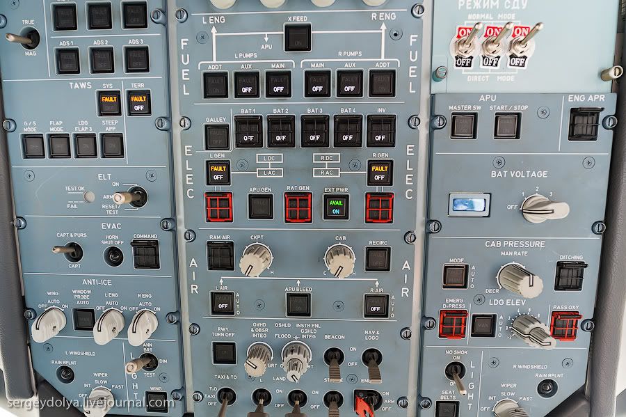
Last edited by thepotato232; 10th May 2012 at 10:48.