


Google Earth flight paths

I'll get me coat......
Thread Starter
Join Date: Sep 2002
Location: Gold Coast, Australia.
Age: 51
Posts: 532
Likes: 0
Received 0 Likes
on
0 Posts
Google Earth flight paths
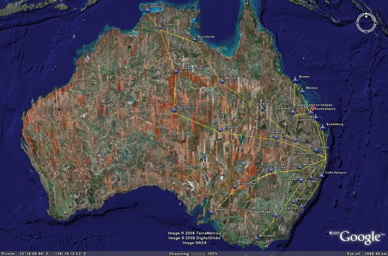
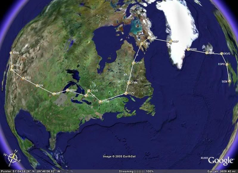
Thought it might be interesting for ppruners to post their longer flights overlaid on Google Earth.
Create a path in Google Earth then click on File, Save, Save Image.
Here's a few of my flights over the last couple of years.
Just an idea.....
CH
Create a path in Google Earth then click on File, Save, Save Image.
Here's a few of my flights over the last couple of years.
Just an idea.....
CH
Last edited by Capt Hollywood; 24th Jan 2008 at 00:58.


Just enough from what I've heard........They fitted a ferry tank in the Baggage Compartment, I believe they had 5 hours "ish".
But i also believe it was an amazing trip..........."maybe someday eh Vertical" now that your Busy in the North Sea
But i also believe it was an amazing trip..........."maybe someday eh Vertical" now that your Busy in the North Sea

buggar...cant fit my 1980 trip. Tried to attach a .kmz file from Google earth but that didnt work !
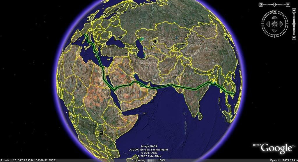
Exmouth Broome Kupang Denpasar Djakarta Singapore Hadyai Bangkok Rangoon Calcutta Nagpur Ahmedabad Karachi Bahrain somewhere in Saudi ..then Jeddah I think... Luxor Cairo Iraklion Athens Naples Marsailes (spellink goin to r/s due one too many G&T) Mustard ...eh ? somewhere in France where they have great mustard....arh yes DIJON....then finally Shannon on St Patrick;s day. I will never forget the Irish Custom's officers when they came on board. "well lads , it is St Paddy's day. Lets just go down the pub and we'll do the clearance tomorrow" Lovely people. What a contract. Best ever.
Exmouth Broome Kupang Denpasar Djakarta Singapore Hadyai Bangkok Rangoon Calcutta Nagpur Ahmedabad Karachi Bahrain somewhere in Saudi ..then Jeddah I think... Luxor Cairo Iraklion Athens Naples Marsailes (spellink goin to r/s due one too many G&T) Mustard ...eh ? somewhere in France where they have great mustard....arh yes DIJON....then finally Shannon on St Patrick;s day. I will never forget the Irish Custom's officers when they came on board. "well lads , it is St Paddy's day. Lets just go down the pub and we'll do the clearance tomorrow" Lovely people. What a contract. Best ever.
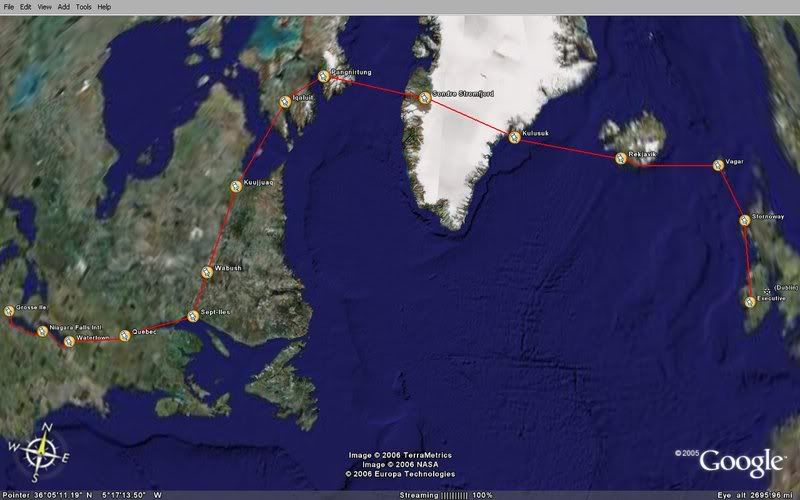
Ten years later (1990)
Vancouver across Canadia to Greenland , Iceland on to Bombay.
Now that was quite an adventure with my good buddy Blaine Forman.
If I could only do Singapoore EAST to Vancouver I would be able to claim "around the world in a 61".
Dont think it will happen. poor old 61 has been relegated to the dinosaur category

Join Date: Aug 2008
Location: Germany
Posts: 37
Likes: 0
Received 0 Likes
on
0 Posts
I am interested which type of GPS receivers/loggers did you use to store the flown tracks. and what setups and programs are you using.
I am using a Garmin 60 CSX with external antenna, sticking to the overhead window in the helicopter.
My other device is a Qstarz BT-Q1000X which can log at max 4 times/second (if ever needed).
I am using a Garmin 60 CSX with external antenna, sticking to the overhead window in the helicopter.
My other device is a Qstarz BT-Q1000X which can log at max 4 times/second (if ever needed).

I'll get me coat......
Thread Starter
Join Date: Sep 2002
Location: Gold Coast, Australia.
Age: 51
Posts: 532
Likes: 0
Received 0 Likes
on
0 Posts
Part of a GPS track that departs Emerald for Blackwater then over the Blackwater mine in Queensland, Australia.
Full track.
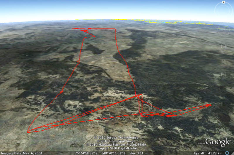
Full track.
Last edited by Capt Hollywood; 23rd May 2010 at 06:35.
in answer to Flighttest-Engineer........
firstly....my good buddy warns me...dont post to Pprune when S___t faced ! Well ya got me again. But as I said to him , ya gotta provide a bit of entertainment sometimes.
Re the query from Flttest-engineer.....when I did the first big ferry there was no such thing as GPS. We had VLF-OMEGA but it was useless so we used conventional ADF VOR DME + finger on an ONC chart. VLF Omega BTW was a system primarily for submarines !
Second big ferry we did have LORAN C but it only had limited coverage...big gaps as I remember , anywhere where the Yanks had no interest.
What an adventure.....and it still is
Join Date: Aug 2008
Location: Germany
Posts: 37
Likes: 0
Received 0 Likes
on
0 Posts
Thank you for your reply.
Maybe I have not placed my first question precisely enough:
I meant the technique behind the actual (live) track recording used during the flight. Setting up a route and to display it in GE might be intersting and informative, but I prefer to track the real track and to display it afterwards by convetring it to adequate format for display on a map or in GE.
I am fully familiar with the Omega Navigation System (I have been a member of the intl. Omega Association years ago). Loran C is also no miracle to me (I had it installed on a boat before GPS was available).
For the dislay of a flown track I am also using the recorded LAT/LONG parameters from the flight recorder (where available and acessible) and I am generally interested in the used different technical solutions.
Last edited by flighttest-engineer; 3rd Jun 2010 at 07:10.
