


How would you fly PAJN LDA X Rwy 08 Approach?

Thread Starter
Join Date: Oct 2013
Location: Seoul
Posts: 14
Likes: 0
Received 0 Likes
on
0 Posts
How would you fly PAJN LDA X Rwy 08 Approach?
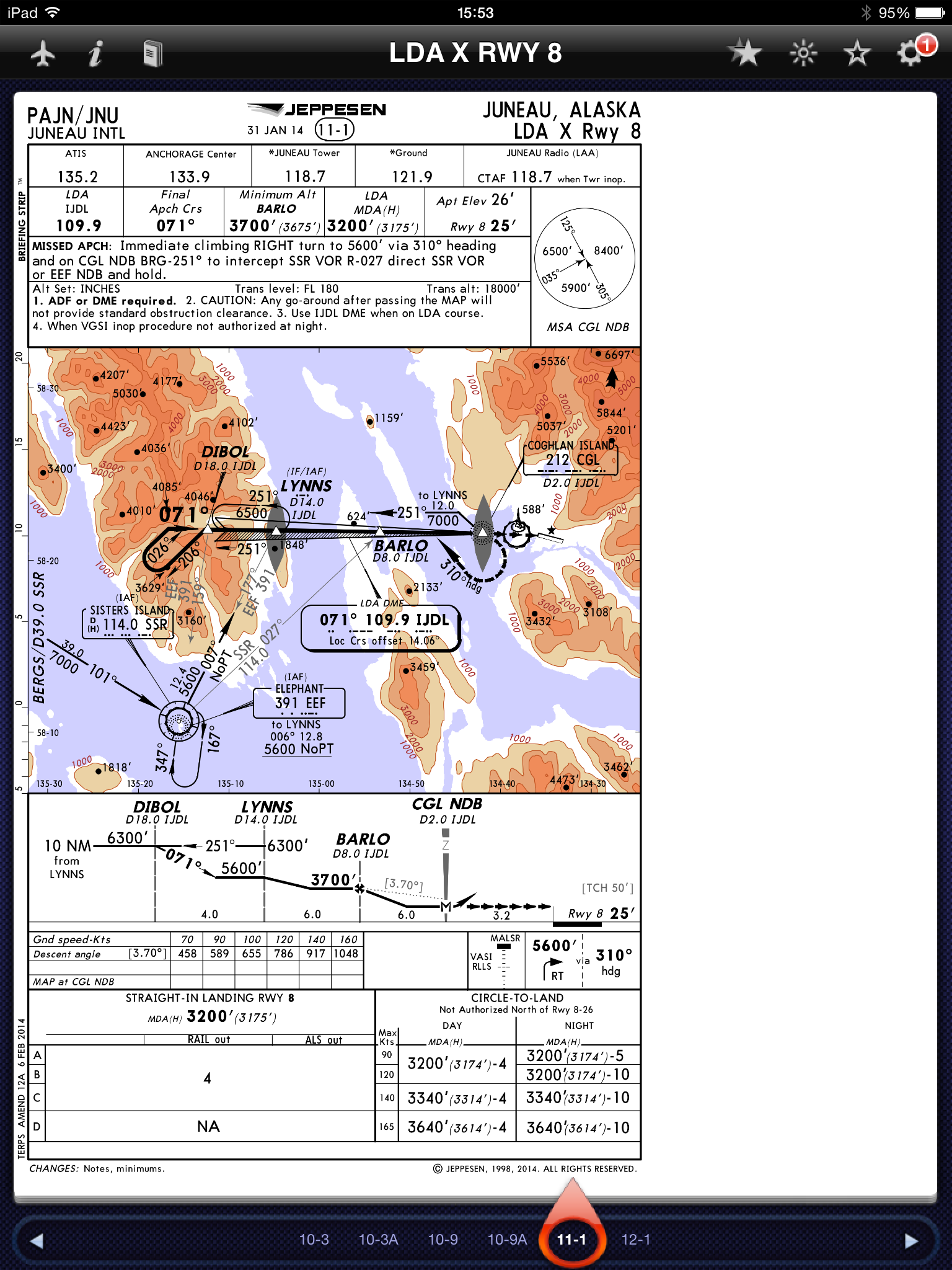
Please refer to the PAJN LDA X Rwy 8 approach chart.
According to the chart, MAP to the threshold is 3.2 nautical miles.
So we have to loose almost 3000 ft for only 3.2nm? I don't think that's usual flight. How would you do this approach?
According to the chart, MAP to the threshold is 3.2 nautical miles.
So we have to loose almost 3000 ft for only 3.2nm? I don't think that's usual flight. How would you do this approach?

Josh,
The minima has almost nothing to do with the MAP. Minima is the altitude at which you must be visual, MAP is the position where you must carry out the missed approach if not visual.
MAP is often past the threshold hence absolutely geometrically impossible to land after passing. This MAP is similar, not doable from minima.
Naturally circling is an option if you get visual late.
Join Date: Jun 2002
Location: Wor Yerm
Age: 68
Posts: 4
Likes: 0
Received 0 Likes
on
0 Posts
Assuming you this with a 3.7˚ descent you'll be about 8 nm at 3,200'. But I'd fly this approach as you would for any other localiser only approach, but with the proviso that a missed approach after MDA will be non-standard - you'll have to be creative. Personally, whilst climbing I'd follow the approach track, track the runway and then follow the standard departure from Rwy 08. For an N-1, I'd do the same and then follow the non-std N-1 profile, all the time knowing that I already had a fair bit of height in the bag.
Piltdown Man, why does a missed approach after the MDA have to be non standard? A standard missed approach would be to track to the MAP then conduct the missed approach. Why could you not do that?
Join Date: Mar 2013
Location: EU
Posts: 497
Likes: 0
Received 0 Likes
on
0 Posts
Read note 2.
A go around after passing the MAP will not provide standard obstacle clearance.
If you want to fly the published missed approach then really you MUST go around no later than the MAP. Otherwise you have to improvise.
A go around after passing the MAP will not provide standard obstacle clearance.
If you want to fly the published missed approach then really you MUST go around no later than the MAP. Otherwise you have to improvise.
Join Date: Dec 2006
Location: Hamburg
Age: 46
Posts: 432
Likes: 0
Received 0 Likes
on
0 Posts
Per Ardua ad Astraeus
Join Date: Mar 2000
Location: UK
Posts: 18,579
Likes: 0
Received 0 Likes
on
0 Posts
Not quite the answer? Do I assume that a curving approach needs to be flown probably down to wings level at about 300'? Starts to get interesting at Cat C.
Read note 2.
A go around after passing the MAP will not provide standard obstacle clearance.
If you want to fly the published missed approach then really you MUST go around no later than the MAP. Otherwise you have to improvise.
A go around after passing the MAP will not provide standard obstacle clearance.
If you want to fly the published missed approach then really you MUST go around no later than the MAP. Otherwise you have to improvise.
Guest
Join Date: Apr 2009
Location: On the Beach
Posts: 3,336
Likes: 0
Received 0 Likes
on
0 Posts
Here are the Jepp airport diagram and a topo snippet of the critical area. If you think this approach is weird, keep in mind the minimums are above basic VFR. What is really interesting if the IFR takeoff on Runway 8, where you must level at 1,000, and turn into very high terrain (while avoiding it visually) until clear of the close-in terrain:


Guest
Join Date: Apr 2009
Location: On the Beach
Posts: 3,336
Likes: 0
Received 0 Likes
on
0 Posts
In the late summer of 1971 an Alaska Airlines 727-100 crash into terrain at the approximate point indicated by the green arrow. 111 people perished. They were arriving straight-in on terminal routing from the west.
The NTSB couldn't really figure out what happened so they punted to "misleading navigation display for reasons undetermined:"
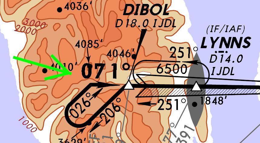
The NTSB couldn't really figure out what happened so they punted to "misleading navigation display for reasons undetermined:"
Join Date: Jan 2014
Location: glendale
Posts: 819
Likes: 0
Received 0 Likes
on
0 Posts
getting back to the question, in some planes you might not be able to fly this approach well, easily and legally.
it is important to note the arrows after the MAP indicating that this portion of the approach is visual reference.
as a practical matter if you didn't have the runway in sight about 8 miles from the runway, you might not get in with an easy, stable approach. IF you did have the runway in sight you would have to continue descending below the MDA to maintain the stable approach criteria.
So, if you stayed at the MDA to the MAP and then WENT FOR IT, you would have to get CREATIVE in your flying. Or just enter the traffic pattern from the overhead and circle to land if too high.
This is the country of the bush pilot and he could probably get in just fine while eating a ham sandwich and telling a joke about a Kodiak bear and a fisherman's daughter.
Thanks for the charts. Sporty as you say. I'd like to see the Magenta Line kids try that.
https://www.faa.gov/about/office_org...NU_LOA_R18.pdf
Page 13 has a copy of the RNP approach down the channel.
Anyway, back to the chart, there's a special approach that follows the same track, just with much lower MDA, 1000 ft. The trade off if I remember correctly is a healthy FPNM climb gradient. The training requirement of the 8260 for the approach requires sim training with graphics specific to JNU or in aircraft. Funny enough, it doesn't state any currency requirements like other specials.
Last edited by West Coast; 2nd Oct 2014 at 02:04.
