


GPS altitude

Thread Starter
Join Date: Jun 2003
Location: EuroGA.org
Posts: 13,787
Likes: 0
Received 0 Likes
on
0 Posts
GPS altitude
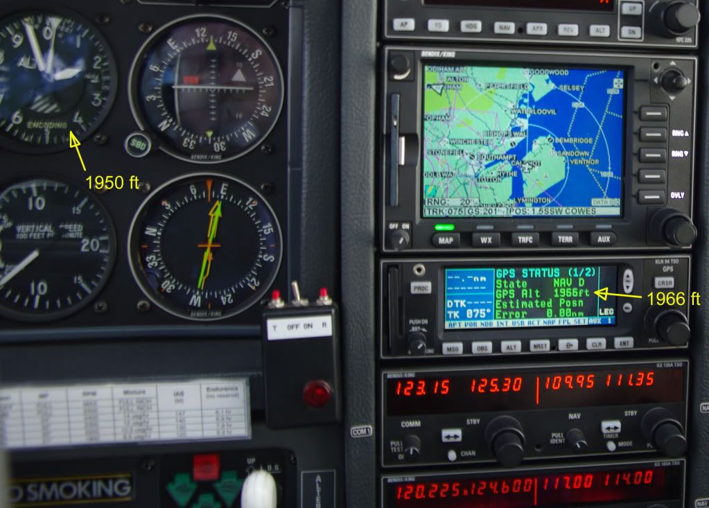
The 16ft difference is about half a millibar so insignificant given the QNH setting error.
This kind of accuracy is completely normal and I see it on every flight, over the past 7 years.
This is an IFR GPS but even modern cheap and dirty handhelds (Sirf-3 chip or later) get within 100ft. An EGNOS receiving unit (which currently has to be a handheld) like a Garmin 496 is routinely within 10ft.


Pressure altimeters have 3 main errors (forget the daft RAF 'PITCHBLOT' nonsense):
1. No machine is perfect, so instrument error, lag and hysterisis will affect any such altimeter to a degree.
2. Installing an altimeter in an aircraft will induce certain errors, such as position error and cockpit temperature.
3. Even if both altimeter and installation are 100% perfect (impossible), the atmosphere in which the aircraft is flying probably isn't 100% International Standard Atmosphere, to which the altimeter is calibrated.
These errors may be additive or subtractive - but they will always be there.
A good pressure altimeter is probably accurate to �30 ft - but that also assumes that the pressure setting datum is accurate.
I don't know whether GPS altitude is measured against an estimate of local sea level with reference to the Earth's centre - 'sea level' is not the same world-wide. Or whether an assumed perfect oblate spheroid provides the GPS datum?
Whatever. GPS altitude is a useful back-up, but that is all. It could only be used as a separation standard if everyone carried GPS and used the same 'earth model'. Which, outside CAS, will never happen.
Mind you, when the OAT was +3 deg C and it was getting wet outside, I was very glad to know my GPS altitude and, assuming 2 deg/1000 ft, to be able to assess the risk of ice....
...whilst driving through the Eifel on non-winter tyres, that is!

Join Date: Jun 2005
Location: LONDON
Posts: 128
Likes: 0
Received 0 Likes
on
0 Posts
GPS altitude is a useful back-up, but that is all
ESA - Navigation - The present - EGNOS - EGNOS ?Open Service? available: a new era for European navigation begins today
I agree that it may not be much use for relative separation as yet but plenty of other applications such as cloud breaks and approaches !
Drambuster
Last edited by drambuster; 27th Nov 2009 at 22:10.
Join Date: Oct 2006
Location: London
Posts: 423
Likes: 0
Received 0 Likes
on
0 Posts
I don't know whether GPS altitude is measured against an estimate of local sea level with reference to the Earth's centre - 'sea level' is not the same world-wide. Or whether an assumed perfect oblate spheroid provides the GPS datum?
It is best explained by starting with how LNAV works. LNAV is based on a ellipsoid (a perfect, regular geometric shape) model of the earth. Both GPS and aviation charts (at least in most developed countries) use the same ellipsoid datum (WGS84, the ICAO standard).
VNAV is measured against a different kind of shape, a geoid. This is irregular and takes into account variations in the earth's composition and form which, in turn, cause local variations in gravity and mean sea level.
GPS altitude is initiallly calculated with reference to the WGS84 ellipsoid as a coordinate and then translated into an altitude using the EGM96 geodetic model for the mean sea level datum.
However, EGM96 is NOT the standard for aviation charts and instrument procedures. There is no standard - a local MSL datum tends to be used. This varying datum is of no relevance to pilots using barometric altimetry, because they will be using a QNH which is referenced to the same local datum as the charts. However, the difference between the local datum and EGM96 could be quite sigificant. Whether the your GPS is accurate to 1ft or 5ft or 10ft doesn't matter if the datums vary by 100ft.
Hence why we have to use barometric altimetry in aviation, for the time being....
brgds
421C
see page 52 of the following link
http://www.pplir.org/images/stories/...vmanual1_8.pdf
Thread Starter
Join Date: Jun 2003
Location: EuroGA.org
Posts: 13,787
Likes: 0
Received 0 Likes
on
0 Posts
Since 1st October EGNOS (European equivalent of WAAS) has been fully operational and certified for "safety critical applications such as flying aircraft". It is accurate to 1 to 2 meters horizontally and 2 to 4 meters vertically so ideal for precision approaches for which it has been designed. (I believe the first trial precision IAP is underway at Heathrow).
Google turns up this and this and many others.
EGNOS has been operational for a number of years now. The signal has been transmitted with a TEST flag set which prevents any IFR GPS from using the signal. Perversely only handhelds can use the signal.
Beagle - I am aware (as most people are) that barometric altimetry has its place, for vertical traffic separation. I posted that image to make the point that the widespread garbage that GPS altitude is way off is just that, garbage.
The baro altimetry errors are complicated. Even a perfect altimeter, set to the perfectly accurate QNH by making it read the exact known elevation prior to departure, will misread substantially under non-ISA conditions at high altitudes. That is why when flying at say 10,000ft the altimeter can be 500ft out, whereas the GPS will still be accurate to, whatever, 20ft.
An IFR GPS contains a means of correcting for the geoid shape. Traditionally this is done using a lookup table an interpolating it as necessary, but one can do it using a polynomial surface. I once found some US Navy website which had some polynomials which delivered the geoid correction, within not many feet, over most of the earth's surface. But this variation is small; of the order of 50ft in N Europe.
In that example on my initial post, I obviously set the altimeter to read the airport's elevation (actually from the ATIS QNH which this time happened to be spot on) and had only flown about 50nm away (pretty well parallel to the isobars, as it happened) and climbed to only 2000ft. I also set the Southampton QNH in that area. So the opportunity for the altimeter to accumulate a significant error was minimal.
Join Date: Jun 2005
Location: LONDON
Posts: 128
Likes: 0
Received 0 Likes
on
0 Posts
Do you have a reference for it being certified for "safety of life" applications?
In the meantime, like IO540, I have been monitoring the accuracy of EGNOS augmented GPS altitude for some years against a rad-alt and have to say it is incredibly accurate when, for example, doing a cloud break over sea. Certainly within 10ft which is more than can be said for the pressure altimeter which can be up to 200 feet inaccurate (not surprising as it set to the regional pressure).
Drambuster
Join Date: Nov 2008
Location: UK
Posts: 267
Likes: 0
Received 0 Likes
on
0 Posts
[OT] plurals
One datum 2 data (not datums)
Thread Starter
Join Date: Jun 2003
Location: EuroGA.org
Posts: 13,787
Likes: 0
Received 0 Likes
on
0 Posts
The announcement that the EGNOS �Open Service� being operational from 1st October does suggest that it is cleared for action
The signal has been there for years. Nothing has changed.
But let me again emphasise - the GPS in that pic (KLN94) does not use EGNOS, yet it delivers an altitude accuracy consistently within tens of feet - at all locations where such can be verified.
Join Date: Apr 2008
Location: Cilboldentune, Britannia
Posts: 555
Likes: 0
Received 0 Likes
on
0 Posts
Flying through Farnborough I was warned that according to my Transponder/Encoder I was 200ft above my declared altitude (altimeter). So from a legal point of view which should I use and could I argue that my altimeter was reading 2400ft and that my encoder was giving wrong information. Bear in mind that the aircraft has an annual radio check, every 3 years the transponder AD is done and that both use the same static source. Some altimeters had the encoder built in (set of revolving discs) which were probably/possibly synchronised. It seems to me that that until we all have transponders displaying altitude we will never know if there is problem between the two. I have my encoder connected to the GPS which I believe reduces the satellite search time; it would nice to see the differences (GPS v Encoder) but I believe there is no way that a GPS could give you accurate height information based on a time algorithm.
Thread Starter
Join Date: Jun 2003
Location: EuroGA.org
Posts: 13,787
Likes: 0
Received 0 Likes
on
0 Posts
I have my encoder connected to the GPS which I believe reduces the satellite search time; it would nice to see the differences (GPS v Encoder)
The altitude input to an IFR GPS is there for RAIM purposes. The baro input reduces (by 1) the minimum # of satellites required, IIRC. It is fairly meaningless these days.
The altitude info could be used to shorted the initial fix time (by putting a constraint on the PLL) but I don't think this is done on aviation units. It is done in more specialised units; for example a GPS combined with a FOG (as on the U.S. GPS guided bombs) can be made highly jamming-immune because of the INS knowing roughly where it is. Worth reading the Volpe report on GPS vulnerability - online somewhere.
but I believe there is no way that a GPS could give you accurate height information based on a time algorithm.
Interestingly, the principle of GPS (correlation of known-timing packets) was even used on Apollo to get precise space vehicle position information; all those years ago.

Join Date: May 2007
Location: Compton Abbas
Posts: 164
Likes: 0
Received 0 Likes
on
0 Posts
Most non-IFR, generic Sirf GPS chipsets, as used in lots of mobile phones and even car satnav devices, also perform the required corrections from ellipsoid altitude to local mean sea level altitude.
In fact the NMEA sentence specification requires such corrections to be performed as the only altitude output should be with regards to local mean sea level. There is another, separate output which is supposed to tell the receiving software what correction has been applied, in case they want to reverse it and actually use ellipsoid altitude. This makes it quite easy to detect when a device has actually given you ellipsoid altitude which on its own is quite useless for flight.
My mobile phone produces a GPS altitude within +/- 20 feet of the altimeter reading.
Join Date: May 2006
Location: .
Posts: 26
Likes: 0
Received 0 Likes
on
0 Posts
I'll second IO540's suggestion of reading the Volpe report if you're interested and have the time:
https://www.navcen.uscg.gov/gps/geni...essrelease.htm
https://www.navcen.uscg.gov/gps/geni...essrelease.htm
Last edited by sjeh; 30th Nov 2009 at 09:31. Reason: fixed link
Join Date: Dec 2008
Location: From Despair To Nowhere
Posts: 130
Likes: 0
Received 0 Likes
on
0 Posts
The reason that GPS altitude should not be used is nothing to do with its accuracy. The reason is that everyone else is using barometric altitudes, and all restrictions such as airspace are defined as barometric altitudes.
jxk
200 feet is within the standards for IFR flight in controlled airspace. Don't worry about it, mention it to your maintainers when convenient. Always fly what your altimeter is saying, having checked the correct subscale setting, unless you have a reason to doubt that it works (like my colleagues sudden apparent ascent to 10,000 feet plus due to a mechanical failure within the instrument!).
Join Date: Jun 2007
Location: Hotel time zone
Posts: 175
Likes: 0
Received 0 Likes
on
0 Posts
My HP GPS/PDA (sirf star 3) does NOT correct for the variations in earth's density/gravity across the globe using the EGM96 geodetic model.
Garmins DO correct. I couldn't work out why there was consistently a approx 100 ft difference between them, until I read about this somewhere.
As it happens, NW Europe sits on an extreme of variance from the WGS84 ellipsoid datum. (I looked for the map of variance, but cant find it). I seem to remember that in the UK, the GPS will over-read by about 140' without correction, and India is an area that under-reads significantly.
In some gliding comps, due to various GPSs used, (some which compensate and some which don't), a small latitude is allowed where the GPS shows a climb into airspace, because the barometric altitude may have been OK.
