


Amelia Earhart's plane found?

"If Dirk Pitt and NUMA were on the case, they would have found it along with Elvis and Shergar!"
Good one there Stn120 and they would have dried off and flown the aerodyne to rescue the mandatory beautiful damsel in distress and defeat the evil bad guy bent on world domination too!
Good one there Stn120 and they would have dried off and flown the aerodyne to rescue the mandatory beautiful damsel in distress and defeat the evil bad guy bent on world domination too!

Join Date: Apr 2008
Location: Birmingham
Age: 53
Posts: 46
Likes: 0
Received 0 Likes
on
0 Posts
Let me get this right. This is the TENTH search by TIGHAR over the last 23 years? - and all this searching has been fully supported by the U.S. Govt.?
This is the nation that can put men on the moon (and return them safely to Earth) - can put an exploratory rover on Mars and send back reams of technical information about the Red Planet - can find the Titanic, the HMAS Sydney and the German Raider, the Kormoran - can explore the depths of the seven seas to the nth degree - but they can't find the aeroplane of a pioneer aviatrix who was reputedly lost at sea? - despite TEN searches over 23 years, with full Govt backing??
This is the nation that can put men on the moon (and return them safely to Earth) - can put an exploratory rover on Mars and send back reams of technical information about the Red Planet - can find the Titanic, the HMAS Sydney and the German Raider, the Kormoran - can explore the depths of the seven seas to the nth degree - but they can't find the aeroplane of a pioneer aviatrix who was reputedly lost at sea? - despite TEN searches over 23 years, with full Govt backing??
This new evidence may give some weight to getting some Government support. Tighar will be a bit careful before ever definitively saying they have found it because they have been burnt before when their evidence was challenged and found not to fully hang together.
If you review the Tighar site there is a lot of circumstantial evidence but no smoking gun..
We'll see what the future holds
Adie
Join Date: Aug 2006
Location: Timbukthree
Posts: 13
Likes: 0
Received 0 Likes
on
0 Posts
The enduring mystery is why there was no manned search of Nikomaroro Island following the report by U.S. Navy search aircraft that there were signs of recent human habitation within days of her and Fred Noonan's disappearance.
I think there is a high probability that they both perished on that Pacific atoll.
I think there is a high probability that they both perished on that Pacific atoll.
Last edited by evansb; 4th Jun 2013 at 17:23.
fascinating
i am enthralled by the story of the last flight of AE in july 1937 and am aware of the several theories of where the a/c could have ended up...
TIGHAR has theirs...and its plausible,
as a young girl listening as a keen radio ham on the US east coast heard a faint transmission of an american woman clearly in distress and she made out the words she thought sounded like 'new york city'
that of course maybe 'norwich city' which was the wreck of the steamer on the island TIGHAR has been searching and where they think the plane landed close to the wreck on the reef.
no search was made here after the loss and anyone would have died eventually.
the other theory which is most interesting,
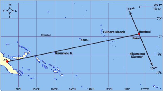
is that she turned back along the line towards Lae (her origin) in the knowledge she had fuel to possibly hit a chain of islands before darkness.
more chance of seeing landfall than hanging around trying to spot the specks of a support ship, howland or baker islands...
at the end of WW2 on the pretty much unknown and uncharted island of New Britain (which was along the line of AE flight) some Ozzie troops clearing out the last of the Japs and came across wreckage of an a/c and logged engine P&W serial number which are the same as AE's a/c.
this was all reported back to HQ and forgotten.
a chap called Dave who posts on here has been back to that region a few times and has met the veterans of the Oz patrol and has a location map to try and find the wreck which is deep under a jungle canopy.
real boys own stuff and wildly fascinating, wish i could go along!
http://www.pprune.org/non-airline-tr...rts-again.html
Let's Look For Amelia Earhart's Plane. | Indiegogo
TIGHAR has theirs...and its plausible,
as a young girl listening as a keen radio ham on the US east coast heard a faint transmission of an american woman clearly in distress and she made out the words she thought sounded like 'new york city'
that of course maybe 'norwich city' which was the wreck of the steamer on the island TIGHAR has been searching and where they think the plane landed close to the wreck on the reef.
no search was made here after the loss and anyone would have died eventually.
the other theory which is most interesting,
is that she turned back along the line towards Lae (her origin) in the knowledge she had fuel to possibly hit a chain of islands before darkness.
more chance of seeing landfall than hanging around trying to spot the specks of a support ship, howland or baker islands...
at the end of WW2 on the pretty much unknown and uncharted island of New Britain (which was along the line of AE flight) some Ozzie troops clearing out the last of the Japs and came across wreckage of an a/c and logged engine P&W serial number which are the same as AE's a/c.
this was all reported back to HQ and forgotten.
a chap called Dave who posts on here has been back to that region a few times and has met the veterans of the Oz patrol and has a location map to try and find the wreck which is deep under a jungle canopy.
real boys own stuff and wildly fascinating, wish i could go along!
http://www.pprune.org/non-airline-tr...rts-again.html
Let's Look For Amelia Earhart's Plane. | Indiegogo
Last edited by rog747; 5th Jun 2013 at 09:29.
the theory was that with her knowledge of running the engines on a lean mixture and with the winds it was thought possible she had more fuel than realised so
hence the possibility to find a wreck on N.B
hence the possibility to find a wreck on N.B
Lindberg, another expert on lean mixtures, advised the P38 pilots in the Pacific how to extend their range. This led to them being able to fly the long intercept to shoot down Admiral Yamamato.
new Britain theory
from what i gather they did not exactly have a notified back-up plan...as such
it was assumed they would find howland and the ship...
but she said to Mr Vidal that she would turn back to try and hit the islands
if it all went wrong.
''Earhart had stated to Gene Vidal, when asked what she would do if she could not find Howland: "I will turn back for the Gilbert Islands, find a place to put it down on the land, find a beach, or ditch close to shore."
In the first attempt she made in March 1937, the plan had been to leave Hawaii with 900 USG of fuel and fly to Howland Island, a distance of 1900 miles. Her contingency was the same..."the Gilbert's". Now, that means that 900 USG was enough for the 1900 miles HAWAII-HOWLAND plus another 600 miles, HOW-GILBERTS. That means 2500 miles on 900 USG. For the LAE-HOW flight she carried 1100 USG which then, was enough for 2556 + 600 miles = 3156 miles, at "Cruise" power.
Why would she then, at the last minute, unsure of her position, change her mind and head for Gardner when she was unsure of her position, instead of heading for the North-South spread of the Gilbert's which extends for some 500 miles and is difficult to miss ? You cannot navigate from an "unknown" position to another "known" position, you have no means of navigating.
Heading for the Gilbert's would in certainty guarantee a landfall.

Join Date: Jun 2013
Location: Seattle, WA USA
Posts: 3
Likes: 0
Received 0 Likes
on
0 Posts
Flying the line..
She didn't say she would keep flying it forever. What she maybe said that went unheard because of radio problems is another question.
There was a report that she later radioed that land was in sight. But that report had the wrong date and might have actually been made only a few hours after she took off... The plot thickens.
There was a report that she later radioed that land was in sight. But that report had the wrong date and might have actually been made only a few hours after she took off... The plot thickens.
Join Date: Jul 2007
Location: Lincolnshire
Posts: 365
Likes: 0
Received 0 Likes
on
0 Posts
I would be very surprised if the TIGHAR image represents anything other than a seabed anomaly. It is a very coarse pixellated image. Compare it with the stunning Dornier image that was published more or less at the same time. This was produced using multibeam technology, it is expensive but the results leave little doubt as to what is lying on the seabed.
As mentioned above TIGHAR depend on voluntary funds so every now and then they have to stir their donors up.
As mentioned above TIGHAR depend on voluntary funds so every now and then they have to stir their donors up.
Join Date: Feb 2006
Location: Hostage to geographical fortune.
Posts: 89
Likes: 0
Received 0 Likes
on
0 Posts
TIGHAR depend on voluntary funds so every now and then they have to stir their donors up.
Amelia Earhart plane lawsuit says wreckage was found in 2010
Join Date: Sep 2007
Location: On the Rump of Pendle Hill Lancashi
Posts: 614
Likes: 0
Received 0 Likes
on
0 Posts
I would be prepared to bet a full pint of Guiness, that absolutely nothing exists of the Aircraft Amelia flew, why wast funds looking for it now, far better to try and find the "Golden Fleece"!
Peter R-B
Lancashre
Peter R-B
Lancashre
Join Date: Jul 2008
Location: Australia
Age: 84
Posts: 200
Likes: 0
Received 0 Likes
on
0 Posts
Responses to three posters....
For rog747:
The Vidal statement was made during a taped interview and the tape rests in the University of Wisconsin, along with his memorabilia papers and is said to be in Box 40.
When I ran a look at the fuel on the first attempt flight from SFO to HI (Wheeler Field) in March 1937, I did so in regards to Earhart's own statement that she did not want to arrve at Wheeler in the dark and for the last two hours going into Hawaii she throttled back. Page 37 of the book "Last Flight" has her saying in the text and on a picture one of the paper slips she used to pass messages to Noonan: "10,000 feet, 120 mph and using less than 20USG of gas...". I think the 120mph would have been Corrected Indicated Airspeed which for which indications lean towards that being an earier term for TAS. Her usual CRUISE setting at the 14 hour point of a long-distance flight would be around 38 USGPH. So, in wanting to "slow" the aircraft down she would use less than the normal CRUISE power. "Reverse engineering" this flight gave a clue that the aircraft as operated by Earhart used up to 10% less gas in cruise than the Lockheed figures. She arrived at Wheeler just after dawn.
Some disagree about the "using less than 20USGPH" and say that the "20" was for each engine, ie; 40 USGPH but that does not gel with the normal CRUISE setting of 38 USGPH which delivered 150 mph in still air at 10,000 feet and she wanted to slow the aircraft down, not maintain a CRUISE speed. Logic says, therefore, that she would use less than 38 USGPH. The Pacific crossing SFO to HI had a tailwind.
The ranges "rog747" cites would need a bit of extra time and therefore range as well, that is time and range to find a suitable crashsite once she has reached an island in The Gilberts. She would have to look for some civilisation and land close to it in case they were injured in the pile up.... Medical assistance would be a bit thin in The Gilberts in 1937.
There is also the Flight Plan which her mapmaker (Commander Clarence Williams), made for her for a flight from ADEN-DAKAR of 4307 Statute Miles in 28 Hours 40 minutes NIL wind. MY calculations say she would need a constant tailwind of 12 mph to do that over the time, or an extra 267 USG in NIL wind. But, the FP is there, so why plan it if you cannot do it ?
For Little Sammy:
The radio call you are referring to was recorded by researcher Fred Goerner who saw, in a USN File, a message heard by NAURU Radio at 1030 ITASCA Local time (Itasca was the Coastguard ship waiting for her at Howland) that "Land in sight ahead" had been heard on 6210Kcs and only heard by Nauru. If it was her, and if it was The Gilberts, the time of 1030 Local ITASCA Time translates at 2200GMT 2nd July. This is one and three-quarters of an hour "after" the supposed last call at 2014GMT.
In 1.75 Hours at CRUISE power from 2014GMT, witha tailwind of 25mph, she would travel around 300 statute miles which would mean that they were 200-250 miles "short" of Howland at any turnback point after 2014GMT, if the turnback occurred then.
Three other calls heard on 6210Kcs at 0831 GMT, 0843 GMT and 0854 GMT on 3rd July were again only heard by Nauru Radio and the Operator said that there was "no hum of plane in the background but the voice sounded the same as I heard the mnight before..." (which would be the 1030GMT 2nd July call: "Ship in sight ahead" made when Earhart was outbound from LAE to Howland.
To me, three nearly evenly spaced calls like those, sound like a Station trying to raise another Station, but at the time of night, nearly 7:00pm Local in RABAUL, New Guinea (and SYDNEY, Australia), the Rabaul Radio station would be shut down and it did not have 6210Kcs in any case.
For PeterRB:
I think you are wrong there Peter, there would be some parts remaining even if in the sea. The Dornier Engines were still there as was the disintegrating airframe.
The Jungle is a different case altogether as aluminium does stand up very well in the jungle. A recent Corsair wreck that was partially buried exhibited fairly bright aluminium and other wrecks I have seen in Papua New Guinea have been the same.
If our Project is correct and the wreck seen in 1945 by Australian Diggers was the Electra, it will still be there. All the evidence we have points to the wreck being the Electra.
If you review my website (below) bear in mind that I got the time of the Nauru Radio intercept "Land in sight ahead" incorrect and the time of 2200GMT is the correct time (not 0030GMT).
Regards,
David Billings
www.electranewbritain.com
