


Mountain ridge crossing - safety review?

Thread Starter
Join Date: Dec 2014
Location: LHBS
Posts: 281
Likes: 0
Received 0 Likes
on
0 Posts
Forecast, reports and satellite will give an indication of where the clouds are. Mind you, in the mountains, afternoon weather tends to get active. There's a reason for "Alpine Starts".
You need to learn local weather patterns and fly when the weather is in your favor.
You need to learn local weather patterns and fly when the weather is in your favor.
 Looks like mountain weather can sometimes trick even the most experienced locals, can't assume anything.
Overflying cloud you do need fuel to turn back to good weather if you can't find a way down. Just be very sure it won't close in behind
If you seriously screw up the drill is to get over low ground and high ceilings before thinking of a descent. ATC needs to know. If all goes well, the paperwork will be waiting
If you seriously screw up the drill is to get over low ground and high ceilings before thinking of a descent. ATC needs to know. If all goes well, the paperwork will be waiting
 But when I wanted to see first, what the situation was below the cloud base, I slipped through...
 ...and this is why I am here now.

Join Date: Jul 1999
Location: Out of a Suitcase
Posts: 155
Likes: 0
Received 0 Likes
on
0 Posts
I'm surprised nobody has commented on the last part of your video.
First approach high - go around was the correct decision.
Second approach had you floating down the runway (too fast on approach?) and it looks like you touched down at the halfway point. You almost ran off the end - very poor judgement to continue this landing imho.
I was taught to land in the first third of any runway and use the second third for braking with the final third as a reserve.
Thread Starter
Join Date: Dec 2014
Location: LHBS
Posts: 281
Likes: 0
Received 0 Likes
on
0 Posts
The ridge crest crossing took place here, from South-East to North West direction on 20th August, around 13:15 CET = 11:15 UTC:https://goo.gl/maps/1NLvF17sadS2
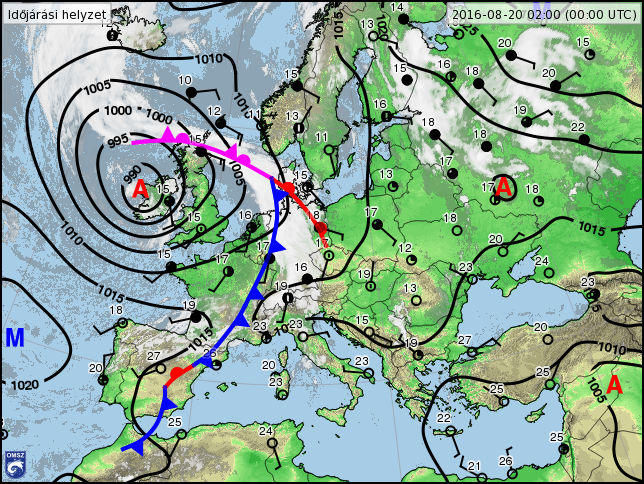
This is the synopic chart for that day (00:00 UTC) - to my inexperienced eyes, it looks like a quiet situation, being about 48 hour from an incoming cold front from the West.
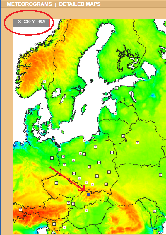
My forecast was taken from METEO.PL, model UM, 4km grid.
The location of the forecast was the little dark rectangle marked by red arrow, the map refers to it as X=220, Y=493.
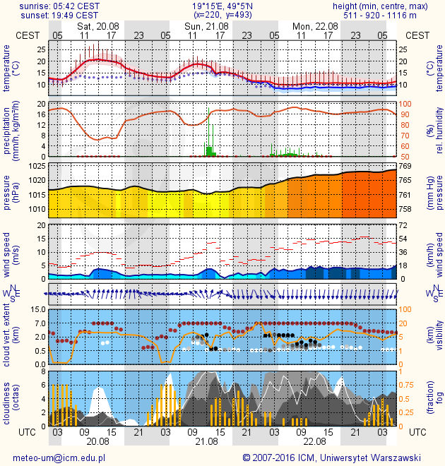
The last forecast I looked at was this - looks like a great day, high clouds only, and maximum 5-6 octas.
Last TAF from a regional airport 50 km East - this one looks great too, only few clouds, but there was also a hint of SCT clouds at 4500 feet with probability of 40%, however, no BKN or OVC clouds at all.
Code:
201608200500 TAF LZTT 200500Z 2006/2106 28004KT CAVOK
                      PROB30 TEMPO 2006/2007 6000 NSC
                      TEMPO 2007/2016 22007KT 9999 FEW050 SCT090
                       PROB40
                      TEMPO 2011/2015 SCT045 FEW060TCU=
Any thoughts what may have been overlooked, or what could have given the hint of so much cloud, i.e. a near overcast at 6000 feet over the ridge? Only the "mountain effect"?
Thread Starter
Join Date: Dec 2014
Location: LHBS
Posts: 281
Likes: 0
Received 0 Likes
on
0 Posts
I'm surprised nobody has commented on the last part of your video.
First approach high - go around was the correct decision.
Second approach had you floating down the runway (too fast on approach?) and it looks like you touched down at the halfway point. You almost ran off the end - very poor judgement to continue this landing imho.
First approach high - go around was the correct decision.
Second approach had you floating down the runway (too fast on approach?) and it looks like you touched down at the halfway point. You almost ran off the end - very poor judgement to continue this landing imho.
Last edited by rnzoli; 30th Aug 2016 at 15:36. Reason: Corrected runway designation
You seem to have made a commendable preflight effort to assess the weather
Mountains make their own weather - and often fools out of forecasters, including those who put too much faith in the forecasts
On one night flight over the Alleghanies, the forecast was "high scattered FL 330"
- which held until I found myself inside cloud at 6500'
Mountains make their own weather - and often fools out of forecasters, including those who put too much faith in the forecasts
On one night flight over the Alleghanies, the forecast was "high scattered FL 330"
- which held until I found myself inside cloud at 6500'
My comments.
I would have either climbed above the cloud for the ridge crossing or descended to give better forward visibility. There appeared to be a much better option out to you right, a lower part of the ridge and better visibility, which I suspect you didn't notice as you were looking directly ahead. Had you been lower it would have been much easier to spot.
Flying through those wispy bits of cloud isn't a good idea. Get below the cloud to get a better look ahead and around you. You will have a much better idea of whether or not to proceed. Sure you may need to climb a little to cross the ridge later on, but probably not if the conditions are suitable for you to cross.
Going high is going to give a better ride on the leeward side. Though to be honest the turbulence you encountered didn't look too bad. You can expect far worse in some situations. As a rule of thumb if the winds are more than 10 knots down low (say at a nearby airport), don't fly in the mountains, or if you do, be prepared for turbulence and know where to expect it and how to deal with its impact.
As for climbing above the cloud and knowing it its clear on the other side. If you start off low you should be able to see through to the other side of the ridge at some point. If there is plenty of sunshine on the ground on the other side then there should places to descend.
Always approach a ridge at well less than 90 degrees. There's no one perfect angle to approach the ridge at but lets use 45 degrees for this example. If you need to turn a way, depending on the surrounding terrain, a turn of a little more than 45 degrees will take you away from the terrain. With a shallow angle you have more time to assess conditions on the other side of the ridge.
Particularly if your are on the windward side you can fly along the ridge to pick the best point to cross. If you are on the lee side if you encounter a downdraft it's much less risky than approaching the ridge head on.
I'd also like to comment on your landing. Firstly congratulations on deciding to go around the first time.
I need to ask why you didn't fly the circuit for the same runway but elected instead to reposition for the opposite runway? Why did you chose Rwy08 for the first approach and not the second? As you said yourself the approach for 26 has issues. Be repositioning like you did you are setting yourself up for a non standard situation at an unfamiliar airfield. For many low hour pilots just landing at an unfamiliar airfield is enough for them to be out of their comfort zone and make silly small mistakes. Don't increase the risk by doing something non standard.
There are benefits in flying the circuit and landing on the same runway, unless it's obvious you chose incorrectly the first time, then it's not a bad idea to fly three legs of the circuit of the new runway. The benefits are you get yourself properly orientated and ensure you are not doing something non standard and forgetting something or make a mistake.
I know the ATC person said wind calm, that's almost at ground level, what were the prevailing upper winds? These will give you an indication of the possibility of a tailwind on final approach. Bearing in mind local terrain can modify the wind flows. If the wind is calm or fickle choose the runway that faces into the upper prevailing winds, especially if it is short.
Lastly you mentioned you were stabilised on the approach at 65 to 70 knots, yet you seemed to float a long way down the runway, far far further than I as an instructor would have been comfortable with. If I have been sitting beside you I would have instructed you to go around.
What speed did you cross the threshold at? Hopefully not 65 knots. If the figures I have for the Katana DV20 are correct (38 KIAS stall speed full flap) then with full flap extended at all up weight you should be crossing the threshold at 50 KIAS.
Hopefully my comments will be of help to you in the future.
Last edited by 27/09; 31st Aug 2016 at 01:49.
Thread Starter
Join Date: Dec 2014
Location: LHBS
Posts: 281
Likes: 0
Received 0 Likes
on
0 Posts
Affirm, the red line is the gust level in their charts.
Many thanks for looking into the details. So I take away that such high-mountain crossing VFR flight should be prepared for
- early morning (before convective activity becomes too strong)
- with anticyclonal high pressure air over the mountainous part of the route
- with only CAVOK or FEW clouds in a sufficiently close TAF (SCT is a warning, BKN OVC TCU CB SHRA, TSHRA are clear no-go's)
- with surface winds in the valleys not above 5-10 kts (average).
Yes, indeed, and actually I chose this airfield and the overfly route to learn something new about such terrain. I was just surprised how steep the learning curve was, but since me and the plane came home together as planned, I am not complaining at all, it's valuable experience for sure, more valuable in fact, than a lucky uneventful flight would have been.
Hence, my (old-style) VFR conditions look rather unlikely.
- early morning (before convective activity becomes too strong)
- with anticyclonal high pressure air over the mountainous part of the route
- with only CAVOK or FEW clouds in a sufficiently close TAF (SCT is a warning, BKN OVC TCU CB SHRA, TSHRA are clear no-go's)
- with surface winds in the valleys not above 5-10 kts (average).
Never mind, experience comes from a series of mistakes through life. You have learnt something and got away unscathed. Gruss Gott.
Thread Starter
Join Date: Dec 2014
Location: LHBS
Posts: 281
Likes: 0
Received 0 Likes
on
0 Posts
As for climbing above the cloud and knowing it its clear on the other side. If you start off low you should be able to see through to the other side of the ridge at some point. If there is plenty of sunshine on the ground on the other side then there should places to descend.
I'd also like to comment on your landing. Firstly congratulations on deciding to go around the first time.
I need to ask why you didn't fly the circuit for the same runway but elected instead to reposition for the opposite runway? Why did you chose Rwy08 for the first approach and not the second? As you said yourself the approach for 26 has issues.
There are benefits in flying the circuit and landing on the same runway, unless it's obvious you chose incorrectly the first time, then it's not a bad idea to fly three legs of the circuit of the new runway. The benefits are you get yourself properly orientated and ensure you are not doing something non standard and forgetting something or make a mistake.
Lastly you mentioned you were stabilised on the approach at 65 to 70 knots, yet you seemed to float a long way down the runway, far far further than I as an instructor would have been comfortable with. If I have been sitting beside you I would have instructed you to go around.
 What I mean is that directional control and the long flare over the narrow and rising/falling runway took great deal of my attention, and I noticed the other threshold coming up, instead of noticing how much runway was already gone behind. That was 1-2 seconds already too late.
What speed did you cross the threshold at? Hopefully not 65 knots. If the figures I have for the Katana DV20 are correct (38 KIAS stall speed full flap) then with full flap extended at all up weight you should be crossing the threshold at 50 KIAS.
Hopefully my comments will be of help to you in the future.
Thread Starter
Join Date: Dec 2014
Location: LHBS
Posts: 281
Likes: 0
Received 0 Likes
on
0 Posts
This certainly enables me to become a better pilot step-by-step.I am also updating the video description with the advice I receive, so it might help the awareness of those, who are planning to do a similar flight under similar circumstances.
Join Date: Jul 2008
Location: BC, Canada
Posts: 88
Likes: 0
Received 0 Likes
on
0 Posts
Thank you to Mary and EGQL1964 for your kind comments. I'm certainly no expert or a definitive authority on such matters - just a bit of hard won experience from working in and around the mountains. Hopefully rnzoli continues to enjoy his flying and is to be commended for seeking feedback in such a public manner.
Mary - I did fly in a glider from Sutton Bank once; the lack of noise/vibration was somewhat disconcerting!
EGQL1964 - as an expat Scot, I'm certainly used to the weather being less than CAVOK!
Mary - I did fly in a glider from Sutton Bank once; the lack of noise/vibration was somewhat disconcerting!
EGQL1964 - as an expat Scot, I'm certainly used to the weather being less than CAVOK!
In an aircraft with an approach speed of 50 kt ( 1.3 x 38 Vso) at full gross, consider that 65 kt = 1.7 Vso.
Landing at 65 kt gives you 70% more kinetic energy to be dissipated by the brakes (with small assists from drag and rolling resistance).
In a healthy 15 kt wind, your groundspeed over the threshold would be 50 and reasonable for the runway in question.
But zero wind combined with a 65 kt approach will have you getting intimate with the other end of the runway - 70% more KE
Flying by yourself with some 2 hours of gas will have you well below gross weight.
I leave it as an exercise for you to calculate:
Square root (LW/MG) x 50 kt
Where:
LW - Landing Weight
MG - Maximum Gross Weight
to determine a zero wind approach speed corrected for weight.
rnzoli: 65 kts I am afraid. We are instructed to approach at 70 kts in general, or at 60-65 kts for short runways. This is to cover windshear, variable winds, distraction or poor monitoring of airspeed etc. And this turns against us when we go for these small places. Especially that RWY 26 threshold seems accessible to a precise flare only by cutting the throttle a tad earlier, slowing down to 55-60 kts over the last part of terrain and then agressively drop in over the 50 m CWY (posibly picking up +5 kts in the process). I missed that, so in reality, I was also 1-2 meter too high over the threshold, contributing to the long flare.
By all means fly the approach at 65 to 70 knots, but slow up on short finals to a speed appropriate for the conditions. Plan to be at 50' AGL over the runway end/threshold/fence, (as appropriate), at your target threshold speed. This will normally mean reducing power at around 500' AGL plus or minus depending on conditions, aircraft weight and performance.
You should aim for a threshold speed of 1.3 X stall speed for that configuration.
The information I have tells me the DA 20 has a full flap stall speed of 38 KIAS. 1.3 X 38 = 49.4 KIAS. Check your flight manual. You need the wings level, full flap, power off figure in indicated airspeed (IAS).
I would expect anyone who has a PPL to be able to maintain their airspeed by plus or minus 5 knots, you have to be more than 10 knots slower than your target threshold speed before you will stall. You will unlikely to be at MAUW for you landing anyway, so your stall speed will be less than 38 KIAS.
Remember your speed is slowly reducing from 65 to 70 knots at 500' AGL to 50 knots at 50' AGL, so you're not trying to fly along maintaining 50 knots.
Once you cross the threshold don't leave the power on, reduce the power to idle to allow the aircraft to slow and settle onto the runway. Remember to keep increasing the elevator back pressure to stop the nose from dropping. I'm probably telling you stuff you already do here.
Think of every touchdown as the approach to a power off full flap stall that is prevented by the wheels kissing the ground.
You will probably be touching down at about 40 to 42 knots, not that you should be watching the ASI at this point.
If there are wind gusts, add 1/2 the gust factor to your base speed. E.G. If the wind is 10 knots gusting to 20 knots there is a gust factor of 10 so add half of that (5 knots) to your base speed.
How often on the days you fly do you encountered gusty or windshear conditions? You will see from the paragraph above that you need a 20 knot gust factor before you need that target threshold speed of 60 knots.
Fly to the conditions, don't carry any unnecessary speed. Adjust your threshold speed to suit. Keep you hand on the throttle so that you can make prompt adjustments.
Go and try what I have suggested regarding slowing up to a target threshold speed, do it and practice it at a familiar airfield. Once you have it mastered you will be surprised how much less runway and braking action you will need.
RatherBeFlying: In an aircraft with an approach speed of 50 kt ( 1.3 x 38 Vso) at full gross
You make a good point about reducing threshold speed relative to weight.
I haven't done the figures for a while, however from memory for the weight changes involved in most light aircraft the change in Vs due to weight isn't significant enough to have to bother with calculating a new 50' speed.
In the case of a DA20 I think 50 KIAS will work all the time, adjusted for wind gust etc if required.
Thread Starter
Join Date: Dec 2014
Location: LHBS
Posts: 281
Likes: 0
Received 0 Likes
on
0 Posts
OK, let's do some more analyis for the landing at Jasna! 
I was complacent because I had no trouble landing at a similarly short airfield before, several times. Just looked at RWY lenght, seemed comparable, so instead of calculating landing performance and target speeds, I spent more time with weather checking
And then here are the facts.
My earlier experienced short field:
LHJK: RWY 14/32 600 X 18 m, CWY 200 + 200 m grass, ARP elevation 364 ft, no sloping
And the field in the video:
LZJS: RWY 08/26, 544 x 15 m, CWY 50 +50 m, ARP elevation 641 m, 2103 ft (middle), both thresholds at 639 m / 2096 ft. (with grass outline, 644 x 35).
Only 10% shorter, little narrower, but what's the big deal?
Well, it's 1700 feet higher, much shorter clearway at both ends, and I was always there in LHJK with 2 persons (instructor or passager), i.e, greater weight.
Let's check the aircraft actual performance. I took a few screenshots from original video recording and enlarged them to see instruments better:
Aircraft:
This is what the DV Aircraft Flight Manual (AFM) says for landing performance:
Conditions:
Landing roll distance: approx. 228 m (*note by me = this means touch down 454 - 228 = 226 meters from threshold)
For each 750 m (2500 ft) additional height above MSL add 1 0% to the landing distance. (*note by me, the landing roll distance doesn't change with altitude)
So let's adjust this to the actual performance:
Adjustment for MSL: 2060/2500 * 10 = +8.3% 454 * +8.3% = : 491 m landing distance
Adjustment for speed: (65 kts^2)/(59 kts ^2) --> +21% = 595 m
Adjustment for weight = 730/641 = -->+13% = 677 m
Landing point = 677 m-90 -228 =359 m (66% of runway)
Stopping point: 677 -90 = 577 = 587 m (43 meters over end of runway, 7 meters left from 50 m clearway).
Fairly close, the actual landing roll was shorter due to lower weight, clear runway, good traction, hard breaking.
Then how should it have been done well?
Target approach speed for lower weight: Square root (641 /730) * 59 = 55 kts.
This woud give us the following distances in the AFM model:
Adjustment for MSL: 2060/2500 * 10 = +8.3% 454 * +8.3% = : 491 m landing distance
Adjustment for speed: 55^2/59^2 = -13% (491 *0.87 = 427 m)
Adjustment for weight: 730/641 = -->+13% (427 * 1.13) = 482 m
Touchdown point: (482-228 -90 = 164 m from threshold, at 30% of runway length, right at the taxiway exit !
Stopping point: 482-90 = 392 m from threshold, using 72% of runway length)
So in short, 55 kts on approach, cut throttle at +50 ft/15m and I land at 1/3 of runway and stop in the next 1/3, leaving the last 1/3 for reserve. It could have been just like a textbook landing!
Now let's play more - how about landing at MTOW? Assume I take fat passenger, top up fuel, and after takeoff, he remembers leaving his wallet on the ground.
Adjustment for MSL: 2060/2500 * 10 = +8.3% 454 * +8.3% = : 491 m landing distance
Adjustment for speed: 59^2/59^2 = +0% (491 m)
Adjustment for weight: 730/730 = +0% (491 m)
Touchdown point: 491 -228 - 90 = 173m at 31% of the runway
Stopping point: 491-90 = 401 m m from threshold, using 73% of runway length.
No problem either!
I was complacent because I had no trouble landing at a similarly short airfield before, several times. Just looked at RWY lenght, seemed comparable, so instead of calculating landing performance and target speeds, I spent more time with weather checking
And then here are the facts.
My earlier experienced short field:
LHJK: RWY 14/32 600 X 18 m, CWY 200 + 200 m grass, ARP elevation 364 ft, no sloping
And the field in the video:
LZJS: RWY 08/26, 544 x 15 m, CWY 50 +50 m, ARP elevation 641 m, 2103 ft (middle), both thresholds at 639 m / 2096 ft. (with grass outline, 644 x 35).
Only 10% shorter, little narrower, but what's the big deal?
Well, it's 1700 feet higher, much shorter clearway at both ends, and I was always there in LHJK with 2 persons (instructor or passager), i.e, greater weight.
Let's check the aircraft actual performance. I took a few screenshots from original video recording and enlarged them to see instruments better:
Aircraft:
- weight MTOW 730 kg, approx. actual weight 520 empty +68 pilot +10 baggage + 43 fuel (58 lit) = 641 kg
- flaps - landing flaps deployed (confirmed in video at 10:55)
- throttle cut at +50 feet/+15m (2110 baro alt), 90 m from threshold, manifold pressure idle (11:55 in video, also correlates to GPS track
- threshold - crossed at 63 KIAS at 2080 ft baro alt with VSI 900 fpm (11:59 in video)
- wind - windsock on hangar confirm calm (12:02 in video)
- flare - flew by taxiway exit at 54 KIAS, 2065 ft baro alt with VSI 500 fpm
- touchdown - 41 kts, 2060 ft baro alt VSI 200 fpm, at the 4th outer grass runway marker, which is according to Google Maps, c.a. 360 meters from threshold, (12:11)
- stop - came to a halt in remaining 184 meters, giving a total of 90+360+184 = 634 meters from +50 feet/15m point, using 100% runway.
This is what the DV Aircraft Flight Manual (AFM) says for landing performance:
Conditions:
- - Idle
- - Maximum T/O Mass (Weight)
- - max RPM
- - Approach speed 59 kts
- - level runway. paved
- - Flaps in landing position
- - Standard setting. MSL
Landing roll distance: approx. 228 m (*note by me = this means touch down 454 - 228 = 226 meters from threshold)
For each 750 m (2500 ft) additional height above MSL add 1 0% to the landing distance. (*note by me, the landing roll distance doesn't change with altitude)
So let's adjust this to the actual performance:
Adjustment for MSL: 2060/2500 * 10 = +8.3% 454 * +8.3% = : 491 m landing distance
Adjustment for speed: (65 kts^2)/(59 kts ^2) --> +21% = 595 m
Adjustment for weight = 730/641 = -->+13% = 677 m
Landing point = 677 m-90 -228 =359 m (66% of runway)
Stopping point: 677 -90 = 577 = 587 m (43 meters over end of runway, 7 meters left from 50 m clearway).
Fairly close, the actual landing roll was shorter due to lower weight, clear runway, good traction, hard breaking.
Then how should it have been done well?
Target approach speed for lower weight: Square root (641 /730) * 59 = 55 kts.
This woud give us the following distances in the AFM model:
Adjustment for MSL: 2060/2500 * 10 = +8.3% 454 * +8.3% = : 491 m landing distance
Adjustment for speed: 55^2/59^2 = -13% (491 *0.87 = 427 m)
Adjustment for weight: 730/641 = -->+13% (427 * 1.13) = 482 m
Touchdown point: (482-228 -90 = 164 m from threshold, at 30% of runway length, right at the taxiway exit !
Stopping point: 482-90 = 392 m from threshold, using 72% of runway length)
So in short, 55 kts on approach, cut throttle at +50 ft/15m and I land at 1/3 of runway and stop in the next 1/3, leaving the last 1/3 for reserve. It could have been just like a textbook landing!
Now let's play more - how about landing at MTOW? Assume I take fat passenger, top up fuel, and after takeoff, he remembers leaving his wallet on the ground.
Adjustment for MSL: 2060/2500 * 10 = +8.3% 454 * +8.3% = : 491 m landing distance
Adjustment for speed: 59^2/59^2 = +0% (491 m)
Adjustment for weight: 730/730 = +0% (491 m)
Touchdown point: 491 -228 - 90 = 173m at 31% of the runway
Stopping point: 491-90 = 401 m m from threshold, using 73% of runway length.
No problem either!
rnzoli
I would make one point about this statement
(*note by me, the landing roll distance doesn't change with altitude)
Otherwise you have done a good job of educating yourself on approach and landing speeds.
P.S.
The 1.3 Vs target threshold speed I mentioned in one of my earlier posts is the the minimum speed legislated for crossing the threshold.
Many POH landing performance figures are calculated using this figure. If this is the case you will need to fly this speed to meet the book figures.
It looks as if Diamond uses a higher figure than 1.3 Vs.
Thread Starter
Join Date: Dec 2014
Location: LHBS
Posts: 281
Likes: 0
Received 0 Likes
on
0 Posts
It looks as if Diamond uses a higher figure than 1.3 Vs.
DV20 Diamon Katana (MTOW 730 kg)
Vso= 38 kts
Approach speed = 59 kts (1.57 x Vso)
DA40 Diamond Star: (MTOW 1200 kg)
Vso = 52 kts
Approach speed = 73 kts (1.40 x Vso)
DA42 Diamond TwinStar ( MTOM 1999 kg)
Vso = 64 kts
Approach speed = 86 kts (1.34 x Vso)
Thread Starter
Join Date: Dec 2014
Location: LHBS
Posts: 281
Likes: 0
Received 0 Likes
on
0 Posts
Thanks, apparently I found the spirit of the moutain in good mood and he let me escape with the experience.
But today's tragic news from the same area shows how cruel the same mountains can be and how easily they take away lives, even with experienced pilots...

Helicopter crash in Slovakia kills four | Fox News
But today's tragic news from the same area shows how cruel the same mountains can be and how easily they take away lives, even with experienced pilots...
Helicopter crash in Slovakia kills four | Fox News
Thread Starter
Join Date: Dec 2014
Location: LHBS
Posts: 281
Likes: 0
Received 0 Likes
on
0 Posts
Yes, apparently. 11 PM local time.
Original article with google translator.. https://translate.google.com/transla...%2F&edit-text=
Original article with google translator.. https://translate.google.com/transla...%2F&edit-text=